“Heritage maps of Chester and York Counties, S.C.”
City Directories and History: (EDGEMOOR – LEWIS TURNOUT – LANDO – RODMAN – LEWISVILLE – RICHBURG – LANDSFORD – FISHING CREEK COMMUNITIES)
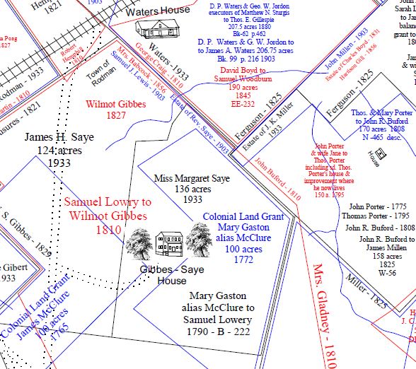
A collection of adjacent and overlapping historic plats – mainly from Chester County, S.C., diagramming the locations and geographic parameters of hundreds of family farms and grants of historic importance. These refined maps are the work of Chester resident and historian, Mr. Tom Mayhugh who graciously provided them for display and research on Roots and Recall in 2017.
Each is provided to and preserved on R&R to enhance local genealogical – historic preservation. As such R&R expects any use of theses to be credited appropriately! Click on each map title to reveal the plats for numerous sections of Chester County. Additional Mayhugh Heritage Maps are also available in Lancaster and York Counties.
***Permission for use maybe addressed to images@rootsandrecall.com, thank you.
*** Also see Heritage Plat Maps #II – The Mayhugh Collection for the Cornwell – Sandy River and Turkey Creek plats…..
Each of the “indexed” heritage plat maps are available and fully searchable on R&R.com. However not all maps have been indexed.
Stay Connected
Explore history, houses, and stories across S.C. Your membership provides you with updates on regional topics, information on historic research, preservation, and monthly feature articles. But remember R&R wants to hear from you and assist in preserving your own family genealogy and memorabilia.
Visit the Southern Queries – Forum to receive assistance in answering questions, discuss genealogy, and enjoy exploring preservation topics with other members. Also listed are several history and genealogical researchers for hire.
User comments welcome — post at the bottom of this page.
Please enjoy this structure and all those listed in Roots and Recall. But remember each is private property. So view them from a distance or from a public area such as the sidewalk or public road.
Do you have information to share and preserve? Family, school, church, or other older photos and stories are welcome. Send them digitally through the “Share Your Story” link, so they too might be posted on Roots and Recall.
Thanks!

User comments always welcome - please post at the bottom of this page.


Love the maps. I have learned a lot about my area. I have been at the county court house looking through a lot of deed books trying to find plats and names of people that use to live where I do now. I have found a metal wagon wheel, rail road spike, part of horse shoes and square nails. I know the land was known as Smith’s place Tract “A” part of the Smith estate and would like to know how big was the Smith place. It had been owed by John McFadden and then sold to the Marion family. The neighborhood is boarded by Old Richburg Road, McDanilel’s Branch Creek and Barber’s Creek. Are there any plats for this area in the 17 and 1800’s. John Marion bought it from John McFadden in 1885 but I can’t find plats to see if this is the same land I live on now. I think the area was boarded by Hicklin, McDaniel and Barber land.
Do you know if there are any plat maps for this area?
Take a look at: https://www.rootsandrecall.com/chester/buildings/2314-old-richburg-road/ as well as https://www.rootsandrecall.com/chester/buildings/union-arp-church/ (open the sites and read, the Union ARP page has an enlargeable map of Richburg by Mayhugh).
My Roden/Rawdon family lived in the Baton Rouge area outside of Chester. I am trying to find a map around 1790-1800 showing where they lived in relation to their neighbors the Wilks, Cornwells, and McCallums. Can anyone tell me where I might find these. Thank you.