

The line between Chester and York Counties according to the Act of Dec. 19, 1796 ran from the SW side of the Catawba River at a hickory tree about ten chains above the mouth of Ferrall’s Creek…., to an ash and gum on the banks of the Broad River on Robert Elliott’s land. P. 85, Dev. of S.C. Counties, 1995
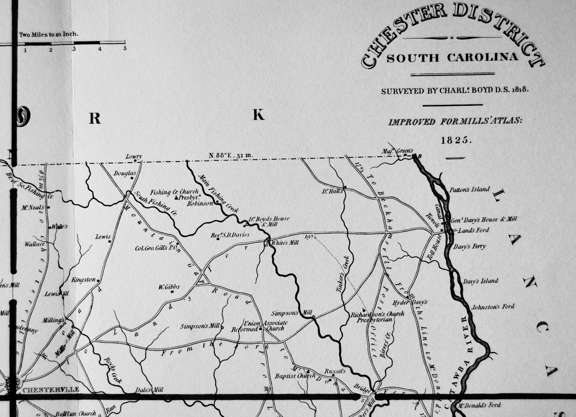
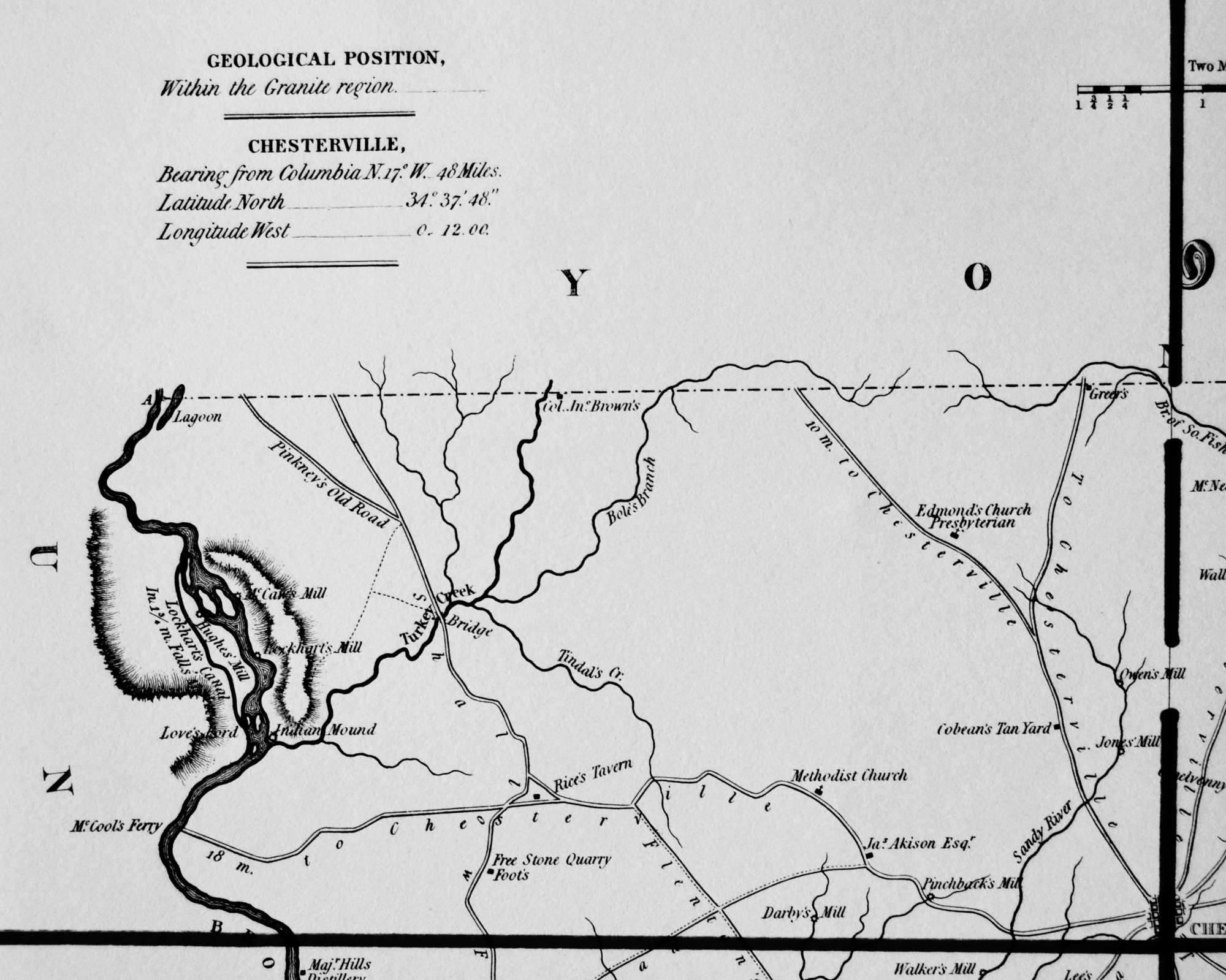
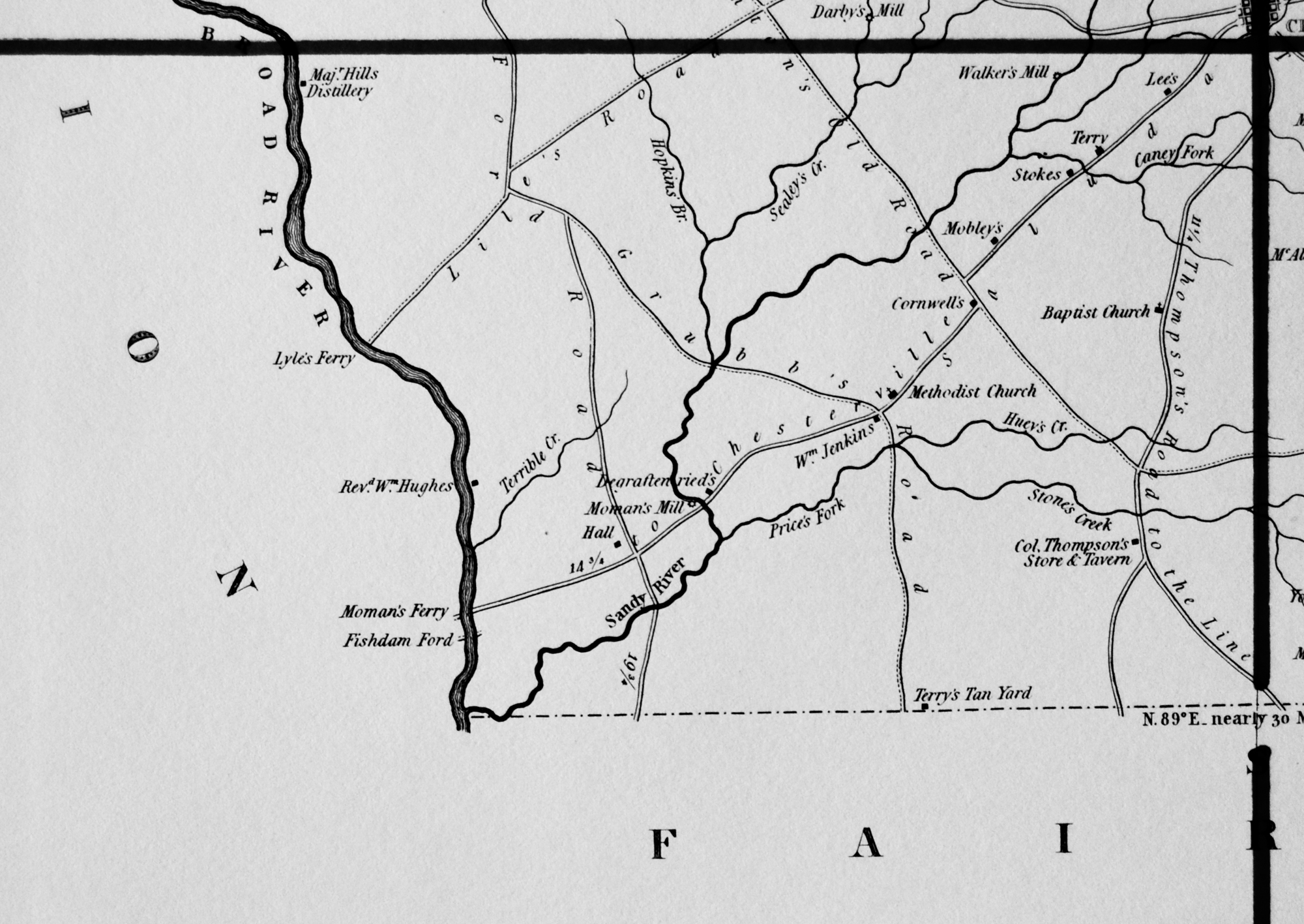
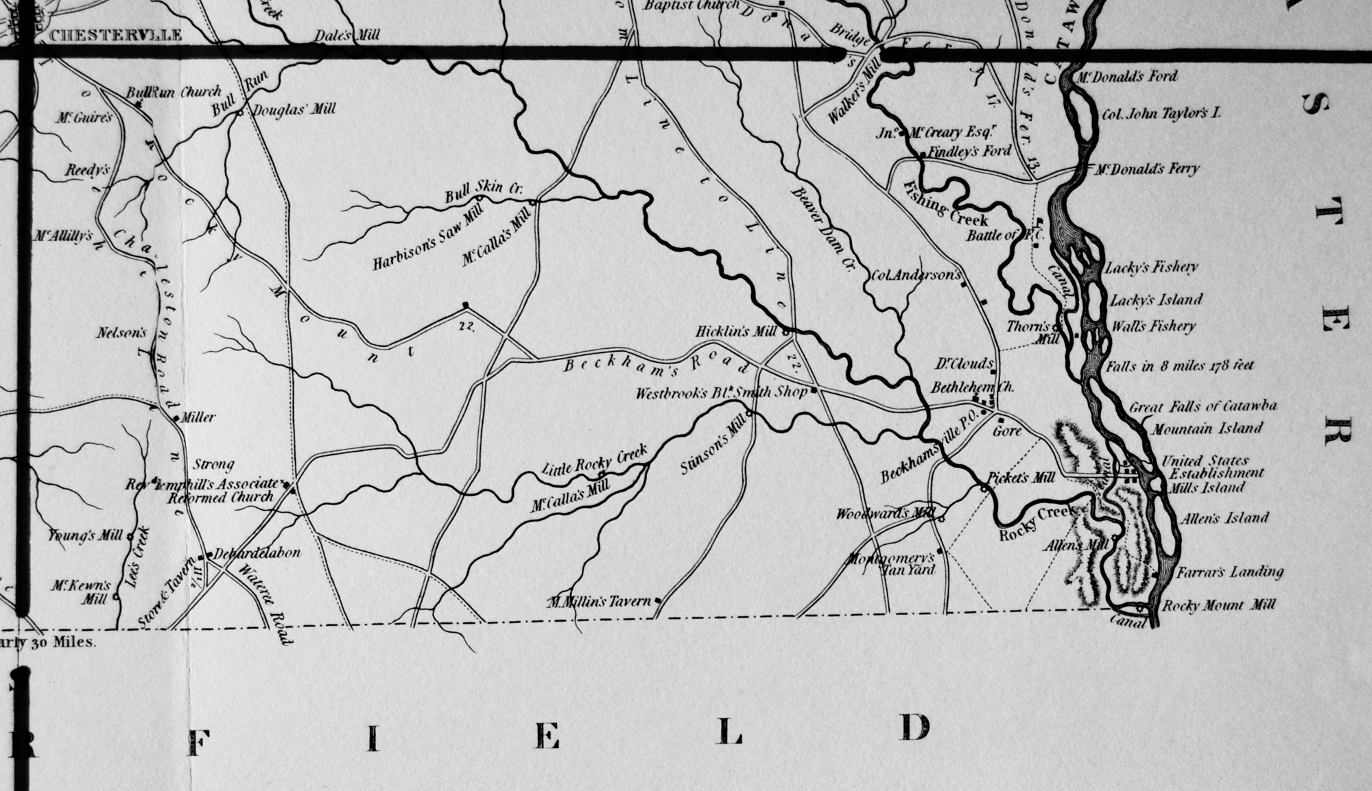
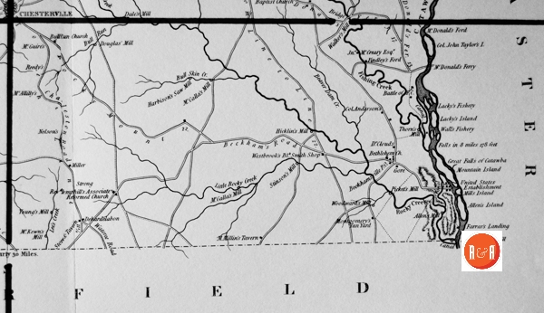
City Directories and History: Architect, Mr. Robert Mills was hired by the State of S.C. to create accurate maps of the state’s districts. In turn, he employed knowledgeable surveyors to survey the local areas, from which he created his finished maps of S.C., districts or counties. This resulted in accurate maps of roads, streams, and cities located in each. Click on the More Information / Enlargeable links, (found under the picture column), for an enlargeable county map, a history of Robert Mill’s survey of S.C. counties, written by Gene Waddell in 1980, an index to the names listed on the maps, and enlargeable quadrants for conducting in depth research.
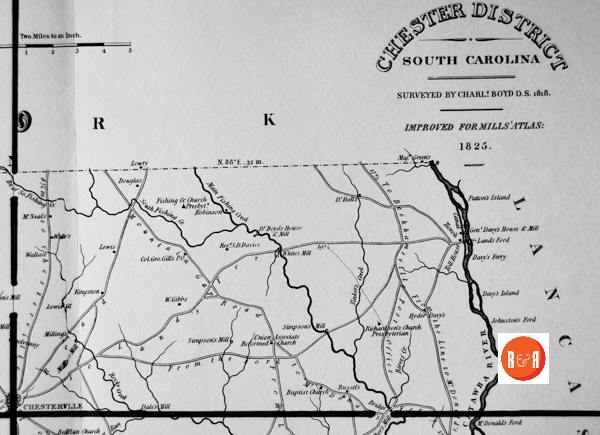
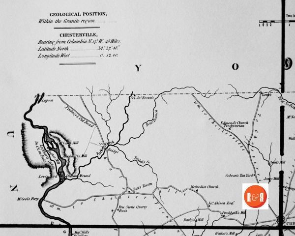
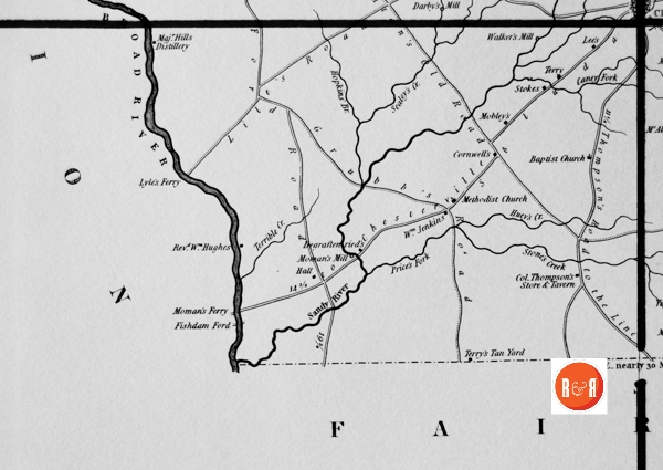
“Charles Boyd, Deputy Surveyor, prepared a survey of Chester District, where he probably lived in 1820. His manuscript is dated 30 November, 1818, and he was paid $1,000 the following month. When Gordon Moore soon afterwards presented a survey of York, it became clear that the boundary between the districts was two miles too long on one of the surveys. A resurvey exonerated Moore. Boyd had originally been hired by Governor Pickens to survey both of these districts, and if he had, his mistake might have gone undetected until he had been paid for both. Boyd had, in fact, begun the York survey, but Pickens directed him to desist. Boyd complained to the Legislature that his contract called for surveying both districts for $2,000 and that he would have charged $1,200 for Chester alone. He asked for an additional payment of $200, but his claim was unjustified. Chester has 566 square miles and York 693, even disregarding the inadequacy of his work. The Legislature ignored his petition.” Information from: Mill’s Atlas of South Carolina – 1825, Southern Historical Press, 1980 (Charles Boyd’s important survey of Chester Co., S.C. is also featured prominently throughout the pages of R&R.)
R&R has also taken individual county maps and created a list of their recorded sites, allowing R&R’s users, faster access to historic data. Each of the More Information links opens items connected to the Mill’s map of this county. The last four are those related to Quadrants 1-4. Names within each quadrant are listed below and at the bottom of the page, is an alphabetical list, of all names shown in Chester District, along with other counties in which the name also appears. Another excellent website to view the Mill’s maps is at Rumsey’s Maps.
Scroll down to view the alphabetical listing of names:
| Section #1 | Section #2 | Section #3 | Section #4 | ||||
| Allen’s Island – Ch, Lan | 1 | 82 m. to Chesterville – Ch | 2 | Akison, Jas. – Ch | 3 | 11 miles to Thompson’s Road to the Line – Ch | 4 |
| Allen’s Mill – A, Ch | 1 | Baptist Church | 2 | Bole’s Branch – Ch, Y | 3 | 14 to Chesterville Road- Ch | 4 |
| Anderson, Col. – Ch, P | 1 | Boyds, Dr., House and Mill – Ch | 2 | Broad River – A, Be, Ch, F, Lex, N, R, Sp (2), | 3 | Caney Fork – Ch | 4 |
| Battle of F.C. – Ch | 1 | Bridge – A (2), Ba (3), Be (6), Cha, Ch (2), | 2 | Brown Col. John | 3 | Cornwell – Ch | 4 |
| Beaver Dam Creek – Ch, E (2), Gr (2), Lau, | 1 | Dale’s Mill – Ch | 2 | Cobean’s Tan Yard – Ch | 3 | Degraffenreid – Ch | 4 |
| Beckham’s Road – Ch | 1 | Davies, Revd. S.D. – Ch | 2 | Darby’s Mill – Ch | 3 | Fishdam Ford – Ch | 4 |
| Beckhamsville P.O. – Ch | 1 | Davy, Hyder – Ch | 2 | Edmond’s Church Presbyterian – Ch | 3 | Grubb’s Road – Ch (2) | 4 |
| Bethlehem Church – Ch, Sp | 1 | Davy’s Ferry – Ch | 2 | Foot – Ch, U | 3 | Hall – Ch, K, Lau (2), N, O, Su | 4 |
| Bull Run Creek- Ch | 1 | Davy’s Island – Ch | 2 | Free Stone Quarry Foot’s – Ch | 3 | Hopkin’s Br. – Ch (2) | 4 |
| Bull Run Church – Ch | 1 | Davy’s, Gen.: House and Mill – Ch | 2 | Greer – Ch, H, Y | 3 | Huey’s Creek – Ch | 4 |
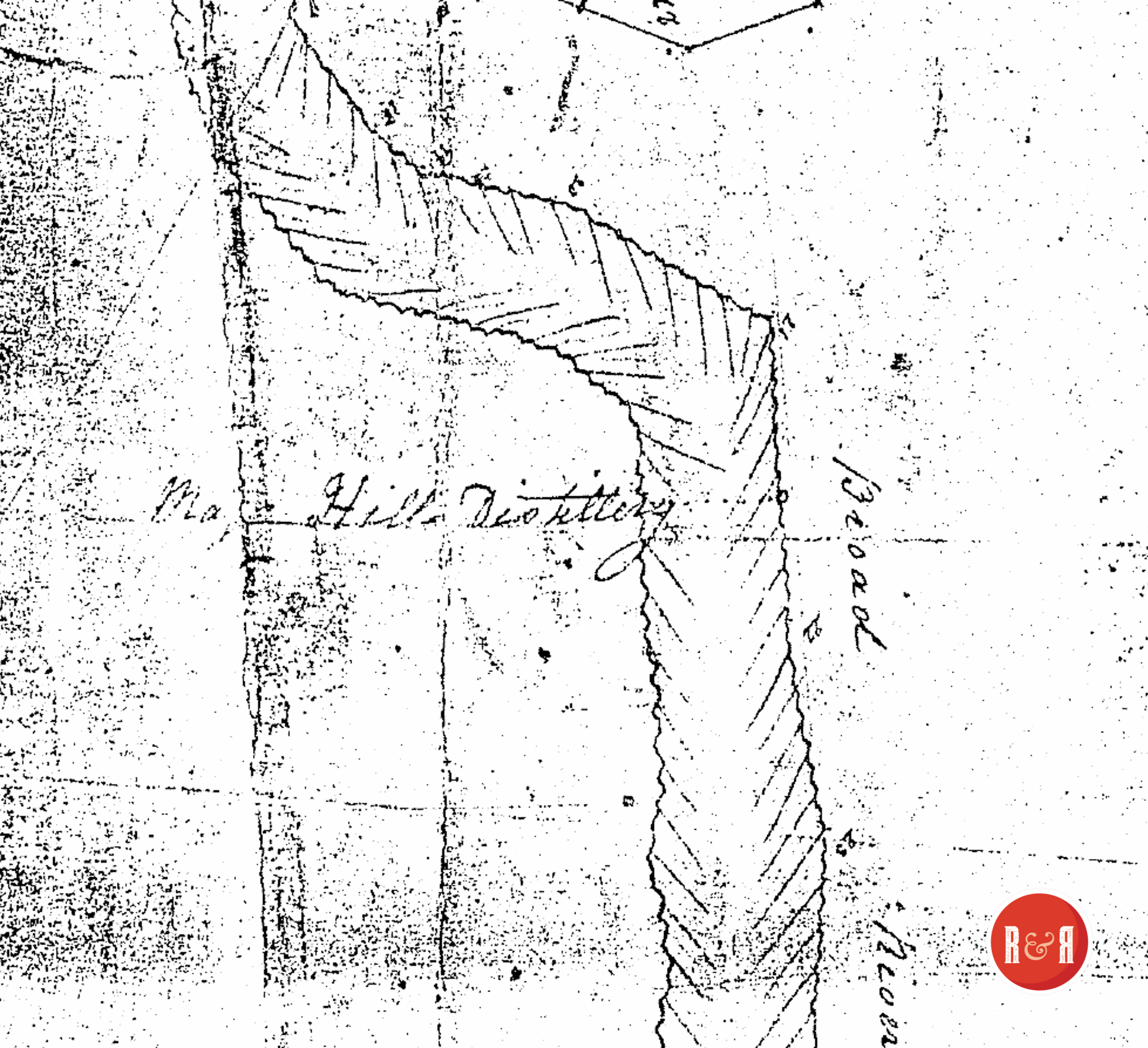
| Bull Skin Creek – Ch | 1 | Douglas – A, Ch, Lan | 2 | Hills, Maj.: Distillery – Ch | 3 | Lee – A, Ch, Co (2), E, F, H, K, Su (2), | 4 |
| Canal – Ch (3), Ge, K, Lex (2), R Lands Ford | 1 | Fishing Creek Church Pres. Ch | 2 | Hughes Mill – Ch | 3 | Lile’s Road – Ch | 4 |
| Charleston Road – Ch, O | 1 | Gibbs, W. – Ch | 2 | Indian Mound – Ch, W | 3 | Lyle’s Ferry – Ch | 4 |
| Clouds, Dr. – Ch | 1 | Gill’s, Col. Geo.: P.O.- Ch | 2 | Jones’ Mill – Ch | 3 | Mobley – Ch, F | 4 |
| Debardelabon – Ch | 1 | Green, Major – Ch, Y | 2 | Lagoon – Ch | 3 | Moman’s Ferry – Ch | 4 |
| Douglas’ Mill – A, Ch, R | 1 | Hall, Dr. – Ch | 2 | Lockhart’s Canal – Ch | 3 | Price’s Fork Creek Ch | 4 |
| Falls in 8 miles 178 feet – Ch | 1 | Johnston’s Ford – Ch | 2 | Lockhart’s Mill – Ch | 3 | Hughes, Wm. Rev. | 4 |
| Farrar’s Landing – Ch | 1 | Kingston – Ch (@Peter Wylie’s) | 2 | McCaw Mill- A, Ch | 3 | Sandy River – Ch (2), F, R, Su, W | 4 |
| Findley Ford – Ch | 1 | Land’s Ford – Ch, Lan | 2 | McCool’s Ferry – Ch | 3 | Sealey’s Creek – Ch | 4 |
| Fishing Creek | 1 | Lewis – Ch (2), D, Ge (2), H, P | 2 | Methodist Church – Be, Ch (2) | 3 | Stokes – Ba, Ch, Co (3), Gr | 4 |
| From the Fork to McDonald’s Ferry – Ch | 1 | Lowry – Ch, Ch’f, Su (2), Y | 2 | Moman’s Mill and Ferry – Ch | 3 | Terrible Creek – Ch | 4 |
| Gore – Ch, H | 1 | McNeal – Ch, Y | 2 | Owens Mill – Ch | 3 | Terry – Ch, F, Gr | 4 |
| Great Falls of Catawba – Ch, Lau | 1 | Milling – Ch | 2 | Pinchback’s Mill – Ch (Map #2) on headwaters of Shealey’s Creek | 3 | Terry’s Tan Yard – Ch, F (2) | 4 |
| Harbison’s Saw Mill – Ch | 1 | Milling’s Mill – Ch | 2 | Pinkney’s Old Road – Ch | 3 | Walker’s Mill – Ba (2), Ch (2) | 4 |
| Hicklin’s Mill – Ch | 1 | O’Melveny – Ch | 2 | Rice’s Tavern – Ch (2) | 3 | Wm. Jenkins – Ch | 4 |
| Lacky’s Fishery – Ch | 1 | Patton’s Island – Ch, Lan | 2 | Tindal’s Creek – Ch | 3 | Ald’s Ferry – Ch | NA |
| Lacky’s Island | 1 | Richardson’s Church Presbyterian | 2 | Turkey Creek | 3 | Falls 8 feet in 4 ch. – Ch (2), Sp | na |
| Little Rocky Creek – Ch | 1 | Robinson – Ch, Co, Lan, O, Su | 2 | Flenton’s Old Road – Ch (2) | 3 | McCane’s Mill – Ch | UN |
| Main Fishing Creek – Ch, Y | 1 | Rocky Creek – A (2), Ch (2), E (4), F, Lex, N, | 2 | Shallow Ford Road – Ch | UN | ||
| McAliley – Ch | 1 | Russel – A, Ch, Ge, H, K | 2 | ||||
| McCalla’s Mill – Ch | 1 | Simpson’s Mill – Ch (2) | 2 | ||||
| McCalla’s Mill – Ch on Bull Skin Creek | 1 | South Fishing Creek – Ch, Y | 2 | ||||
| McCreary, Jno. – Ch | 1 | Tinker Creek – Ch, U | 2 | ||||
| McDonald’s Ferry – Ch | 1 | Toll House – Ch, Co, Gr | 2 | ||||
| McDonald’s Ford – Ch | 1 | Walker – Ba, Ch, Co, E, H, N, O | 2 | ||||
| McGuire – Ch | 1 | Wallace | 2 | ||||
| McKeown’s Mill – Ch | 1 | White’s Mill – Ch, P | 2 | ||||
| Millin’s, M., Tavern – Ch | 1 | 82 m. to Chesterville – Ch | 2 | ||||
| Mills Island – Ch | 1 | ||||||
| Montgomery’s Tan Yard – Ch | 1 | ||||||
| Mountain Gap Road – Ch (2) | 1 | ||||||
| Mountain Island – Ch | 1 | ||||||
| Nelsons – Ch | 1 | ||||||
| Picket’s Mill – Ch, F | 1 | ||||||
| Reedy – Ch, Ch’f, Gr, Mar, P | 1 | ||||||
| Rev. Hemphill’s ARP Church | 1 | ||||||
| Rocky Mount Mill – Ch, F, Lan | 1 | ||||||
| Rocky Mount Road – Ch | 1 | ||||||
| Stinson’s Mill – Ch | 1 | ||||||
| Store and Tavern – Ch | 1 | ||||||
| Strong – Ch, Co | 1 | ||||||
| Taylor, Col. John I. – Ch | 1 | ||||||
| Taylor’s, Col. John: Island – Ch, Lan | 1 | ||||||
| Thorn’s Mill – Ch | 1 | ||||||
| To Land’s Ford – Ch | 1 | ||||||
| United States Establishment – Ch | 1 | ||||||
| Wall’s Fishery – Ch | 1 | ||||||
| Wateree Road – Ch | 1 | ||||||
| Westbrook’s Blk. Smith Shop – Ch | 1 | ||||||
| Woodward’s Mill – Ch | 1 | ||||||
| Young’s Mill – Ch, O, R | 1 |
Stay Connected
Explore history, houses, and stories across S.C. Your membership provides you with updates on regional topics, information on historic research, preservation, and monthly feature articles. But remember R&R wants to hear from you and assist in preserving your own family genealogy and memorabilia.
Visit the Southern Queries – Forum to receive assistance in answering questions, discuss genealogy, and enjoy exploring preservation topics with other members. Also listed are several history and genealogical researchers for hire.
User comments welcome — post at the bottom of this page.
RECOLLECTIONS OF ROCKY MOUNT – Courtesy of the CDGHS Bulletin
William Dixon Benson was a physical wreck and scarcely a week ever passed without his taking medicine. He kept a small shop near Gladden’s mill where he worked upon watches, clocks, and almost anything made of leather, wood or iron. During the war his skills were well directed. He made a machine with which he manufactured buttons of horn and bone. He also made spinning wheels and hand looms, by means of which these people could spin thread and weave cloth, which was made into wearing for both races and sexes. He thus enabled our girls to sing with truth and in spirit that song about “The Homespun Dresses.” He made a pistol which could be set in a house or field and the cone causing it to fire, when so arranged, would certainly receive the contents. He made a shooting lock for a house door. When properly set, it could not be unlocked without an explosion, which again fasten the door with another bolt. He also made a burglar catcher. When this was set, any one stepping on an unnoticed, able platform in front of the door, would be jerked up by an unseen iron loop and held hard and fast until relieved. The men carried all kinds of farm tools and the ladies their jewelry, watches, etc., to him for repairs and all were accommodated alike. His work always left bis bands in good shape and was a fine specimen of workmanship. He was a harmless and innocent old man and scarcely left his shop except to fish, of which sport be was very fond, and occasionally to hunt. He died in 1885, respected and beloved by all.
Dr. William E. Hall was the wealthiest man of this community. He was his own manager and attended to the slaves on bis five plantations in South Carolina. He also owned two places in Georgia,
R&R HISTORY LINK: CONNECTING THE DOTS (Wm. E. Hall of Fairfield Co SC)
which be frequently visited. His crops were paying ones. He was the best of neighbors and a very benevolent man. No one ever went to him for favor and came away empty banded. His slaves loved him devotedly and some of them, even after emancipation could not speak of him without tears coursing down their cheeks. He was a strong pillar in Bethesda Church. This was broken by his death and his place has not since been filled. Not a dollar’s worth of the large property left at bis death is in possession of any of bis descendants now. William Robertson was probably the best financier of antebellum days. He incurred a debt of ten thousand dollars for a plantation and his only resources were a few horses and bis family, (be bad several children). He paid the debt, built several thousand dollars worth of houses on the plantation, and owned a considerable number of slaves before bis youngest child was neat grown. He was quite energetic and an excellent manager.
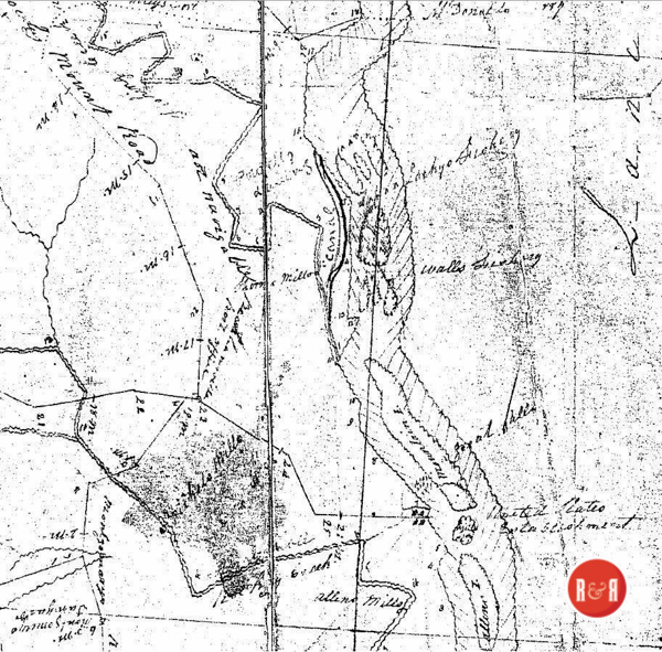
Note the 1818 Boyd Map of Great Falls, S.C. shows the Nichols Mills in the bottom left quadrant. Was this the workshop of Wm. Nichels the boat builder? Courtesy of the Mayhugh Collection – 2018
William Nickels was boat-write for the river men. He built all the boats used in navigating the river in bis day. When boat building was no longer a business, be opened a shop at bis home to repair wagon and all kinds of vehicles. This he did as long as be was able to do the work. He died in 1887 nearly 91 years of age. Mansel Hollis, probably, performed more manual labor than any man, white or black, in the country. He began as soon as be was able to do anything and continued until bis death at about eighty years of age. To recount the amount of labor done in one day by him on several occasions would almost stagger belief. His health was excellent until the last few years of bis life. He died in 1899. And left a considerable estate. Robert S. Nickels, was the best manager in a small way among us. He made the best living in the community on very slender resources and without much manual labor on bis part. He worked and managed to get eighteen bales of cotton ahead when it was worth about one hundred dollars per bale. After bis death in 1899, bis funeral and current farm expenses were settled sixteen bales could still be seen lying around. Since his death the oldest cotton ever sold in the county. His practice was to sell a bale when be needed some money and only then.
Thomas Bradshaw Lumpkin undoubtedly possessed the greatest mental caliber of any one in the community. With a collegiate training and such environments as would be most conductive to the greatest literary effort, it is difficult to conjecture what manner of man be would have made. With scarcely any education be enjoyed reading good literature and bis companion was fairly good. lie was a poet in the rough; be knew bow to make the lines jingle at their ends and to put sense in their middle. He wrote two poems which were notable; one v/as about a neighbor, which caused much anger, the other was on a meeting of Flint Hill Masonic lodge, in which a stanza was devoted to each officer and member present. The most prominent frailty of each was ridiculed most unmercifully. This was taken in the spirit of fun and caused no little merriment. No copy of either is now in existence or of any of is many squibs in doggerel. The old story of “Is it shelled”, which went the rounds of the press many years ago, was the product of his brain. His voice was the strongest I ever knew in a human being. On one occasion he stood on the platform of Robert Ford’s gin-house and called Fred, a negro boy, two or three times and told him to come to Mr. Ford’s gin-house and drive the gin. In the course of a half hour up walked Fred. He was asked, “why he came.” His reply was “Mas Brad called me to drive the gin,” and said he was gathering chinquapins at the “wash hole” when he was called. This was more than a mile on an air-line. Dr. I.S. Scott says he heard him once five miles, and it is said that he “hollered” once in the middle of the river and was heard ten miles down stream. Many of his quaint and witty sayings are still quoted and will be for days to come. He had an inexhaustible supply of anecdotes and no man ever told one in his presence that he could not tell one to match it and very likely a little better. He lived to be an old man.
(Information from: Names in South Carolina by C.H. Neuffer, Published by the S.C. Dept. of English, USC)
Historian Harvey S. Teal’s Post Office Data in S.C., states: “The Hazlewood Post Office ran from ca. 1831 – thru the Civil War. David McCalla served as the first Postmaster followed by Elijah McCalla. It was also called Midway Post Office.
Stay Connected
Explore history, houses, and stories across S.C. Your membership provides you with updates on regional topics, information on historic research, preservation, and monthly feature articles. But remember R&R wants to hear from you and assist in preserving your own family genealogy and memorabilia.
Visit the Southern Queries – Forum to receive assistance in answering questions, discuss genealogy, and enjoy exploring preservation topics with other members. Also listed are several history and genealogical researchers for hire.
User comments welcome — post at the bottom of this page.
Please enjoy this structure and all those listed in Roots and Recall. But remember each is private property. So view them from a distance or from a public area such as the sidewalk or public road.
Do you have information to share and preserve? Family, school, church, or other older photos and stories are welcome. Send them digitally through the “Share Your Story” link, so they too might be posted on Roots and Recall.
Thanks!

User comments always welcome - please post at the bottom of this page.


Share Your Comments & Feedback: