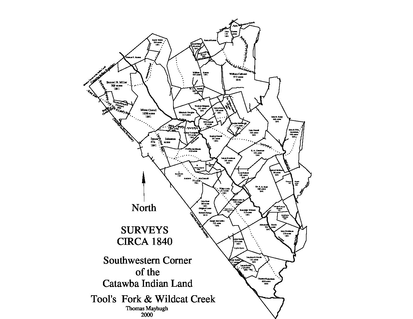
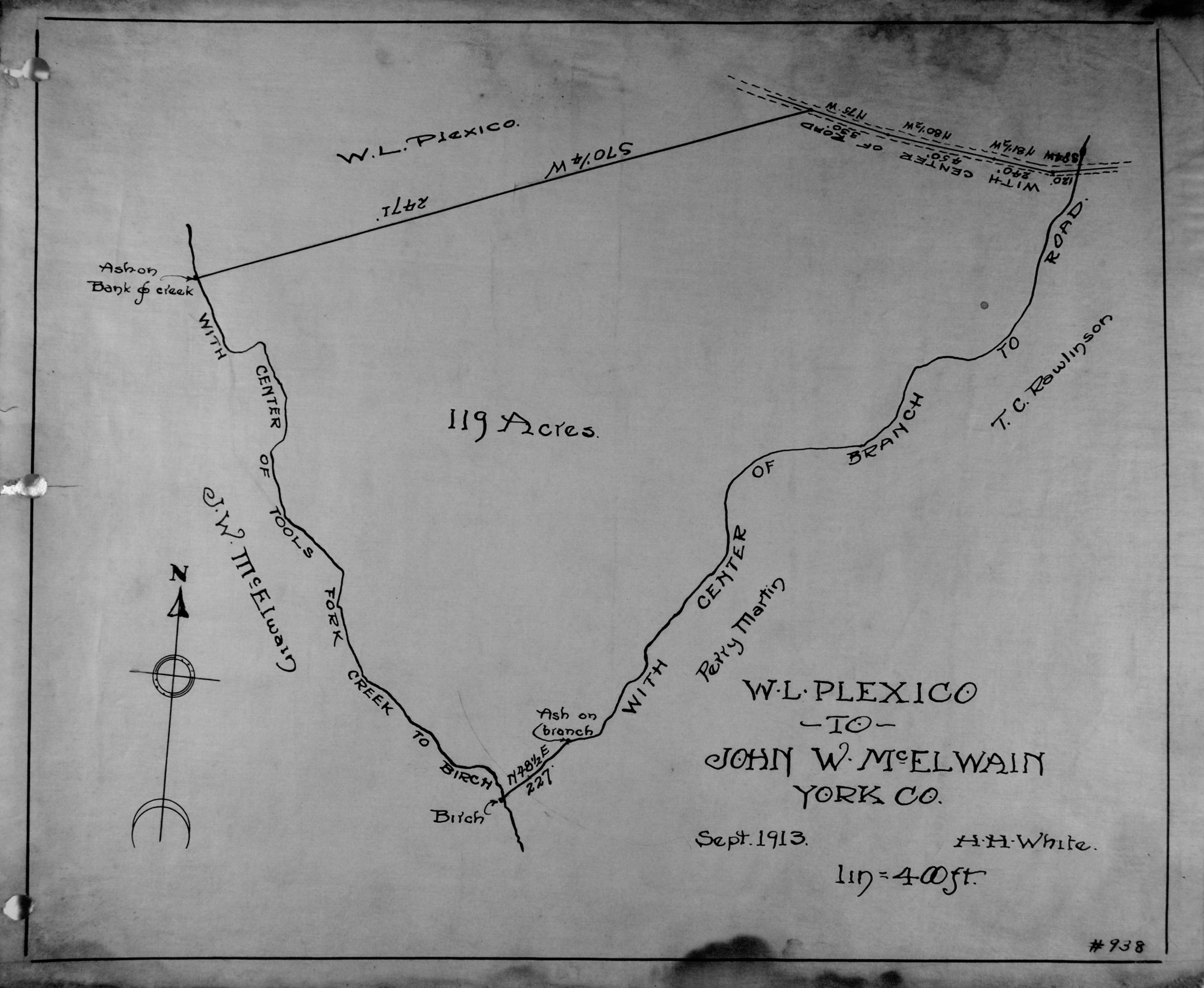
City Directories and History: This historic plat map shows the early landowners / leaseholders in and around the Wildcat Creek and Tools Fork areas south and southwest of Rock Hill, S.C. This map provides a searchable index of the names provided on this particular map. Search further under the enlargeable PDF, this page. Other Mayhugh maps may offer similar information but under a different title.
| A. James Johnson |
| A.S. Starr M.D. |
| Alexander Steele |
| Andrew McConnell |
| Armstrong Ford Road |
| Bennet Adkins |
| Black’s Branch |
| Charles McElwain |
| E.A. Crenshaw |
| Elizabeth Douglas |
| George R. Roach |
| Henry Cayton |
| Henry Youngblood |
| Isaac Smith |
| James Fewell |
| James Finley |
| James Steedman |
| John Anderson |
| John Barron or John B. Barron |
| John Fewell |
| John H. Barry |
| John Starr |
| John Steele |
| John Workman |
| Jonathan S. Steele |
| Joseph McCorkle |
| Keenan’s Branch |
| Lands’s Ford Road |
| Lucy Barnes |
| Minor Carroll |
| Phillip Sandifer |
| Randolph Withers |
| Richard Sadler |
| Road to Hill’s Ironworks |
| Samuel Barron |
| Samuel M. Roach |
| Samuel N. Miller |
| Stanley Fewell |
| Thomas Roach |
| Thomas Robertson |
| Thomas Simpson |
| Thomas Y. Barron |
| Tirzah Church Road |
| W.L. Harris |
| Wild Cat Creek |
| William Anderson |
| William Ardrey M.D. |
| William Cathcart |
| William Little |
| William Little Junior |
| Wylie Little |
*** See p. 69, Leasing Away a Nation PDF this page… for additional information on leaseholder: Isaac Smith and John McElwain dated Sept. 22, 1792. Also see Thomas Roach received lease for 122 acres from Thomas Spratt on Feb. 20, 1799, p. 69.
- Thomas Simpson takes lease of the lands on Fishing Creek formerly held by James Wilson – See p. 70, Leasing Away a Nation PDF this page… for additional information on leaseholder.
- William Nivens receives lease on 232 acres on East side of Tools Fork Creek, dated April 28, 1811, p. 73
- John Steele receives lease for 160 acres on Sept. 14, 1811, p. 74
- William Little Sr., takes lease on 236 acres Tools Fork of Fishing Creek, May 18, 1813, p. 76
- John B. Barron receives a lease of 845 acres on June 1, 1813, p. 76. This lease was taken over by Joseph Eakins on June 15, 1814, see p. 77.
- Thomas Simpson leases 126 acres on July 29, 1813, p. 76
- On Aug. 17, 1813 Thomas Bailey leased 242 acres along Tool’s Fork of Fishing Creek, p. 76
- Joseph McCorkle received a lease on 173 acres on Aug. 16, 1815, p. 77 and p. 78
- John Barron takes lease on 216 acres dated Jan. 25, 1816, p. 78
- William McCorkle took a lease of 290 acres on Wildcat Creek, dated Aug. 16, 1816, p. 78, later on July 1818, one Mr. John N. Henry takes this lease on 290 acres, p. 79
- Joel Bailes takes a lease dated May 21, 1818 on 108 acres about a mile above Harrisburg, on the east side of the Catawba River, p. 79
- John Barron receives lease on another 333 acres dated May 22, 1818, p. 79
- Thomas Ashcraft leases 88 acres on March 9, 1819, p. 79
- Samuel Steele leases 356 acres along Tool’s Fork of Fishing Creek, dated May 29, 1819, p. 80
- Francis McWaters or Francis McWatters takes lease on 164 acres along the Rocky Branch of Fishing Creek, dated July 8, 1819, p. 80
- John McElwain leases 148.5 acres on July 29, 1819, p. 80
- John Steele takes lease on 138 acres dated Aug. 16, 1821, p. 81
- On May 13, 1824 Agnes Cathcart takes lease as “widow” on 269 acres along Wildcat Creek, p. 83
Stay Connected
Explore history, houses, and stories across S.C. Your membership provides you with updates on regional topics, information on historic research, preservation, and monthly feature articles. But remember R&R wants to hear from you and assist in preserving your own family genealogy and memorabilia.
Visit the Southern Queries – Forum to receive assistance in answering questions, discuss genealogy, and enjoy exploring preservation topics with other members. Also listed are several history and genealogical researchers for hire.
User comments welcome — post at the bottom of this page.
Please enjoy this structure and all those listed in Roots and Recall. But remember each is private property. So view them from a distance or from a public area such as the sidewalk or public road.
Do you have information to share and preserve? Family, school, church, or other older photos and stories are welcome. Send them digitally through the “Share Your Story” link, so they too might be posted on Roots and Recall.
Thanks!

User comments always welcome - please post at the bottom of this page.


Share Your Comments & Feedback: