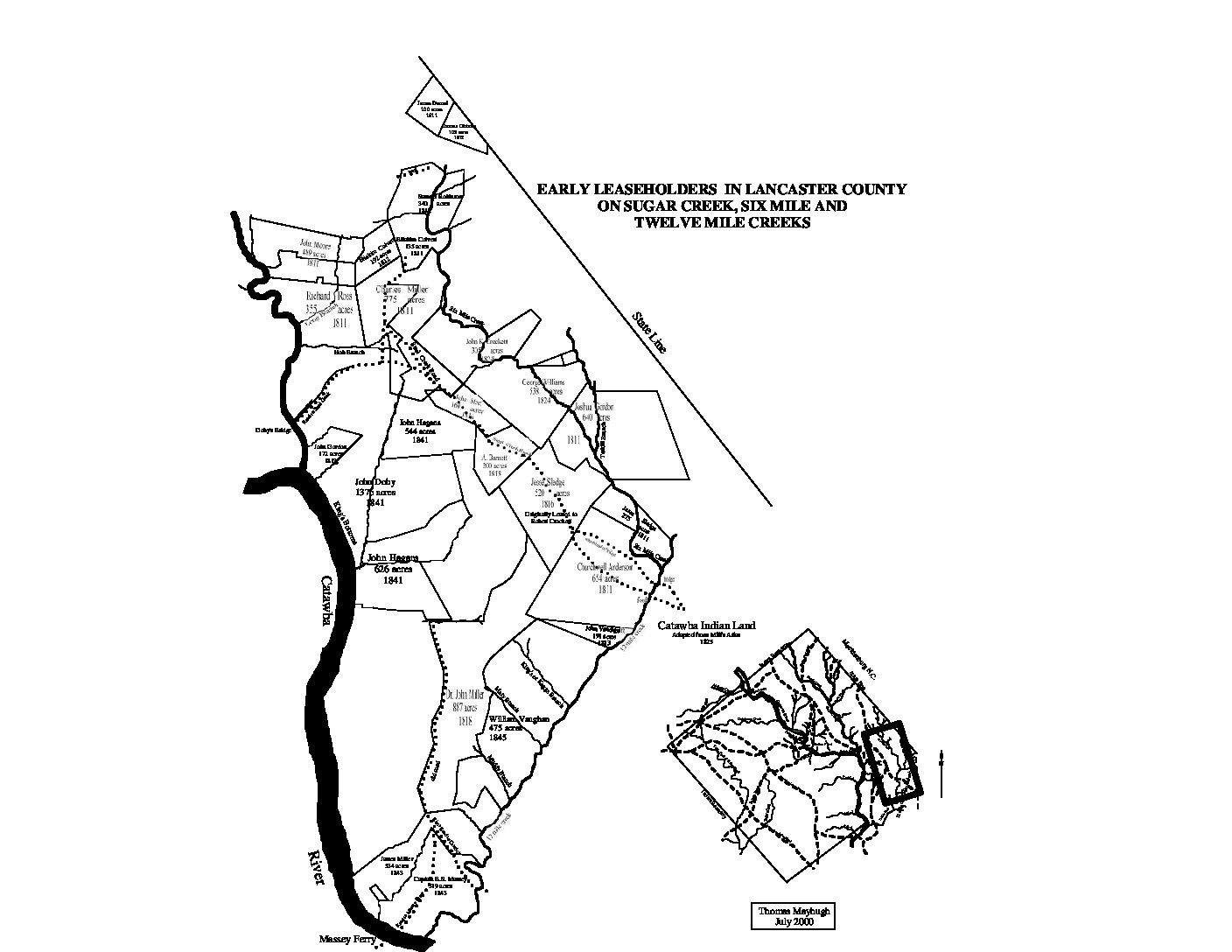
City Directories and History: This historic plat map shows the early landowners in and around Kings Bottom on the Catawba and the Six Mile Creek area south of Fort Mill, S.C. This map provides a searchable index of the names provided on this particular map. Search further under the enlargeable PDF, this page. Other Mayhugh maps may offer similar information but under a different title.
| 12 Mile Creek |
| A. Barnett |
| Charles Miller |
| Churchwell Anderson |
| Doby’s Bridge ***The Yorkville Enquirer reported on Feb. 20, 1889 – “Barber’s Bridge over Sugar Creek was washed away last Sept., in a flood and has now been replaced. It is the only connection between Fort Mill and a large part of Lancaster County.”
The YV Enquirer reported on Aug 1, 1894 – “Doby’s Bridge, across Sugar Creek, six miles east of Fort Mill, was carried away by the great flood last August. The contract has been awarded to Spratt Machine Company for a new bridge to be 145 ft long at a cost of $288. Lancaster County will pay half of the cost.” |
| Eliakim Colvert |
| George Williams |
| Hob Branch |
| James Darnel |
| Jesse Sledge |
| John Doby |
| John Gordon |
| John Hagans |
| John K. Crockett |
| John Miller M.D. |
| John Moore |
| John Steel |
| John Vandigrift |
| Joshua Gordon |
| King’s Bottoms |
| King’s or Keggs Branch |
| Long Branch |
| Mary Branch |
| Muddy Branch |
| Richard Ross |
| Robert Crockett |
| Samuel Robinson |
| Steele Creek Road |
| Tarkill Branch |
| Thomas Gibbons |
| William Vaughan |
Stay Connected
Explore history, houses, and stories across S.C. Your membership provides you with updates on regional topics, information on historic research, preservation, and monthly feature articles. But remember R&R wants to hear from you and assist in preserving your own family genealogy and memorabilia.
Visit the Southern Queries – Forum to receive assistance in answering questions, discuss genealogy, and enjoy exploring preservation topics with other members. Also listed are several history and genealogical researchers for hire.
User comments welcome — post at the bottom of this page.
Please enjoy this structure and all those listed in Roots and Recall. But remember each is private property. So view them from a distance or from a public area such as the sidewalk or public road.
Do you have information to share and preserve? Family, school, church, or other older photos and stories are welcome. Send them digitally through the “Share Your Story” link, so they too might be posted on Roots and Recall.
Thanks!
User comments always welcome - please post at the bottom of this page.


Share Your Comments & Feedback: