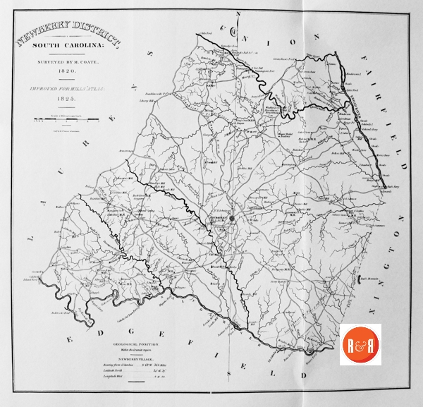

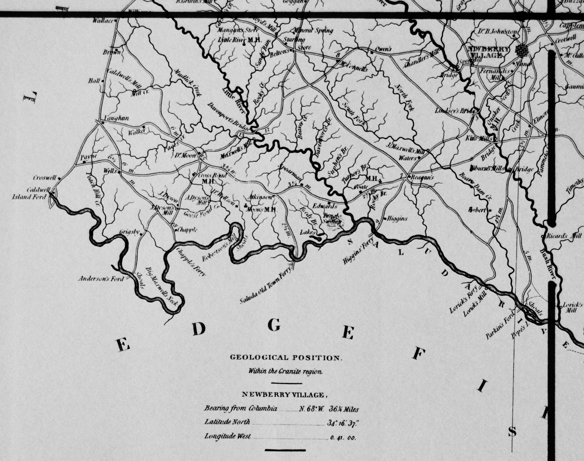
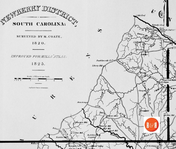
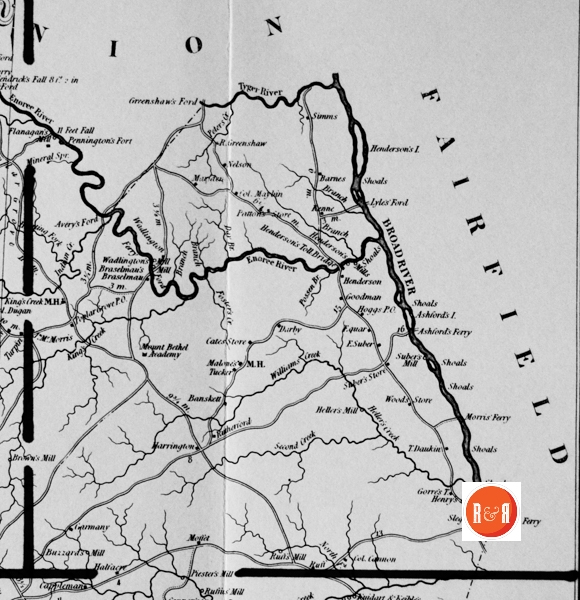
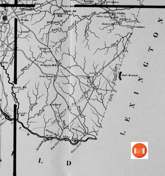
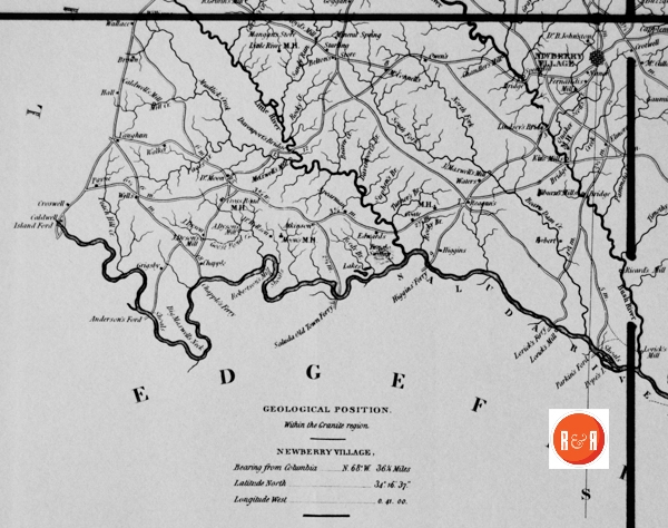
City Directories and History: Architect, Mr. Robert Mills was hired by the State of S.C. to create accurate maps of the state’s districts. In turn, he employed knowledgeable surveyors to survey the local areas, from which he created his finished maps of S.C., districts or counties. This resulted in accurate maps of roads, streams, and cities located in each. Click on the More Information / Enlargeable links, (found under the picture column), for an enlargeable county map, a history of Robert Mill’s survey of S.C. counties, written by Gene Waddell in 1980, an index to the names listed on the maps, and enlargeable quadrants for conducting in depth research.
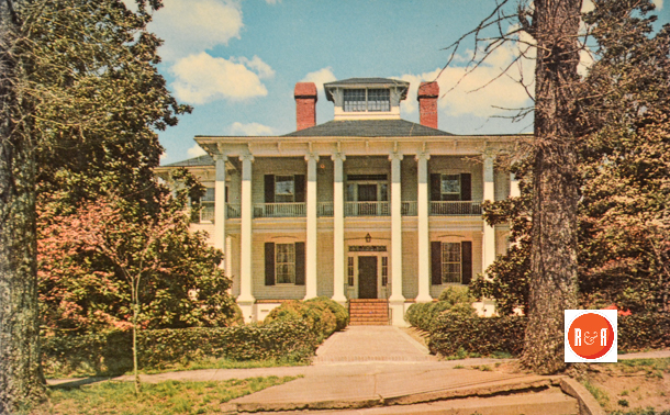
Postcard view of the Parr – Baker house, ca. 1820. Reported to have been designed by Robert Mill.
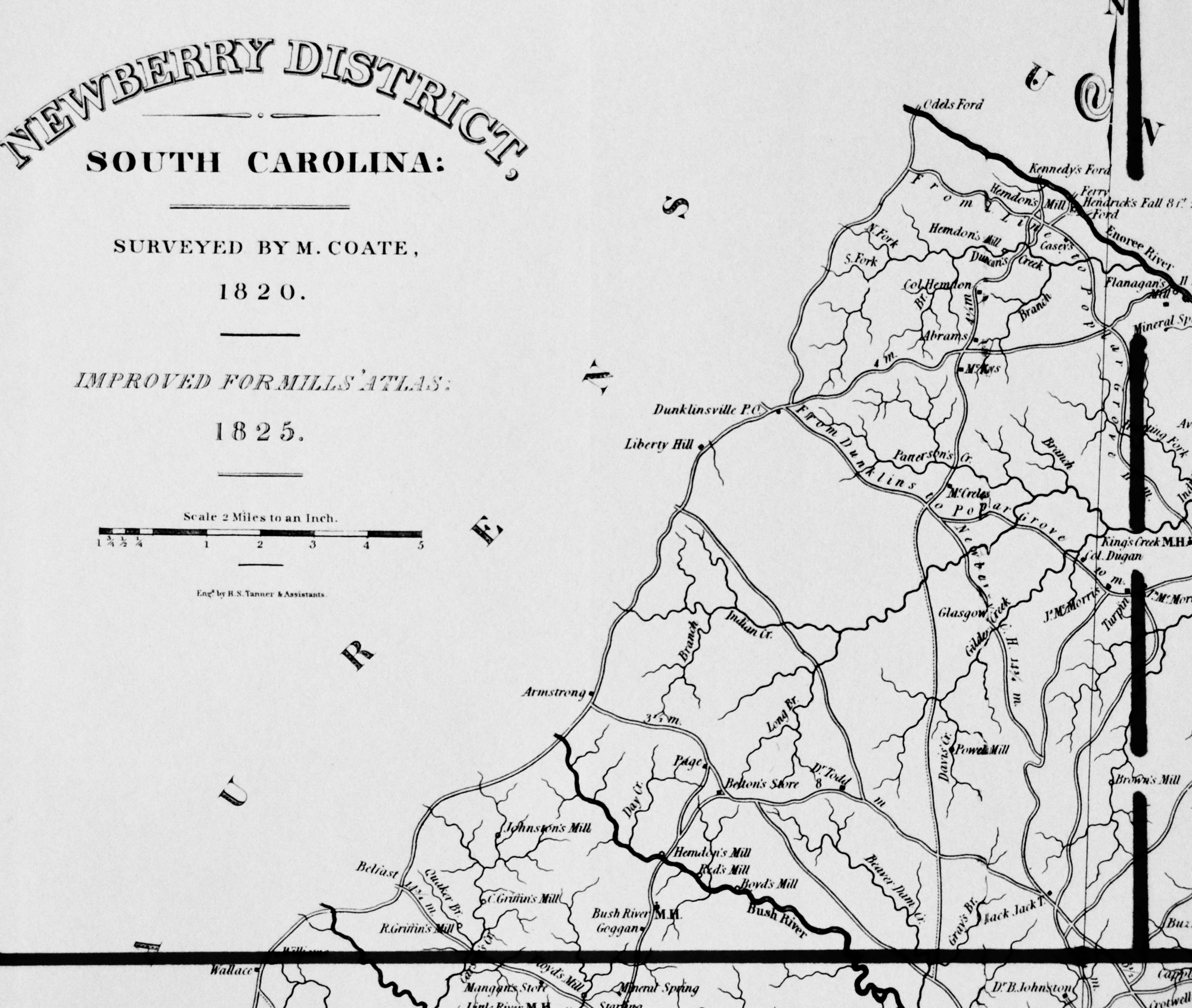
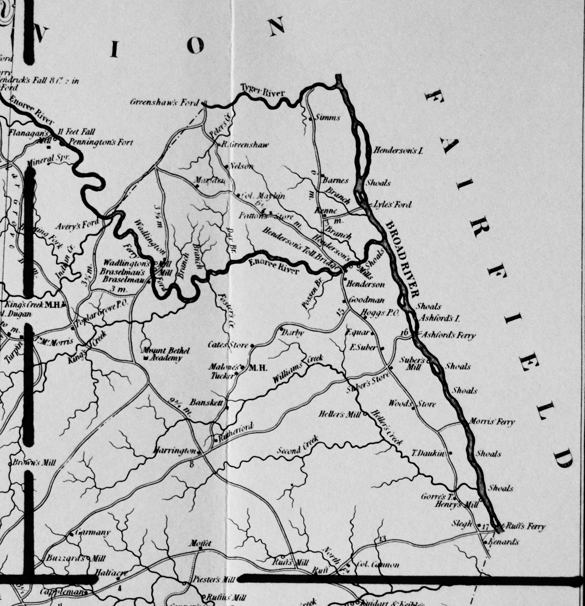
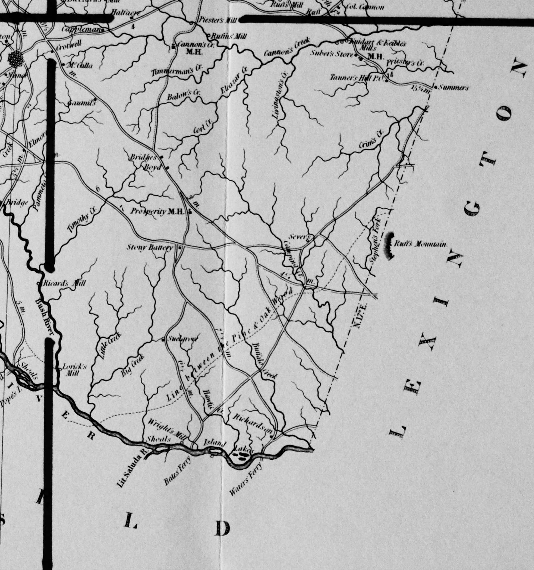
“Marmaduke Coate surveyed Lexington, Newberry, and Richland Districts. One thousand dollars was paid for the Lexington survey in August, 1819, and although the manuscript is unsigned, the 1821 printed version has his full name, the Atlas plate has “M. Coate,” and the inscriptions on the manuscript are in the same hand as his large-scale survey of Richland. The Lexington survey includes a street plan of Granby that is not reproduced in the Atlas. The 1821 edition was handsomely engraved by James Wood and printed by Wright and Smith. This version is more detailed than the Atlas plate, including distances between each change in road direction and additional place names. Coate was paid $800 for the Newberry map on 25 November, 1819. The manuscript is not known to survive, nor is a copy of the 1821 version that was also printed by Wright and Smith. On 28 April, 1820, Coate received $1,200 for the Richland survey. It has a minutely detailed plan of Columbia’s streets that is not reproduced in the Atlas. This survey and the other two required relatively little revision to be included in the Atlas.” Information from: Mill’s Atlas of South Carolina – 1825, Southern Historical Press, 1980
Courtesy of the Davie Beard Postcard Collection – 2017
R&R has also taken individual county maps and created a list of their recorded sites, allowing R&R’s users, faster access to historic data. Each of the More Information links opens items connected to the Mill’s map of this county. The last four are those related to Quadrants 1-4. Names within each quadrant are listed below and at the bottom of the page, is an alphabetical list, of all names shown in Newberry District, along with other counties in which the name also appears. Another excellent website to view the Mill’s maps is at Rumsey’s Maps.
Scroll down to view the alphabetical listing of names:
| 11 Feet Fall – N | Hawlie – N | Pennington – N |
| Abrams – Ch’f, N | Hawlie Creek – N | Pennington’s Fort – N |
| Anderson – A, Ch’f, E, Ge, Gr, H, Lan, | Heller – N | Peters Creek – N, Sp, W |
| Anderson’s Ford – N | Heller’s Creek – N | Piester – N |
| Armstrong – Gr, Lau, N, P, Su | Heller’s Mill – N | Piester’s Mill – N |
| Ashford – N, U | Henderson – Mar, N (2) | Pope – A, Ba, Ch’f, E, N |
| Ashford I. – N | Henderson’s I. – F, N | Popes I. – Be, N |
| Atkinson – N | Henderson’s Toll Bridge – N | Poplar Grove P.O. – N |
| Avery – N, U | Hendon – N | Powel – N |
| Avery’s Ford – N, U | Hendrick – Ch’f, N, U | Powell’s Mill – N |
| Balow – N | Henry – N, R, Y | Powels Mill – N |
| Balow’s Cr. – N | Henry Mill – N (2) | Priester – N |
| Banskett – N | Herndon – N (2) | Priester’s Creek – N |
| Barnes – N | Herndon, Col. – N | Prosperity M.H. – N |
| Bates – Ge, N, R | Herndon’s Mill – N (4) | Quaker Br. – N |
| Bazzard’s Mill – N | Herrington – N | Quaker M.H. – N |
| Beaver Creek – Ch’f (2), F, K, N, P | Higgins – N | Reagan -N |
| Belfast – N | Hilbums Mills – N | Reds Mill – N (2) |
| Belton – K, N | Hilburn – N | Reedy Branch – A, Ch’f, N, P |
| Belton’s Store – N | Hogg – Be, N | Ricard – N |
| Betton – F, N | Hoggs P.O. – N | Ricard’s Mill – N |
| Big Creek – E, N, O, P | Horbert – N | Richardson – Be, Ch, £, Lau, N, O, Su |
| Big Maxwell’s Neck – N | Huggins Ferry – N | Roberston – A, F, N, P |
| Black Jack T. – N | Hunting Fork – N | Robertson’s Mill – A, N |
| Boyd’s Mill – Lau, N | Indian Creek – Ch’f, Lau, N (2) | Rocky Branch – F, N, R, Y |
| Broad River – A, Be, Ch, F, Lex, N, R, Sp (2), | Island Ford – E, N, Sp | Rocky Creek – A (2), Ch (2), E (4), F, Lex, N, |
| Buffalo Creek – A, Ch’f, N, U, Y | Island Lakes – N | Ruff us – N |
| Bush River – N (3) | Johnson, Dr. – B, N | Ruff’s Mill – N (2) |
| Bush River M.H. – N | Johnston Mill – Co, N | Ruff-F, Lex, N |
| Buzzard – N | Keible – N | Ruffs Ferry – F, Lex, N |
| Caldwell – A, E, N, O | Kenard – N | Ruffs Mountain – N |
| Caldwell’s Mill – N | Kennedy – Cha, Co, F, N, U | Ruffus’ Mill – N |
| Camping Creek – Lex, N | Kennedy’s Ford – N, U | Rutherford – Gr, N |
| Cannon’s Creek – N (2) | Kenne-N | Saluda Old Town Ferry – E, N |
| Cappleman – N | King – A, Ch’f, Co, D, N, P | Sandy Run – Be, Co, Lex, N |
| Carson’s Creek – N | King Creek – Ba, N (2), Y | Scott’s Creek – E (3), N |
| Cate – N, O | King Creek M.H. – N | Second Creek – N |
| Cates Store – N | Kirk – Be, N | Sever -N |
| Cedar Creek – Ba (2), Ch’f, D, E (2), K, Lan, | Kirk’s Mills – N | Simms – Co, N |
| Cennon, Col. – N | Kuidart – N | Slegh – N |
| Chandle – Co, N, Su (2), U | Kuidart and Keible’s – N | South Fork – Lau (2), Lex, N (2), P (5) |
| Chandler’s Mill – N | Lake – Ba (2), Lex, N, O, R (6) | Spearman – N |
| Chappie – N | Laurenes – Gr, N, Sp, U | Speer’s Mill – N (2) |
| Chappie’s Ferry – N | Lexington – E, F, N, O, R | Speery -N |
| Coate – N | Liberty Hill – E, Lau, N | Starling – N |
| Corl Creek – N | Lindsay – N | Stephen – Lau, N |
| Creek – N | Lindsey’s Bridge – N | Stephen’s Fork – N |
| Croswell – N | Line between the Pin and Oakwood * Lex, N | Stony Battery – N |
| Cross Roads M.H. – N | Little Creek – A, Lau (2), N | Suber – N |
| Crostwell – N | Little River – A (2), F, H, Lau, Lex, N, P, R, | Suber, E. – N |
| D Gilders Creek – Gr, N (2) | Little River M. – H, N | Suber’s Mill – N (2) |
| Darby – Ch, N, 0 | Little Saluda River – E (2), N | Suber’s Store – N |
| Daukin, J. – N | Livingston – N, O | Suelgrove – N |
| Davenport – N | Livingston’s Creek – N | Summers – Ge, N |
| Davenport’s Bridge – N | Long Branch – N, Su | Suphen’s Br. – N |
| Davis Creek – N (2) | Lorick – E, Lex, N | Tanner – N, Sp |
| Davis, Jn. – N, Su (2) | Lorick’s Ferry – N | Tanner’s Hill P.O. – N |
| Day Br. – N | Loricks Mill – N | Timmerman – N |
| Day Creek – N | Lyles – F, N | Timmerman’s Creek – N |
| Dugan, Col. – N | Lyles’ Ford – F, N | Timothy Creek – N |
| Duncan’s Creek – Lau, N | M.H. – Ba (11), E (4), F, Gr, H (6), Lan, Lex, | Todd, Dr. – N |
| Dunklinsville P.O. – N | Malone – N | Tucker – A (2), Ge (3), N, P, R |
| Dyson’s, J., Mill – N | Mangan’s Store – N | Tugado Swamp – N |
| Dyson’s, A., Mill – N | Mariden – N | Turner – N |
| Edgefield – Lex, N, O | Maxwell – Ba, E, N | Turner Br. – N |
| Eleazar Creek – N | Maxwell Mill – N | Turpin – N |
| Ennoree River – Gr, Lau, N (2), Sp (2), U | Maxwell’s, J.: Mill – N | Tyger River – F, N, Sp, U |
| Fairfield – K, Lan, Lex, N, R, U | Maybin, Col. – N | Union – Ch, F, Lau, N, Sp, Y |
| Femandis Mill – N | McCalla – Ch, N | Vaughan – Gr, Lau, N, Su (2) |
| Ferry – Be, Cha (2), Co, K (4), Lan, N (2), U,Y(S) | McConnell – N, W | Wadlington – N |
| Flanagan – N | McCreless – N | Wadlington’s Mill – N |
| Flanagan’s Mill – N | McDonald – Ch, Ch’f (2), K, Lan, R | Walker – Ba, Ch, Co, E, H, N, O |
| Floyd – H, Mar, N | McKenny – Gr, Lan (3) | Wallace – Be, Cha, Ch, Co, Lan, N |
| Floyd’s Mill – N | McMorris, James – N | Waters – Ba, E, N, W |
| Ford – K, Lex, N, R (2), U (2) | McMorris, John – N | Waters Ferry – E, N |
| Foster – Cha, Lau, N, Sp | Mineal Spring – D, Ge, K (2), Lan, Lex, N (2), | Wells – Be, Cha, N, O |
| Foster’s Creek – Cha, N | Moffet – N | Wellson, Dr. – N |
| From Dunklins to Newberry C.H. – N (2) | Moon, Dr. – N | Williams – N, Su |
| From Dunklins to Poplar Grove – N | Moon’s M.H. – N | Williams Creek – N |
| From L. Line to Poplar Grove – N | Morris – Co (2), F, Ge, N | Wood – Ba, N, R |
| Garmeny – N | Morris Ferry – F, N | Wright – A, Lau, N, Su, U |
| Gaumils – N | Mount Bethel Academy – N | |
| Gilder – Gr, N | Mudlick Creek – Lau, N | |
| Glasgow – N (2) | Nance – N | |
| Goggan – N | Nelson – Cha, Ch, N, O, R, Su, W | |
| Goodman – A, Ch:f, N | Newberry Village – N | |
| Goose Pond Creek – N | Odel – N, U | |
| Gorre, T. – N | Odel’s Ford – N | |
| Gray’s Br. – N | Owen – Ba, Be, Ch, N | |
| Greenshaw – N, U | Page – H, Mar, N | |
| Greenshaw, R. – N | Pages Creek – N | |
| Greenshaw’s Ford – N, U | Pammeto Creek – N | |
| Griffin, C. – N | Parkins Ford – E, N | |
| Griffin, R. – N | Parkins – N | |
| Griffin’s, C., Mill – N | Patterson – A, N, R | |
| Griffin’s, R., Mill – N | Patterson’s Creek – N | |
| Grigsby – N | Patton – N | |
| Halfacre – N | Payne -N | |
| Hall – Ch, K, Lau (2), N, O, Su | Peach Hill Creek – N |
Stony Battery – In this farming area near Prosperity, Lt. Colonel William Washington defeated and dispersed an army of Tories. The name of the section comes from the stones which lie on the surface of the ground in large quantities. These are common flint rocks. Washington’s battery is believed to have been built of these rocks. A humorous story is associated with this community. A physician there had a large and lucrative practice. But he decided that he could make himself richer by distilling peaches into brandy. He planted about twenty acres in peach trees but just about the time the trees began to bear he was converted and joined the Church. He cut down his peach orchard and became a powerful preacher. In this neighborhood there is now a flourishing in-dustrial plant. Several large churches are in the vicinity and many beautiful homes with a citizenry devoted to progress.
(Information from: Names in South Carolina by C.H. Neuffer, Published by the S.C. Dept. of English, USC)
Moon’s Meeting House, mentioned in the notice of Rev. William Harmon, is not far, or was not far, from Chappells. When this writer first knew that country that house was standing and was used as a place of worship. In fact I think I once attended divine service in that house. By the way, writing of Moon’s Meeting House makes me think of it.
(Information from: The Annals of Newberry Co., SC – O’Neall and Chapman, Aull and Houseal Publishers – 1892)
“To the memory of William Gregg, Sr., who departed this life on the 10th day of November, 1810, aged seventy-one years.”
“Also, of Mary Spence, wife of Samuel Spence and daughter of William and Jane Gregg, who departed this life on the 14th day of September, 1823, in the fortieth year of her age.” “Likewise, of Jane Gregg, who departed this life on the 14th day of September, 1823. aged eighty-four years.”
Mrs. Mary Spence, here mentioned as the daughter of William and Jane Gregg, and wife of Samuel Spence, had for her first husband Samuel McCalla, Esq., who came to this country and settled on the land afterwards owned by Major James Graham, then by Chancellor Job Johnstone, now by his son, J. Malcolm Johnstone. Samuel McCalla was compelled to leave Ireland about 1798 because of the part taken by him in some political troubles in that unhappy country. Having to leave the country to avoid arrest, he left his wife and little son Robert, only two or three years old. He seems to have come directly to Newberry and settled on the above-mentioned place, his wife and son Robert not coming to America until 1817. The son he had left a sportive boy was now a young man of about twenty one years. Mrs. Mary McCalla and son Robert sailed from Belfast, Ireland, October 12th, 1817, on the ship Cyrus, commanded by Captain Gassard, and landed at Charleston, S. C., November, 30th, 1817.
(Information from: The Annals of Newberry Co., SC – O’Neall and Chapman, Aull and Houseal Publishers – 1892)
See #7 Pennington’s Fort information link: Newberry County Historic Sites and Structures
The Yorkville Enquirer reported on March 9, 1892 – “Mr. L.H. Chandler of Newberry has in his possession perhaps the oldest clock in the country. His family brought it to Newberry Co., from N.J. in 1757 and it had been in the family long before that.” (It is unclear where Mr. Chandler lived in Newberry Co.,)
Stay Connected
Explore history, houses, and stories across S.C. Your membership provides you with updates on regional topics, information on historic research, preservation, and monthly feature articles. But remember R&R wants to hear from you and assist in preserving your own family genealogy and memorabilia.
Visit the Southern Queries – Forum to receive assistance in answering questions, discuss genealogy, and enjoy exploring preservation topics with other members. Also listed are several history and genealogical researchers for hire.
User comments welcome — post at the bottom of this page.
R&R HISTORY LINK: Wm. Kelly the bargeman delivered cotton for C.W. Hogg (Note Hogg’s P.O) in 1852
Please enjoy this structure and all those listed in Roots and Recall. But remember each is private property. So view them from a distance or from a public area such as the sidewalk or public road.
Do you have information to share and preserve? Family, school, church, or other older photos and stories are welcome. Send them digitally through the “Share Your Story” link, so they too might be posted on Roots and Recall.
Thanks!

User comments always welcome - please post at the bottom of this page.


Share Your Comments & Feedback: