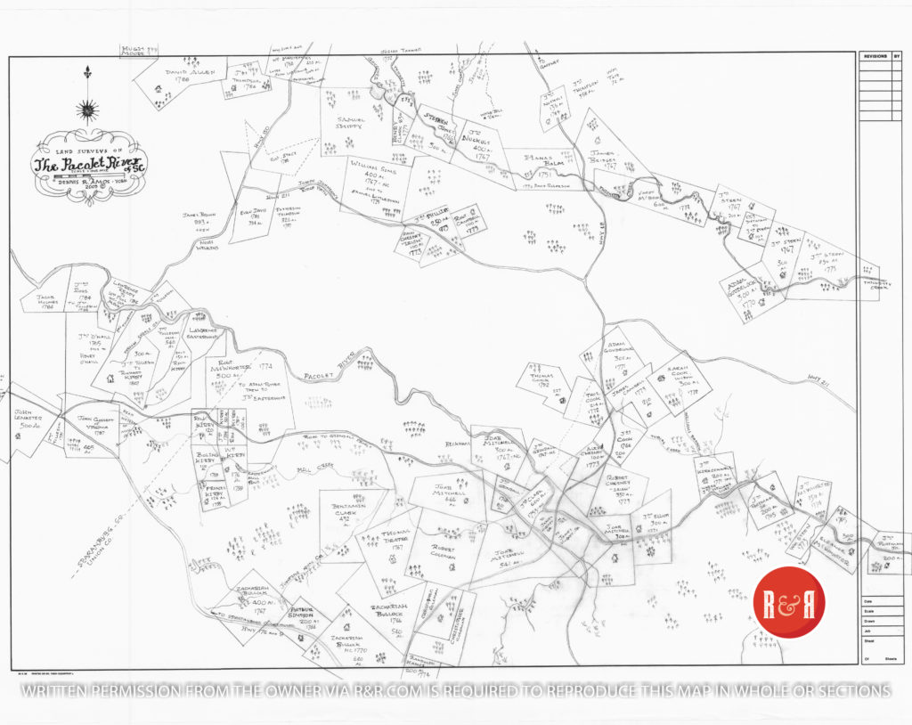
City Directories and History: The land grant plat map, part of the Amos Collection, displays mid 18th century land grants along the Pacolet River in upcountry S.C. See enlargeable PDF this page and the accompanying spreadsheet of related data.
CREEKS AND GEOGRAPHICAL FEATURES OF THE PACLOET RIVER AREA
SHOALS
A shoal is a natural land form that can be a sand bar, gravel bar, or solid rock in shallow water. In the Pacolet river area there were a number of shoals. These were convenient places to ford the river. The wider the shoal, the slower the water, and after rains, would not increase in depth drastically.
GRINDALL SHOALS– was widely known because it was the best place to ford without removing the entire contents of the wagon. Generally a loaded wagon bogged down in the mud, however, at Grindall’s shoals, it was solid rock. It was a very wide crossing and even the banks were easy to maneuver. This became known as Grindall shoals (also Grindel and other variations).
It was such an active and well-traveled crossing that there was a community there. John Grindall had a trading post and sold to hunters, the over-the-mountain men, and Indian traders. Trappers would bring furs and skins, then sell or exchange for goods. Beaver was especially valuable for making top hats for gentlemen in Charleston and Britain.
SEE ENLARGEABLE PDF OF THE MAP – UNDER THE PRIMARY IMAGE
Grindall had a fish weir for trapping fish. Fish and meats were salted for preservation. He also had a mill, and in addition to milling various grains, he could manufacture gun powder. There are still foundations there showing his many warehouses where he stored his goods. He shipped furs and salted meats on boats that floated down the Pacolet, and eventually to Charleston. His men would return with finished goods to be sold in the store.
It was on the bluff above Grindall’s where General Daniel Morgan camped for several weeks in the winter prior to the Battle of the Cowpens. Thus Grindall shoals played a pivotal role in supplying General Morgan with gun powder and food. And that was not all. The geography there is still most unusual as the road is between two high gravely shoal banks, and only 2 horses could ride side-by-side. Except for the road from the river, the flat land is marsh-like and virtually impassable. Thus, it was perfect protection from ambush or any surprise attack. Morgan showed brilliance in his selection of Grindall Shoals for both protection and access to food and strategically important gun powder.
Unfortunately, the tragic flooding of the Pacolet in June of 1903 covered up the shoals with several feet of mud and it can no longer be seen. With the building of bridges, the old roadway was by-passed and now highway 18 has kept it all but hidden.
CARROL’S SHOALS (also Carroll) – This was the original name given to what is now Grindall Shoals. It was named for Richard Carol, a very early settler around 1751. The name Carol’s Shoals was described on Grindall’s land entry.
SWIFT SHOALS– These shoals were cited as “nearby” on John Grindall’s SC Memorial (to formalize a North Carolina grant that was in error) as being nearby.
PETTET SHOALS– While these are not on the map, they can be pointed out. (Note the plat to John Kirkconnel on the north side of the Pacolet, a few miles below Grindall.) At the western boundary of where his border meets the Pacolet, it was called Pettet (or Pettit) Shoals.
SKULL SHOALS – While not shown, the skull shoals are just a bit further downstream on the Pacolet, at a complete horseshoe bend.
TROUGH (OR TROFT) SHOALS – A mill was established here and later the name changed to Pacolet Mills, SC. The Yorkville Enquirer reported on April 24, 1889 – “Mr. William Strain has returned from a months visit to Trough Shoals Factory. Many of the operatives are from western York and norther Union Counties.” (Pacolet Mills is in Spartanburg Co., S.C.)
EASTERWOOD SHOALS – Named for Lawrence Easterwood. This shoal was where Tarleton crossed the Pacolet when learning it was unguarded. This allowed him to by-pass Grindall Shoals. (Note this is shown on MILLS Atlas of 1825). Lawrence Easterwood had several large land holdings, although no original grants.
CREEKS
GOUCHER CREEK – Named after a settler, Henry Goucher. He did not apply for a land grant and was probably a “squatter” that moved on when the population increased. There was a “Henry Goucher” after the revolution that applied for land in the Pendleton area. It could have been him or his son. It is not a common name.
WILLIAMS CREEK – Named after John Williams who first applied for a survey in 1770. His plat is not shown as most of it was taken up by John Kirkconnel, a surveyor. Williams creek flows into the Pacolet through Kirkconnel’s property.
TOBIAS CREEK – Tobias Creek flows into Williams Creek. As this is where Pettit Shoals is located, it is interesting to note that on a 1787 plat for John McWhorter near this area, a copy of the plat was said to be “delivered to Tobias Pettet”.
MILL CREEK – As early as 1767 this was known as CLARKS MILL CREEK. Due to the fall line of the water, there were several mills on MILL CR. One survey noted the number of feet drop such as “in 6 chains (length of 396 ft.) the drop is 6 feet, 6 inches”.
LUKEROY BRANCH – Named for an earlier landowner named John Lukeroy. This was near the Wofford Iron Works and a mine. This branch also flows through Michael McGaughy’s plat.
| NAMES | DATE | ACRES | Present County | ORIGIN of PLAT | GEOGRAPHIC | OTHER INFORMATION |
| Aldridge, William | 1784 | 200 | Spartbg | SC State Plat | Packolet R, borders | 1787 sold to Mathew McBee who bordered his property. |
| Allen, David | 1788 | 543 | Cherokee | SC State Plat | Goucher Cr, both sides | bordered his own, and Wm Anderson |
| Balm, Hanas | 1751 | 400 | Cherokee | NC, Meck. Co. | Thicketty Cr., main, both sides | The earliest known plat in this district. Re-surveyed in 1767 due to loss of all corners except beginning. |
| Beckham, John Jr. | 1792 | 692 | Spartbg | SC State Plat | Ridge betw Pacolet & Thicketty | on wagon road |
| Bridges, James | 1767 | 375 | Cherokee | NC, Meck. Co. | At the mouth of Mincom Cr where it flows into Thicketty | borders Haunas Balme’s, chain carries Charles Robeson, Micajah Collins |
| Brown, David | 1767 | 150 | Spartbg | SC, Colonial plat | Maye’s Cr of Fair Forest | Bounty (land grant for soldiers pay) |
| Brown, David | 1787 | 100 | Spartbg | SC State Plat | Maye’s Cr of Fair Forest | borders his other plat |
| Brown, Isaac | 1805 | 53 | Spartbg | SC State Plat | Branches of Fair Forest | borders David Brown |
| Brown, James | 1793 | 943 | Cherokee | SC State Plat | Ridge betw Pacolet & Thicketty | borders James Brown land |
| Bullock, Zachariah | 1766 | 540 | Union | NC, Meck. Co. | Jumping Run Creek | chain carriers Thomas Draper, Randolph Haymes |
| Bullock, Zachariah | 1767 | 400 | Union | NC, Meck. Co. | Jumping Run Creek | borders another of his plats, chain carriers John Hail, Dan Bush |
| Bullock, Zachariah | 1770 | 640 | Union | NC, Tryon Co. | Spartanburgh rd, Jumping Run Cr. | Chain carriers, Thomas Draper, John Haile, borders his own and Randolph Hames, on Spartbg road |
| Campbell, James | 1773 | 200 | Cherokee | SC Colonial plat | Tobias Creek, to Pacolet | borders Thomas Cook |
| Campbell, Robert | 1773 | 300 | Cherokee | SC Colonial plat | Ridge betw Pacolet & Thicketty | borders James Phillips |
| Chesney, Alexander | 1773 | 100 | Cherokee | SC, Colonial plat | Branch of Pacolet | borders John Grindall |
| Chesney, Ann | 1773 | 100 | Cherokee | SC, Colonial plat | small branch of Pacolet | Irish allocation (for Irish Protestants) |
| Chesney, Robert | 1773 | 350 | Cherokee | SC, Colonial plat | small branches of Pacolet | Irish allocation (for Irish Protestants), borders Grindall & John Williams |
| Clark, Benjamin | 1786 | 435 | Union | SC court case | Mill Cr, flows to Pacolet R | (map incorrectly stated 432 acres). Included land from Jacob Green, John Kirkconnel, and Anglica Mitchell. |
| Clark, Henry | 1771 | 83 | Cherokee | SC Colonial plat | Thicketty Cr., south side | borders Stephen Jones |
| Clark, John | 1752 | 600 | Union | NC, Anson Co. | Pacolet, both sides | 1763 sold to James Hughey, Sr. |
| Coleman, Christopher | 1766 | 200 | Union | NC, Meck. Co. | Mill Cr | joining Robert Coleman, chain carriers Thomas Draper, Randolph Hames |
| Coleman, Christopher | 1767 | 200 | Union | NC, Meck. Co. | Mill Cr | joining his other plat, chain carriers William Coleman, Joab Mitchell |
| Coleman, Robert | 1766 | 600 | Union | NC, Meck. Co. | Mill Cr | joining Thomas Draper |
| Cook, James | 1766 | 200 | Cherokee | NC, Meck. Co. | Tobias Creek, both forks of, to Pacolet | chain carriers John Grandel, George Dickey |
| Cook, Sarah | 1772 | 300 | Cherokee | SC Colonial plat | William Br, flows to Pacolet | Widow. Land memorialized to John Ellison in 1773. |
| Cook, Thomas | 1772 | 214 | Cherokee | SC Colonial plat | ridge road (hwy 18) | borders Adam Goudelock |
| Cook, Thomas | 1792 | 227 | Cherokee | SC State Plat | borders his own | |
| Cruse, Richard | 1773 | 350 | Spartbg | SC Colonial plat | Harris Br, of Fair Forest Cr | |
| Davis, Evan | 1786 | 394 | Cherokee | SC State Plat | on ridge path (Hwy 211) | |
| Dietmar, Henry | 1763 | 100 | Cherokee | SC Colonial plat | At Thicketty Cr | sold to John Steen, who bordered this plat |
| Donaldson, Hugh | 1784 | 340 | Spartbg | SC State Plat | Harris Br, of Fair Forest Cr | borders George McCarter |
| Draper, Thomas | 1767 | 451 | Union | NC, Meck. Co. | Mill Cr of Pacolet | borders Coleman on the east side of Draper’s plat |
| Easterwood, Lawrence | 1779 | 200 | purchased | Pacolet R, borders | Original grant to Daid Park in 1754, sold to Michael Crawford in 1775, who sold to Easterwood. | |
| Elliot, John | 1771 | 300 | Union | NC, Tryon Co. | Pacolet R, both sides | borders John Grindall’s line |
| Gossett, John | 1787 | 405 | Union | purchased from the Grantee | Branches of Fair Forest | Sold by Seth Lewis, grantee |
| Goudelock, Adam | 1767 | 200 | Cherokee | NC, Meck. Co. | Thicketty Cr., reedy branches of, both sides | (map incorrectly stated 300 acres). Chain carriers Joseph Jolley and John Goudelock. |
| Goudelock, Adam | 1770 | 300 | Cherokee | NC, Tryon | Ridge betw Pacolet & Thicketty | chain carriers John Nuckols, John Goudelock |
| Gout, Joseph | 1784 | 100 | Spartbg | SC State Plat | Pacolet, north of | (Probably Gault) |
| Grindell, John | 1767 | 250 | both | NC, Meck. Co. | Pacolet R, both sides | on Carrol’s shoals. When memorialized in SC in 1775, it was 150 ac between “Swift Shoals” and Carrol’s Shoals”. |
| Grindell, John | 1768 | 80 | Union | SC Memorial | Pacolet R, both sides | on his other corner |
| Hames, Randolph | 1771 | 200 | Union | NC, Tryon Co. | Mill Cr, south fork of | Chain carriers, Christopher Coleman, Phillop (sic) Coleman, border Coleman & Bullocks lines |
| Holmes, Jacob | 1784 | 200 | Spartbg | SC State Plat | Pacolet R, borders | borders Judge Savage |
| Jones, Stephan | 1766 | 300 | Cherokee | SC Memorial | Thicketty Cr., main, both sides, mouth of Jones Cr. | sold in 1771 to Henry Clark, who bordered his property |
| Joy, Richard | 1785 | 200 | Cherokee | SC State Plat | Farmers Branch of Thicketty | |
| Kirby, Boling | 1799 | 100 | Union | purchased | ||
| Kirby, Frances | 1799 | 124 | Union | purchased | ||
| Kirby, John | 1794 | 50 | Union | purchased | ||
| Kirby, Richard | 1807 | 350 | Spartbg | purchased from Grantee | Pacolet, south of | Sold by John Tolleson |
| Kirby, William | 1799 | 176 | Union | purchased | ||
| Kirkconnel, John | 1771 | 200 | Union | NC, Tryon Co. | Pacolet, borders | lives on improvements where John Williams lives. Chain Carries Thomas Nichols & John Elliott |
| Lemaster, John | 1791 | 291 | Spartbg | purchased from Grantee | waters of Storey’s Mill Cr | sub-divided plat of James McCool |
| Lewis, Seth | 1784 | 405 | Spartbg | SC State Plat | small branches of Fair Forest | sold to John Gossett |
| Marchbanks, William | 1766 | 400 | Cherokee | NC, Meck. Co. | Goucher Cr, both sides | Co-owner, William Sims. Hain carries James Fanning, Hugh Wilson. Sold 245 acres to John Lipscomb in 1791. William Wilkins would later own the remainder. |
| McBee, Mathew | 1784 | 100 | Spartbg | SC State Plat | Packolet R, borders | Mouth of Lawson Forks at Pacolet R |
| McBee, Vardy | 1772 | 600 | Cherokee | SC court case | Thicketty Cr., main, both sides | Loose Colonial plats |
| McCarter, George | 1784 | 300 | Spartbg | SC State Plat | Harris Br, of Fair Forest Cr | |
| McCool, John | 1788 | 500 | Spartbg | SC State Plat | Storey’s Mill Cr | sub-divided to John Lemasters and John Vandiver |
| McGaughy, Michael | 1788 | 600 | Spartbg | SC State Plat | Lukeroy Br., flows to Richland Cr | part of Judge Edward Savage’s land confiscation of 3 plats, totalling 1000 acres (known as Forfeited Land) |
| McWhorter, Elenor | 1765 | 300 | Union | NC, Meck. Co. | Pacolet R, both sides | Irish allocation, chain carriers Joihn Portman, George McWhorter |
| McWhorter, John | 1774 | 150 | Union | SC Colonial plat | Pacolet R, borders | |
| McWhoter, Robert | 1774 | 500 | Union | SC Colinal plat | Pacolet, borders | borders Anelia Mitchell |
| Mitchell, Angelica | 1767 | 600 | NC, Meck. Co. | head of Clark’s Mill Cr | Chain carriers Joab Mitchell, John Hail. Sub-divided to Kirby Family | |
| Mitchell, Joab | 1766 | 541 | Union | NC, Meck. Co. | Mill Creek of Pacolet R | borders Robert Coleman |
| Mitchell, Joab | 1767 | 300 | Union | NC, Meck. Co. | Pacolet, both sides | Chain carriers, Charles Robinson, Johhn Beckham. borders Gindal’s |
| Mitchell, Joab | 1767 | 446 | Union | NC, Meck. Co. | one corner on road to Spartbg | Includes James Wilson’s improvement. Along Draper’s line. |
| Mitchell, Joab | 1768 | 300 | Union | SC Colonial plat | Pacolet R, both sides | Original plat in Mecklenburg, NC. |
| Moore, Hugh | 1771 | 100 | Cherokee | NC, Tryon Co. | Thicketty Cr, Bullocks fork | Chain carriers, George Underwood, Isham Saffold |
| Nail, John | 1785 | 506 | Spartbg | SC State Plat | branches to Trough shoals of Pacolet R | sold to John Stone, 1797 |
| Neale, John | 1784 | 368 | Union | SC State Plat | ||
| Nuckols, John | 1767 | 400 | Cherokee | NC, Meck. Co | Thicketty Cr., main, both sides | chain carriers Joab Mitchell, Stephen Jones |
| Nuckols, John | 1784 | 136 | Cherokee | SC State Plat | waters of Thicketty Cr | borders James Robinson & John Nuckols |
| Petty, Joshua | 1789 | 600 | Cherokee | SC State Plat | Thicketty Cr | borders Samuel Shippy |
| Phillips, James | 1773 | 250 | Cherokee | SC Colonial plat | on ridge path (Hwy 211) | sold to Samuel Littlejohn |
| Portman, John | 1765 | 200 | Union | NC, Meck. Co. | Pacolet, both sides | chain carriers James Byars, John Moore. Including his improvements. |
| Portman, John, Jr. | 1767 | 200 | Union | NC, Meck. Co. | Pacolet R, both sides | borders Widow (Elenor) McWhorter |
| Potter, Adam | 1787 | 957 | Union | SC State Plat | Pacolet, south of | |
| Reddy, Lawrence | 1784 | 150 | Spartbg | SC State Plat | Pacolet R, borders | includes mouth of Tumbling Shoals, sold 1786 to Willliam Poole |
| Ross, John | 1784 | 200 | Spartbg | SC State Plat | Pacolet R, borders | borders Holmes |
| Shippy, Samuel | 1801 | 536 | Cherokee | SC State Plat | Thicketty Cr, main, Goucher Cr. | |
| Simpson, Arthur | 1766 | 200 | Union | NC, Meck. Co. | Jumping Run Creek, branches of | Chain carriers James Mayes, John Foster. On road to Spartanburgh |
| Simpson, Arthur | 1784 | 181 | Union | SC State Plat | Mill Cr | Sold 1795 to Arthur Simpson McCarter. |
| Simpson, Samuel | 1765 | 400 | Union | NC, Meck. Co. | Harris Br, of Fair Forest Cr | Chain carriers, James Mayes, William Mills |
| Sims, William | 1766 | 400 | Cherokee | NC, Meck. Co. | Goucher Cr, both sides | co-owner, William Marchbanks |
| Sims, William | 1767 | 400 | Cherokee | NC, Meck. Co. | on ridge path (Hwy 211) | Chain Carriers, William Marchbanks, Adam Burchfield. Sold to Samuel Littlejohn |
| Stacy, Robert | 1786 | 394 | Cherokee | SC | on ridge path (Hwy 211) | plat not granted |
| Steen, John | 1767 | 200 | Cherokee | NC, Meck. Co. | Thicketty Cr., main, both sides | Joins one of his other plats, chain bearers James Steen, Timothy Calaham |
| Steen, John | 1767 | 300 | Cherokee | SC Memorial | Thicketty Cr., main, both sides | Land laid out for John Brown but land deserted, delcared “vacant” and certified for John Steen. |
| Steen, John | 1775 | 850 | Cherokee | SC Colonial plat | Thicketty Cr., main, both sides | |
| Steen, William | 1773 | 200 | Union | SC Colonial plat | borders south side, Pacolet | borders Elenor McWhorter, land laid out for Arthur Graham |
| Strange, John | 1784 | 300 | Spartbg | SC State Plat | Pacolet, borders | |
| Strange, John | 1788 | 600 | Spartbg | SC State Plat | Pacolet, north of | borders John Portman |
| Tanner, Josiha | 1792 | 422 | Cherokee | SC State Plat | Mouth of Goucher at Thicketty Cr | borders John Shippy |
| Tate, William | 1787 | 72 | Cherokee | SC State Plat | Mincom Cr | borders John Thompson (see Thompson’s 358 acre plat) |
| Thackston, James | 1771 | 300 | Union | NC, Tryon Co. | Pacolet, north side of | Chain carriers, Joab Mitchell, John Hail. Joins Ralph McNear (McNair) |
| Thompson, James | 1784 | 225 | Cherokee | SC State Plat | Water of Goucher Cr. | |
| Thompson, John Jr. | 1784 | 358 | Cherokee | SC State Plat | both sides of Mincom and Pole Cat creeks | bordered John Thompson |
| Thompson, Patterson | 1797 | 326 | Cherokee | SC | on ridge path (Hwy 211) | |
| Tolleson, John | 1786 | 137 | Spartbg | SC State Plat | Pacolet R, both sides | |
| Tolleson, John | 1787 | 540 | Spartbg | SC State Plat | Pacolet R, borders | |
| Tolleson, John | 1789 | 300 | Spartbg | SC State Plat | Pacolet R, borders | near mouth of Tumbling Shoals |
| Tolleson, John | 1791 | 52 | Spartbg | SC State Plat | Fork of roads, Grindall Shoals | |
| Vandiver, John | 1791 | 135 | Spartbg | purhased from Grantee | waters of Storey’s Mill Cr | sub-divided plat of James McCool |
| Williams, John | 1770 | 500 | Union | NC, Tryon Co. | Pacolet R, both sides | Grant issued 1770. Chain carriers Adam Burchfield, George Marchbanks. |
| Wofford, Joseph | 1766 | 200 | Spartbg | NC, Meck. Co. | Packolet R, borders, mouth of Richland Cr. | Chain carries, John Dennis, James Hammett |
PACOLET BASIN LAND GRANTS MAP – COPYRIGHT PROTECTED (Email requests for limited reproduction to: images@rootsandrecall.com, the owner of the Amos Collection will be contacted for authorization. Maps are also available by contacting the Genealogical Society of Old Tryon County in Forest City, N.C., where the Amos Collection map may be acquired.)
Stay Connected
Explore history, houses, and stories across S.C. Your membership provides you with updates on regional topics, information on historic research, preservation, and monthly feature articles. But remember R&R wants to hear from you and assist in preserving your own family genealogy and memorabilia.
Visit the Southern Queries – Forum to receive assistance in answering questions, discuss genealogy, and enjoy exploring preservation topics with other members. Also listed are several history and genealogical researchers for hire.
User comments welcome — post at the bottom of this page.
Please enjoy this structure and all those listed in Roots and Recall. But remember each is private property. So view them from a distance or from a public area such as the sidewalk or public road.
Do you have information to share and preserve? Family, school, church, or other older photos and stories are welcome. Send them digitally through the “Share Your Story” link, so they too might be posted on Roots and Recall.
Thanks!

