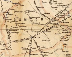
Two years ago, R&R co-founder, J.I. Robinson wrote a short blog about old maps. He shared that maps are a fantastic asset in tracing old house location and family history. He wrote, “over the years we’ve collected old South Carolina maps from all kinds of sources and they offer features not found on current maps. They often include names and locations of personal property and the original tracks for roads and paths. My favorite information derived from these maps, are those showing fords and ferries, with the name of the owners. We’ve also learned that with a degree of sleuthing these maps can be used to locate features thought lost to time.”
Maps are an integral part of our work at Roots and Recall, including the S.C. DOT maps from most counties. These are not ancient maps, but they do include locations of old schools, gins, stores, river crossings, bridges and a great deal of important data. Recently one of R&R’s members commented, “Thank you for posting these maps, as the County Maps represent the start and end of my Paternal Grandfather’s career as County Engineer at the Fairfield County Office of the South Carolina Highway Department.”
The member continued with an entire genealogy of the family associated with his grandfather. Though we have no means to easily track who accesses the maps, it appears they are used routinely by a number of our regular researchers. Here at R&R, we use them to identify tons of old houses, previous house sites, and roads that have been altered. Walking these old road beds is a treasure of sidelights and discovery. There are scores of old maps on R&R, though some counties have far more than others:
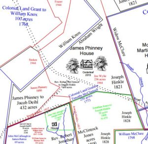
- Plat maps
- SC DOT Road maps
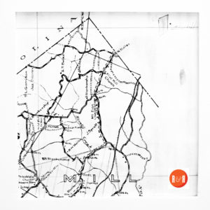
- Mills Atlas maps
- Postal maps
- Soil maps
- School District maps
- Voter registration maps
- Links to geographic maps
All of these are useful in determining old roads, historic meeting and muster grounds, etc. And for those of you who are just beginning to explore your roots, remember routes were continuously altered and moved in the 19th century and certainly in post WWI and WWII era development. Not only were they abandoned in many cases but also straightened, widened and leveled. So, when you are taking a route of discovery remember to layer old maps and watch carefully for changes in landscaping and bridge replacement.
Roots and Recall remains committed to bringing the newest information and updates to the 33,000 sites already found on the website. We focus on building content, not new pages. But as more and more information and images are generated that impact the current pages, less time is available for the cataloging of notes and names on maps. This is very time consuming and takes a very skilled – dedicated eye. Please let R&R know of other useful map websites and maps that are available for digitization. Digitizing them in a useful and usable manner is an important function of the website!
Click on these pages to see some of the maps currently available on R&R:
Late 19th Century Postal Routes and Railroad Maps
Mayhugh’s Plat Maps of Chester County+
Walker’s Postal Maps of York Co SC
One of R&R’s contributors sent a link to:http://www.bfthompson.com/abbeville_colonial_plats/abbeville_colonial_plat_map.htm, in Abbeville District. It is available as a link on the Abbeville County main menu. Has anyone been updating these important maps?

Thank you for caring about history and making R&R a part of your life! WBF
R&R Note: We sincerely hope you and your family had a wonderful Thanksgiving holiday and will continue sharing wonderful memories with family and friends over the rest of 2017. Our pages are full of wonderful stories and ways of sharing family history, tell those around you about just what an impact Roots and Recall has had on you!
