The late-1980’s and early-1990’s was a dramatic time on the world stage. The collapse of a superpower left a void among the former Eastern Bloc countries that was filled with revolution and ideological change. The Soviet Union, having one of the most formidable militaries in the world, slowly disintegrated, racked by government overspending and war debt. As the Iron Curtain collapsed, much of the secrecy went with it. Among the most haunting of these secrets were thousands of detailed maps compiled by The Red Army. The scope of their surveys spanned every corner of the globe. These maps, and what they could have represented, were found in briefcases and soon fell into the hands of private collectors.
In 1987, two years before East and West Germany were reunited, ABC released a 14-½ hour television miniseries titled Amerika. The show, though having mixed reviews, showed what life might look like in the U.S. under Soviet military occupation. Some claimed that the idea was too far-fetched, even for 1980’s television. Other cinematic hits, such as Red Dawn (1984), had already captured America’s “what-if?” imagination and a Cold-War-gone-hot story. Thirty-years later, these incredibly accurate maps are yet another haunting vision of what could have been. The exception is, however, that these maps were not Hollywood fiction, but real and painstakingly created.The author of this article recently acquired several such maps of the Charleston quadrant, drawn to different scales. The first map dates to the late-1960’s, and encompasses Virginia to Georgia (though the map is entitled “Charleston”). The second map, offering an intriguing plan of Charleston just prior to hurricane Hugo, is exacting down to individual structures. The information presented is strategic in nature, and includes railroads, roads (road width is denoted by line thickness), and topography.
Commonality of Natural Disaster and The Cold War
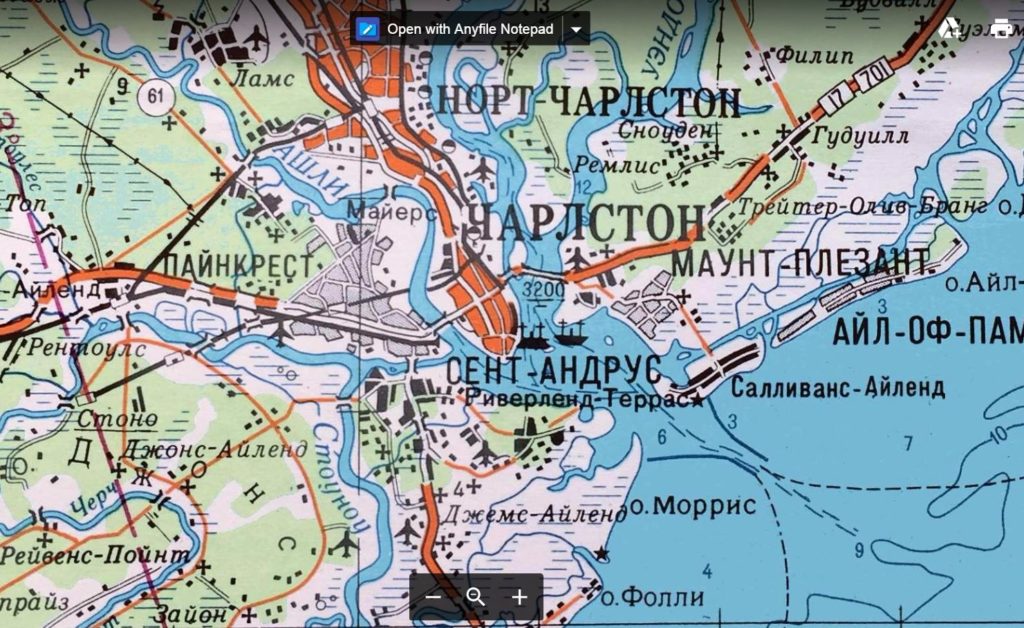
Soviet image of Charleston S.C., ca. 1960s. Courtesy of the author’s collection.
The exponential growth experienced by the Lowcountry in the latter-half of the 20th-century has been well documented in many respects, but understanding its impacts is not. Many scholars studying Charleston history focus on a time period when South Carolina was emerging from British colonialism, and flourishing prior to the American Civil War. In recent years, the focus has begun to shift to sites associated with civil rights and race relations. It makes sense then, that the vast majority of our preservation efforts have been fixated on Charleston’s aging peninsula. This approach, however, may be too narrow-sighted as the Lowcountry expands.
A hotly debated issue, both at the local and the state level, is the completion of I-526. As the battle rages on paper and in community groups, 526 has its roots in the height of the Cold War. Not just I-526, but all interstates, were built following passage of The National Interstate and Defense Highways Act in 1956. President Eisenhower sought to build these
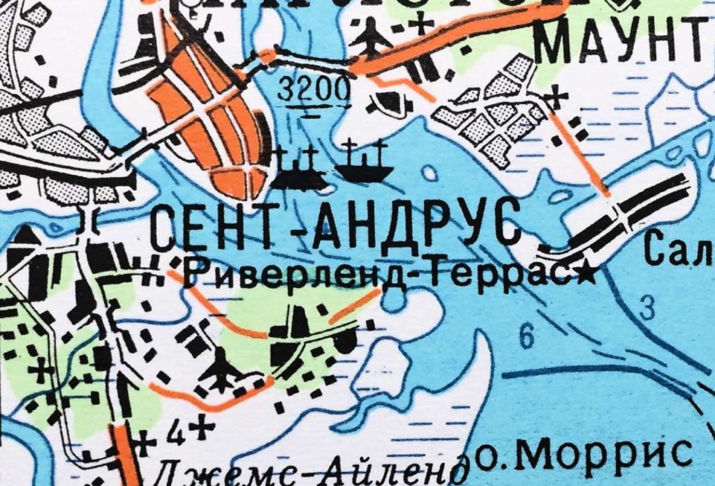
Closeup detail of the Soviet map – Charleston Harbor.
superhighways in a strategic effort, an effort that is reflected in Eastern maps. Proponents of 526 completion claim that the route will be vital to future evacuations and disaster relief, as the islands continue to boom with development. Many preservation-minded groups lament that 526 will simply add fuel to the development fire, and destroy an already fragile historic landscape. Both camps have valid arguments in this case, and will be included among the many resolutions once the project is either scrapped, or passes final inspection. Though the likelihood of Russian tanks rolling down King Street has decreased, the safety and security threats to the tri-county area have evolved.
A New Era: Preservation Risk Management
It is important to note that the city does not exist in a void. Charleston is not an anomaly in time. As cities evolve, there are certain risks that they must respond to. As Soviet officers reviewed the maps, nuclear war was perpetually on the horizon. The Cuban Missile Crisis occurred seven-years before the oldest survey in this article was published. The U.S. Navy’s nuclear submarine presence made the city, and all of its beautiful structures, a prime target. Since these maps were drawn, rampant development could present another prime target for a major flood, massive hurricane, or an unthinkable act of terrorism. Just as these Cyrillic maps present Charleston in a strategic eye, preservationists must look at Charleston strategically; that is, what strategic lessons-learned can be taken from the past 60-years, which can inform preservation efforts? What areas are most at-risk? What major catastrophic risks do we currently face? Tackling this project will produce a comprehensive matrix of risks and a preservation risk management plan that can be continually updated. Indeed, maps are powerful tools to understanding risk, even in an age in which we can explore the world from our phones. Map-able information will be critical to informing architects, developers, engineers, preservationists, and government officials for the future of the Lowcountry.
Zach Liollio was born in Charleston, S.C. in 1993, and grew up across the river in West Ashley. After graduating from The College of Charleston in 2016, he started on a Master’s of Science in Technical Project Management degree at The Citadel. He now works for the S.C. Dept. of Transportation and runs a preservation consulting side-business, Z.P. Liollio & Co. As time permits he enjoys shaping steel as well as academic writing. Zach is a member of the Philip Simmons Guild, S.C.’s guild of artist blacksmiths, and volunteers at the Lexington County Museum where he demonstrated blacksmithing.
You may contact Zach at: liozac0261@gmail.com or (843) 709-8974

Share Your Comments & Feedback: