City Directories and History: Architect, Mr. Robert Mills was hired by the State of S.C. to create accurate maps of the state’s districts. In turn, he employed knowledgeable surveyors to survey the local areas, from which he created his finished maps of S.C., districts or counties. This resulted in accurate maps of roads, streams, and cities located in each. Click on the More Information/ Enlargeable Sections links, (found under the picture column), for an enlargeable county map, a history of Robert Mill’s survey of S.C. counties, written by Gene Waddell in 1980, an index to the names listed on the maps, and enlargeable quadrants for conducting in depth research.
Sloan – Epton’s Spartanburg Co Map ca. 1869. Courtesy of the Cobb Collection – Other Side of the River Museum, 2016
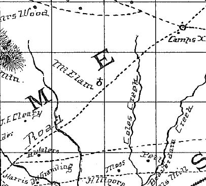
“James Whitten prepared a map of his native “Spartanburgh” and received $800 for it on 7 December, 1818. His manuscript is a careful, clear map, but is somewhat cluttered by a large script.” Information from: Mill’s Atlas of South Carolina – 1825, Southern Historical Press, 1980
R&R has also taken individual county maps and created a list of their recorded sites, allowing R&R’s users, faster access to historic data. Each of the More Information links opens items connected to the Mill’s map of this county. The last four are those related to Quadrants – Sections 1-4. Names within each quadrant are listed below and at the bottom of the page, is an alphabetical list, of all names shown in Spartanburg District, along with other counties in which the name also appears. An excellent resource of this map includes David Rumsey’s Maps.
Scroll down to see the alphabetical listing of names in each section:
| Bishear – Sp | Gist’s Mill – Sp | North Fork Tyger Road – Sp (2) | ||
| Abbet – Sp | Golightley – Sp | Pacolet Mineral Spring – Sp | ||
| Abbet’s Cr. – Sp | Golightley’s Mill – Sp | Pacolet River – Sp (2), U, Y | ||
| Abner – Sp | Good Land – Sp | Paress – Sp | ||
| Abner’s Creek – Sp | Gordon – Sp, Su | Paress Mill – Sp (2) | ||
| Adkin – Sp | Gordon’s Mill – Sp | Patterson, R. – K, Sp | ||
| Adkin’s Mill – Sp | Gosset – Sp- | Patterson’s Spring – Sp | ||
| Anderson’s Bridge – Gr, Sp | Gosset’s Church – Sp | Peeple – Sp | ||
| Anderson’s Mill and Bridge – Sp | Green – Ba, Co, E, Ge (11), Gr, H, Sp, W | Peeples Creek – Sp, U | ||
| Antioch M.H. – Sp | Green’s Creek – Gr, Sp | Peter – Sp | ||
| Battle of the Cowpens – Sp | Greenville – Gr, Lau, P, Sp | Peters Creek – N, Sp, W | ||
| Bellinger – Co (2), Gr, P, Sp | Greenville Post Road – Sp | Ph. M.H. – Sp | ||
| Bellinger’s Road – Sp | Griffin – A, Ch’f, F, Gr, Lan, P, Sp | Pool Land – Sp | ||
| Bennett – Ba, Co, Sp, Su | Griffin’s Tavern – Sp | Poole – Sp | ||
| Bennet’s Tavern – Sp | Hancock – Lex, Sp | Poolsville P.O. – Sp | ||
| Bethel Church – Sp, Y | Hancock’s Mill – Sp | Poor Hilly Land – Sp | ||
| Bethlehem Church – Ch, Sp | Harris Creek – Ch’f, Sp, U | Poor Land – Sp | ||
| Big Shoals – Sp | Head – O, Sp | Poor Level Land – Sp | ||
| Bishear’s Mill – Sp | Head’s Ford – Lau, Sp | Price – Cha, Ch, Co (2), H, Sp | ||
| Black Stock Road – Sp (2) | Hendrix – Sp | Price’s P.O. – Sp | ||
| Boiling Spring Church – Sp | Hendrix Tav. – Sp | Providence Church – Sp | ||
| Broad River – A, Be, Ch, F, Lex, N, R, Sp (2), | Holly Spring Church – Sp | Quin – Sp, Y (2) | ||
| Buck Creek – Ba, H, Sp | Hurricane Shoal – Gr, Sp | Quin’s Ferry Road – Sp | ||
| Buncome Road – Sp | Hurricane Tav. – Sp | Reack – Sp | ||
| Camp’s Bridge – Sp | Iron Ore – Sp (2) | Reack’s Mill – Sp | ||
| Camps P.O. – Sp | Iron Ore here – Sp | Rice Land – Co, Ge, Sp (2) | ||
| Cane Creek – P, Sp, U | Island Ford – E, N, Sp | Roddy – Sp | ||
| Cannon – Ba, D, Sp | Ison’s Creek – Sp | Roddy’s Mill – Sp (2) | ||
| Cannon’s Mill – D, Sp | Ison’s Mill – Sp | Roger – A, Co, E, H, Sp | ||
| Cantrell – Sp | Jackson’s Mill – Ch’f, O, Sp | Roger’s Bridge – Sp | ||
| Cantrell’s Mill – Sp | James’ Creek – Sp | Rowland – Co (2), Sp | ||
| Cedar Spring Church – Sp | Kindrip – Sp | Rowland’s Mill – Sp | ||
| Chapel Church – Sp | Kindrip Tav. – Sp | Rush – Sp | ||
| Chapman – Ch’f (2), Sp | Laurenes – Gr, N, Sp, U | Rush Mill – Sp | ||
| Chapman’s Saw Mill – Sp | Lawson – Cha, Sp | Rush Tav. – Sp | ||
| Cherokee Creek – P, Sp, U | Lawson’s Fork – Sp (2) | Rutherfordton Post Road – Sp | ||
| Cilkey’s Creek – Sp | Legan – Sp | Rutherfordton Road – Sp | ||
| Clark’s B. Forge – Sp | Legan’s Mill – Sp | Sandy Ford – Lau, Sp | ||
| Coleman’s Tav. – Sp (2) | Lewis, Dr. – Sp | Sarratt – Sp | ||
| Collin – Sp | Lewis’ Mill – Sp (2) | Sarratt’s Creek – Sp | ||
| Collins Mill – Sp | Limestone Quarry – Sp | Shoal Island – Sp, Y | ||
| Comer of Union and York – Sp | Linder – Co, Sp | Smith Mill – D, Gr, Sp (2) | ||
| Conch – Sp | Linders Tav. – Sp | Smith P.O. – Sp | ||
| Conch’s Mill – Sp | Line of Greenville and Laurens – Sp | Smith Tav. – Cha, O, Sp | ||
| Cooper – Ba, Cha (2), Lau, O, Sp | Logan’s Road – Sp | Soap Stone Quarry – Sp | ||
| Cooper Mill – Lau, O, Sp | Maken’s, Mr.: Tav. – Sp | South Fork of Pacolet River – Sp | ||
| Cothe – Sp | Maple Swamp Creek – Sp | South Fork Tyger River – Sp (2) | ||
| Cothe’s Ford – Sp | ||||
| Cotton Factory – Sp (2) | Marble – Sp | Spartanburgh – Gr, Lau, Sp, U, Y | ||
| Creek Bridge – Sp | Martin – A, Be (2), Co, E, Ge, P, Sp | Sugar Creek – Sp, U, Y | ||
| Cross Anchor’s P.O. – Sp | Martin’s Mill – A, Sp | Tanner – N, Sp | ||
| Crow – Sp | McDaniel – P, R, Sp, Su (3) | Tanner’s Mill – Sp | ||
| Crow’s P.O. – Sp | McDaniel’s Mill – Sp | Thickety Mountain – Sp | ||
| Dare – Sp, Y | McDanielsville P.O. – Sp | Thickety Creek – Sp, U | ||
| Dare’s Ferry – Sp, Y | McKee – Be (2), Sp | Thompson’s Tav. – Ch’f, Sp | ||
| Dare’s Mill – Sp | McKee’s Mill – Sp (2) | To Spartanburgh – Sp | ||
| Dutchman’s Creek – F, Sp, U, Y | McKee’s Mill and Ferry – Sp | To the North Carolina line – Sp | ||
| Easterwoods Shoal – Sp | McKee’s Tavern – Sp | Tolleson – Sp | ||
| Enoree River – Gr, Lau, N (2), Sp (2), U | McMaken – Sp | Tolleson’s Road to the Line – Sp | ||
| Extreme Poor and Level Land – Sp | McMullen – F, Sp | Tolleson’s Tav. – Sp | ||
| Fair Forest Creek – Sp, U (2) | McMullen’s Mill – Sp | Troft – Sp | ||
| Falls 16 feet to 40 ch. – Sp | Meadow – Sp | Troft Shoals – Sp | ||
| Falls 8 feet in 4 ch. – Ch (2), Sp | Meadows Creek – Sp | Tugaloo Road – P, Sp | ||
| Falls in 3 ch. 10 feet – Sp | Mean – Sp | Tuggle – Sp | ||
| Falls to 10 ch. 12 feet – Sp | Mean’s Mill – Sp | Tyger River – F, N, Sp, U | ||
| Femandeis – Sp | Melville – Sp | Union – Ch, F, Lau, N, Sp, Y | ||
| Ferguson – Cha, Co (2), Sp, W | Middle Fork Tyger River – Sp (2) | Upper end of Boat Navigation – Sp | ||
| Ferguson’s Creek – Sp | Miller’s Br. – Sp | Upper end of Canoe navigation – Sp | ||
| Fernander’s Mill – Sp | Miller’s Creek – Sp | Varner – Sp | ||
| Flint Hill – Sp | Miller’s Mill – O, Sp | Varner’s Mill – Sp | ||
| Ford’s, Widow: Br. – Gr, Sp | Moore – Co (3), Lau, Sp | Varner’s Tavern – Sp | ||
| Foster – Cha, Lau, N, Sp | Moore’s Tav. – Sp | Wofford’s Mill – Sp | ||
| Foster’s Church – Sp | Motlow – Sp | West – Lau, Sp (2), Su | ||
| Foster’s Tavern – Sp | Motlow’s Creek – Sp | West Mills – Lau, Sp | ||
| Fradonia – Sp | Mount Elam – Sp (2) | Wheeler – Cha, Sp | ||
| Friendship Church – Sp | Mount Pleasant Tav. – Sp | Wheeler’s Mill – Sp | ||
| From Fork Road to Union Line – Sp | Mount Vernon Tav. – Sp | White Oak Rich Bottom Land – Sp | ||
| From Greenville Line to Head’s Ford – Sp | Muckelwrath – Sp | Wofford – Sp | ||
| From Greenville Line to Union Line – Sp | Muckelwrath’s Mill – Sp | Wolf – Mar, P, Sp | ||
| From the Fork to Union Line – Sp | Navigable for Small Boats – Lan, Sp | Woodruff – Sp | ||
| Furnace P.O. – Sp | Nazareth Church – Sp | Woodruff’s Tav. – Sp | ||
| Gainey – Sp | Nesbit – E, Ge (3), Sp, Y | Wyatt – Sp | ||
| Gap Creek Road – Sp | Nesbit’s Forge and Mill – Sp | Wyatt’s Mill – Sp | ||
| Gault – Sp, U | Nesbit’s Furnace – Sp | York – Lan, Sp, U | ||
| Gault’s Tav. – Sp | Nesbit’s Mill – Sp | |||
| Ge (2), K (8), Lan (10), Lex, R (2), Sp, | New Hope Church – Sp | |||
| Gilkey – Sp | New Hope P.O. – Sp | |||
| Nickel – Sp | ||||
| Nickel’s Mill – Sp | ||||
The Yorkville Enquirer of May 11, 1892 reported on the death of Mr. John B. Mintz. In 1840 as a young-man he went to the Hurricane Shoals ironwork in Spartanburg Co., as a laborer where he learned the business. He was later employed by the Cherokee Ford Ironworks as one of the bosses. He spent sometime as a farmer but in 1867, with the late J.A. Deal as partner, attempted to revive the manufacture of iron at the old Kings Mountain Ironwork’s on the Broad River where the Cherokee Falls Cotton Mills is now located. That work was soon abandoned.”
Stay Connected
Explore history, houses, and stories across S.C. Your membership provides you with updates on regional topics, information on historic research, preservation, and monthly feature articles. But remember R&R wants to hear from you and assist in preserving your own family genealogy and memorabilia.
Visit the Southern Queries – Forum to receive assistance in answering questions, discuss genealogy, and enjoy exploring preservation topics with other members. Also listed are several history and genealogical researchers for hire.
User comments welcome — post at the bottom of this page.
Please enjoy this structure and all those listed in Roots and Recall. But remember each is private property. So view them from a distance or from a public area such as the sidewalk or public road.
Do you have information to share and preserve? Family, school, church, or other older photos and stories are welcome. Send them digitally through the “Share Your Story” link, so they too might be posted on Roots and Recall.
Thanks!

