City Directories and History: The area at the western edge of Bennettsville has long been known as Ayers, a contraction of Ayer Station. It was so-called in honor of the Ayer family, two of whose homes were nearby. Thomas Ayer, a native of Ireland, came to Marlboro from Virginia in 1758. His son Lewis Malone Ayer lived here before moving to Barnwell. Another son Hartwell lived nearby on a large tract of land upon which West Bennettsville is now located.
Beattie Hill rises above the River Road near old Sawmill Baptist Church. Reverend William Q. Beattie (1798-1884) came to South Carolina from a northern state. He married Ann Eliza Terrel (1811-1883), daughter of John Terrel, and their home was on this hill. Mr. Beattie served many Baptist churches on both sides of the river.
Beverly Creek, earlier called Beverly’s Mill Creek, in the upper section of the county, was probably named for Benjamin Beverly who came there from Virginia prior to the Revolution. He died in 1807.
Bristow, a community between Blenheim and Brownsville, was named for Captain Alexander Emanuel Bristow, Co. D., 26th Regiment, C. S. A.
Brownsville, an area in the southern part of Marlboro County, received its name from the Reverend John Brown and his sons. a large landholder in the area. John Brown came to the Cashua Ferry Baptist Church in 1759 as its second pastor. When that church divided, the segment of the congregation east of the Pee Dee River moved near Brown’s Mill at Cleveland Hill. It was, for a short time, called Muddy Creek Baptist Church because of the stream nearby. Upon a subsequent move of about two miles, the church became Brownsville Baptist Church and the name was applied to a broad area.
Bruton’s Fork, a community north of Bennettsville, probably derived its name from Wiliby Broughton. He was a pioneer of that section of Marlboro County, who owned practically all the land bounded by the forks of Beaver Dam and Crooked Creek.
Burnt Factory is the name long used for the site of the first cotton mill built in Marlboro County. It was organized in 1834 by Colonel John Nicholas Williams of Society Hill, John McQueen, afterwards a member of Congress, and William T. Ellerbe of Marlboro County. The mill was destroyed by fire in December 1851 and was never rebuilt. Tradition tells us that he, feeling cramped by the approach of population and civilization, decided to move on further west and sold all his land to James Stubbs for a horse, saddle, bridle, and rifle. It was James Stubbs who, in 1837, donated the piece of land upon which Bruton’s Fork Baptist Church now stands.
Cashua Neck and Ferry in the early days was an important crossing of the Pee Dee River, leading travelers into Darlington and Marion Counties. It is sometimes spelled “Cashway” or “Cashaway,” but Cashua was used earliest. Bishop Gregg wrote that one of the first owners named it “Cash-way,” meaning that all persons who crossed were to pay cash. Other historians believe that the name derived from a corruption of cause way or “caseway” as is written on old deeds.
Clio was named for the muse of history. It had formerly been called Ivey’s Crossroads and Hawleyville for early merchants. William Rogers, a man from the North as Hawley was, followed him in business at the crossroad site and it is said to have been he who named the village Clio. Mr. Rogers was the maternal grandfather of Governor Thomas G. McLeod. There is little doubt that from the earliest period there has been a river crossing at this point. Nearby was one of the earliest Baptist congregations, later dissolved into churches on both sides of die Pee Dee River.
The “Carolina Section” which lies between Clio and the North Carolina line is centered around the old Presbyterian church founded by the Scots who flowed back and forth between the two Carolinas in the early 19th century.
Cottingham Creek was named for the owner of the property it crossed, east of Bennettsville. Charles Cottingham came to the county probably just prior to the Revolution. He received a grant in 1791.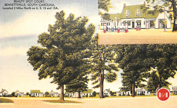
Coward’s Mill on White’s Creek was the property of James Coward, who died in 1845, leaving a considerable estate. and died there in 1817. He was probably descended from the earlier James, who owned land there in 1756.
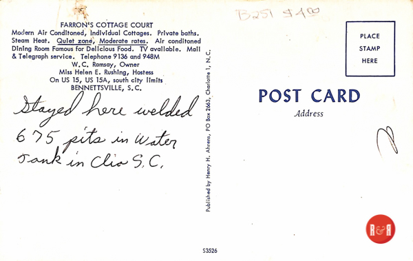
Tourist courts once lined the small town streets of Lowcountry S.C. as travelers flocked the Florida. Courtesy of the AFLLC Collection – 2017
Drake, on Three Creeks in the southeastern section of the county, has been the center for the descendants of Zachariah Alford Drake, who came from North Carolina to Marion and on to Marlboro County in 1847. For many years Drake was a station on the railroad and a post office.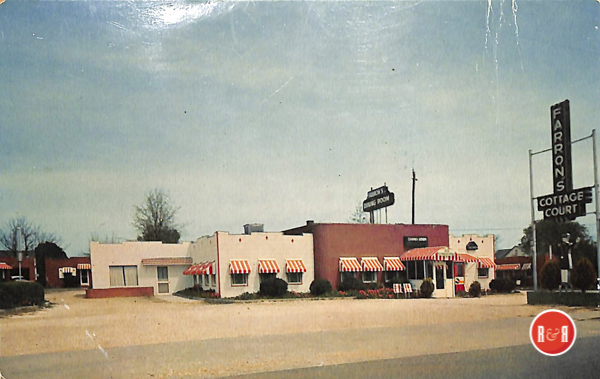
Dunbar, a farming community, was named for Daniel Dunbar who lived in the area after the Revolutionary War.Dyer’s Hill was long the name of a schoolhouse and a voting precinct near the original site of the old courthouse. It is named for John A. Dyer, “schoolmaster,” and member for the Parish of St. David’s of the 1768 Assembly.
Egypt’s Mill is still a well-known place though the name is normally shortened to “Egypt.” It was for many years a thriving mill on lower Crooked Creek where quantities of com were ground and traded. There was said to be “plenty of com” at Egypt. It was the first grist mill in Marlboro County and said to have been built by General Tristram Thomas (1752-1817) soon after the Revolutionary War. He was, during that period, the county’s outstanding leader.
Famine Falls has long been known and called by this name. It is in the Pee Dee River about five miles south of Hunt’s Bluff, where there are many sand bars. A large one at this point, visible when the river is low, forms a flowing ripple or small falls. When the falls are apparent there are no fish caught, hence the name “famine.”
Gardner’s Bluff marks the site of an early ferry on the Pee Dee River, near the original Marlborough Court House. The derivation of the name is obscure. Possibly it came from William Gardner, who received a grant of 100 acres near the bluff November 4, 1762. It could have been named for Stephen Gardner. He purchased from Thomas Powe a large tract of land there in 1790.84 In that year Gardner was residing in Guilford County, North Carolina. The bluff was for a long time an important port on the river. Until 1884 all Marlboro freight was transported to Gardners Bluff, where it was hauled by wagon teams six miles to Bennettsville over roads which were impassable in rainy weather.
Goodwin’s Mill on Crooked Creek marks the center of large business operations and the home of Ebenezer W. Goodwin, Representative to the Secession Convention. After 1822, for a time the stage coach from New York to New Orleans passed this site. Mr. Goodwin was the grandson of Charles Bright for whom Brightsville was named. The Goodwin home was destroyed by fire, February 1969.
Goose Mash is the name of a section near the Society Hill bridge along the Pee Dee river familiar to the residents of the area. There is speculation about the origin of the name. Was it Goose Marsh, which the soft accent corrupted to “Mash”? Or was it originally “Goose Mast,” since “mast” means food on the forest floor? At any rate, its name began when wild geese were plentiful in the river swamps.
Gum Swamp is the area of the Little Pee Dee River, near the North Carolina line as it flows southeast toward Dillon County.
Hagan’s Prong, also spelled “Hagin’s,” is one of the branches which forms Three Creeks, flowing between Clio and Blenheim. It is believed to have been named for Isham Hagin, a large landowner in that area. The first mention of him in county records is for receiving a grant of 775 acres of land from Governor Thomas Pinckney May 7, 1787.
Hardwick’s Branch, in the northwestern comer of the county, was named for William Hardwick. He was one of the men commissioned to build St. David’s Church in Cheraw, on which he reported in 1774.
The Hebron section of the county was named by Nathan Thomas (1762-1842), who lived there following his service in the Revolutionary War “in memory of the fair inheritance given the Biblical patriarch Caleb in reward for his fidelity and valor.” He died in upper Marlboro in 1788.
Henagan Lake earlier was called Mandeville Lake as it lay in the vast acreage of Cornelius Mandeville. In 1858 Angus B. Henagan purchased the lake and surrounding land from J. H. Lane.41 42 He sold it in 1863 to John McQueen.
Herendine Prong is a branch of Naked Creek. It is so spelled on many old deeds and on at least one map. Since that time the “big lake” has been Henagan Lake. On more recent maps it is designated incorrectly as Herndon Branch. On November 8, 1793, Thomas Herringdine deeded 100 acres to Edward Crosland (1740-1821). On May 7, 1767, Silas Herendine, who was the father of this Thomas, had received a grant of 250 acres on Crooked Creek. This land now comprises most of East Bennettsville. The name was originally Harrington. General usage misspelled it. The common and usual pronunciation and spelling in the community was Herendine.
Hicks Creek, crossing the northwest comer of the county, commemorates an early family, now extinct. It is probable, though not certain, that the creek was named for John Hicks, who owned land there prior to 1740.48 49 Colonel George Hicks, one of the county’s leading citizens during the Revolution and afterwards, resided on land near Gardner’s Bluff, still referred to as “Hicks’ Field.”
Horse Pen Creek, just north of Blenheim, received its name from a pen at the fork, used in the early days of the county for the purpose of entrapping wild horses. This was a common custom.Hunt’s Bluff is thought to have been first called Westfield Bluff for an early owner. On November 29, 1750, John Westfield received a grant of land which included the bluff. In 1768 he served as a member of the Assembly from the Parish of St. David. He married a daughter of James Gillespie, Sr. Later with his wife he returned to Virginia and died there. The bluff passed to Robert Hunt and was sold after his death to Joseph Alston.
Husbands’ Creek, running into the Pee Dee River, just above Highway No. 1, bears the name of John Husbands, who lived in that area prior to the Revolution. He received a grant of land April 6, 1786. It was already called Hunt’s Bluff when, in 1780, it was the site of Marlboro County’s only military skirmish during the Revolution when one hundred British soldiers were captured.
Indigo Lake and Indigo Field are both still well-known to those familiar with the river area of Marlboro County. They were named in the early days when indigo was a profitable crop in the rich, alluvial land.
Kolb Ferry was the name formerly used for the crossing of the Pee Dee River, north of the bridge to Society Hill. Earlier it was known as James’ Ferry. Colonel Abel Kolb who lived and was slain by Tories near this site, was the son of Peter and Ann James Kolb. Ann was the eldest daughter of Reverend Philip James and granddaughter of James James, leader of the Welsh Colony. Philip James was the first pastor of the Welsh Neck Church. Abel Kolb married Sarah James and through her inheritance became possessed of the plantation where they lived and of the ferry. Later the ferry came to be known as Sparks’ Ferry.
Kollock was a railroad station just across the Pee Dee River from Cheraw. It was built on the plantation of Oliver Hawes Kollock (1790-1862), who came to Marlboro County prior to 1820 from Massachusetts. In 1950 the name of the post office was changed to Wallace. apparently the property of Samuel Sparks. The village, now Society Hill, was sometimes referred to as Sparks’ Ferry.
No one now knows the exact location of the post office which existed in 1819, called Laurinton. Undoubtedly it was named for the McLaurin family, who settled in the neighborhood of Red Bluff, north of Clio, about 1790.
In 1890 when the Atlantic Coast Line stations were built north of Bennettsville, one was called Alice for the daughter of J. Frank Breeden, whose land it occupied. The name was changed to Lester when the post office was built to honor William Lester, who came from Maryland to the northern part of the county just prior to the Revolution.
Licldog was the site of an early school. For more than a quarter of a century it was a voting precinct. Its name arose from the flattened log, holding loose salt, which was used as a lure for cattle when the Fence Law was implemented. It is located about a mile west of Grant’s Mill in the Sandhills section of the county.
Lightwood Knot Creek in the northwest comer of the county runs between the “upper” Goodwin’s Mill and Quick’s Mill, both long inoperable. It evidently received its name from a piece of fat pine wood being used as a surveyor’s stake or perhaps merely from a pine stump in the creek. In 1860 there was a post office there: Lightwood Knot, South Carolina.
Lilly Quick Creek crosses a part of northern Marlboro County and enters Crooked Creek between Burnt Factory and Lake Wallace. It was named in honor of Lillie Herndon Quick (Mrs. Fred M. Quick) (1876-1947). The Little Lakes are sometimes spoken of as “The Three Lakes.” They are little as compared to Rogers Lake nearby and there are three of them, all very deep and clear.
Machine Branch runs into Muddy Creek. It probably received its name from the cotton gin which was owned and operated by James Ezra Coxe and perhaps by his father before him. Their gin, store, and home were at Coxe’s Cross Roads, near where J. E. Coxe’s great-grandfather, Emanuel Coxe, settled when he came to the country long before the Revolution.
McFarlan Section, just north of the city limits of Bennettsville, still goes by this name but the origin is somewhat obscure. Presumably it came from the early ownership. In 1827 John McFarlan of Georgetown left property in this section to his wife, Rebecca, of Marlborough District. In 1836 she, in turn, left it to her nephew, William Cooper.
Mother Griffin Island lies in the Pee Dee River about four miles upstream from Gardner s Bluff. It still bears the name given it when Elizabeth Griffin, a widow with two young sons, Michael and William, received a land grant for it January 22, 1745.
Naked Creek rises in the Sandhills section of Marlboro County and enters the Pee Dee River at Gardners Bluff. Old maps show it as the site of many grist mills and it has been described as a “bold and fertile stream.”
Newtonville, near the North Carolina border, is named for Giles Newton, many of whose descendants live in that area. He emigrated from England to Henrico County, Virginia, before the Revolution and to Marlboro County just following it. He died in Newtonville in 1807.67 Presumably its name derived from the naked trees which, in winter, lined its path.
The Old River in the area of Screven Neck, along the southern edge of Marlboro County, is a long narrow lake. It is called “The Old River” because it is a part of the path which the Pee Dee River followed long ago.
Parker’s Ferry crossed the Pee Dee River at the North Carolina line. It was on the property granted Elisha Parker, where he died about 1800. His son Stephen built boats for river traffic before the Revolution. Stephen died about 1810.
Parnassus, a Methodist Church built in 1835, was named for the mountain in classical Greek literature. Though the Marlboro site is flat and sandy, the sur-rounding area has adopted the name. The Charleston Courier, May 2,1835, said “the name of the post office heretofore called ‘Little Mechanicsville’ in South Carolina, has been changed to Parnassus.”
Phill’s Creek is sometimes spelled “Phil’s” but rarely. In the western part of the county, it probably was named for Philemon Thomas (1786-1792), a large landowner in the early days.70 His nickname seems to have been spelled “Phill.” He was born in Maryland, emigrated to the Welsh Tract and was one of the founders of the St. David’s Society in 1778.
Pigeon Ridge is a bluff above the Pee Dee River a few miles south of the Society Hill road. It was named by early residents of the area for the great flocks of pigeons which “darkened the sky.”
Pine Grove, called Piney Grove in earlier times, has been a place of worship for nearly two centuries. Quakers used it first. When they left Marlboro County, their meeting-house was used by Baptist and Methodist congregations for a while.
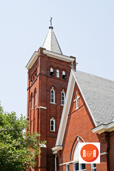
Pledgers Mill was an early mill on Crooked Creek. It was often called Pledger’s Old Saw Mill. It gave its name to Saw Mill Baptist Church, which is still active, having passed to an African American congregation after the court house was moved to Bennettsville. Pine Grove is now the site of a United Methodist Church. Its name is self-evident; its influence far-reaching.
Philip Pledger came to Marlboro County about 1752 and settled where he afterwards built his saw mill. He and at least three of his sons rendered distinguished service during the Revolutionary War.
Pouncey’s Landing, still marked on maps of the Pee Dee River, indicates the shipping point for the neigh-borhood of the land holdings of the Pouncey family, now extinct in Marlboro County. Major James Pouncey came there as a youth and married a daughter of Abel Kolb, the brave patriot who was killed by Tories, April 28, 1781.
Poverty Ridge and Poverty Creek are part of the wooded area west of Three Creeks, along the Pee Dee River. Their names describe the poor soil found there.
There are two Quick’s Cross Roads named for the numerous members of that family who first came to Marlboro County from Bertie County, North Carolina, after 1742. The Quick’s Cross Roads which serves as a voting precinct is at the intersection of South Carolina Highways 55 and 54.
The other one is near Aaron’s Temple, an African American church near the Wire Road. Both are in the Sandhills section of the county.
There are two places called Red Bluff in Marlboro County. On the Great Pee Dee River, the day bluff is about four miles south of the Cashua Ferry bridge. The Red Bluff on the Little Pee Dee River is six miles northeast of Clio. It was this area which attracted some of the Scots who came to the Cape Fear Colony in North Carolina and further south. This was the site of an early cotton mill. Red Hill designates an area of Marlboro County around Machine Branch and Salem. The name undoubtedly came from the long clay bank near Hunt’s Bluff. From 1896 to 1903 there was a post office at Red Hill.
Red House Branch is the swamp area near the Pee Dee River north of the Cashua Ferry Bridge. It was given its name because of an old building nearby which long ago had been painted with brick-dust paint. During Carpetbagger and Red Shirt days it became a gathering place for political discussion which on at least one occasion ended in a fracas.
The River Road crosses Marlboro County, following the same general course as the Pee Dee River. Beginning as an Indian trail, it became the stage coach road from Marion, South Carolina, to Rockingham, North Carolina. Since 1747 it has been called the River Road.
Rogers Mill Creek is now called Rogers Creek. It received its name from the mill operated there by Clarence B. Rogers (1848-1905). He purchased the land on the creek in 1873.
Salem is the site of a still-active Baptist church, organized in 1793, which has given its name to a widespread community. It was originally Three Creeks Church, but the name was changed to Salem in 1822 at the instigation of Reverend Robert Thomas (1733-1817) who served as its pastor from its beginning and for a period of nearly twenty-five years.
Salem, the early name for Jerusalem, means Peace. Perhaps Robert Thomas felt the name was appropriate since it was in Jerusalem that St. David was consecrated Bishop of Wales.
Screven Neck probably perpetuates the name of Elisha Screven, the grandson of the Reverend William Screven, the first Baptist minister ever to come to South Carolina.
Alran Neck in honor of John Alran, who lived there and served as an early Justice of the Peace. Records show that in 1795 the neck was owned by Elisha Screven, and he was probably the son of Elisha, who in 1757 devised to his sons Elisha, Immanuel, and William “1,000 acres of land bounding on Pee Dee bought of Othniel Beale.” The father, Elisha, is presumably the one who laid out the town of Georgetown. The Neck was formerly called Alran Neck in honor of John Alran.
Screwpin – For many years until very recently, a giant screwpin (cotton screw press) from an ancient cotton press stood embedded upright to mark a ninety-degree turn in the River Road, giving the turn the name Screwpin. No one now seems to remember who placed it there. In the years between the two World Wars it was the gathering place for the early morning deer drives and fox hunts. “Meet us at the Screwpin” was the rallying cry for sportsmen of that time.
Sugar Loaf is a deep bend in the Pee Dee River, almost forming an island, about six miles upstream from Cashua Ferry. Presumably the shape of the bend reminded early river travelers of their cone-shaped sugar loaves.
Tator House Road branches from East Main Street at the northern edge of Bennettsville. It formerly led to a packing house on the railroad where potatoes were graded and loaded for shipment. Since the road led to a dead end there, it has always been Tator House Road. It is now residential. Tatum, a settlement since 1869, was first called Mt. Washington, then Hamer in honor of the family whose land it occupied. It received its permanent name from Richard J. Tatum (1832-1918). He came to Marlboro County from Guilford County, North Carolina, in 1867.
Terrers Landing was an important late 18th and 19th century shipping point on the Pee Dee River where Captain John Terrel and his family lived. He received a grant of land there December 21, 1789. He was a grandson of William Terrel, one of the original Welsh settlers.
Three Creeks, called Three Runs by Robert Mills, and described as the third most important creek in the county, runs across the southeastern comer into the Pee Dee River. It would seem that its name comes from the three creeks which compose it: Carter Branch, Cottingham Creek and Hagan’s Prong.
After the J. P. Stevens Company built a large mill at Kollock, a larger post office was necessary. The name was changed to Wallace in honor of Senator Paul A. Wallace (1901-1958), who represented Marlboro County in the State Senate from 1946 to 1958. Residents of the area, however, believe its name comes from its appearance. The creek actually runs in three channels for much of its path.
White’s Creek has given its name to the whole northern strip of Marlboro County where it originates. It probably gets its name from James White, an early landowner in the county. In 1792 he deeded a large tract in upper Marlboro to William Shanks.
The Wire Road is sometimes called the Telegraph Road, but the former name has persisted. It was the first road in the county to carry telegraph wires. It is now South Carolina Highway 165.
Wolftrap is still known as part of a 1765 grant to Emanuel Coxe.
Yankee Dam is a place known only to nearby residents. It lies between Bristow and the Pee Dee River. A dam was thrown up by a “Yankee” timber man whose name is now lost. He came from the north to purchase timber and stored it in a small lake made by damming a creek. His descendant, F. E. Coxe, farms it now. In the days when wolves were a menace to cattle, a large “dead-pole” trap gave the plantation its name. In other scattered sections of Marlboro County are Wolf Creek, Bear Creek, Panther Creek, and three separate Beaver Dam Creeks. —Eleanor T. McColl
(Information from: Names in South Carolina by C.H. Neuffer, Published by the S.C. Dept. of English, USC)
Stay Connected
Explore history, houses, and stories across S.C. Your membership provides you with updates on regional topics, information on historic research, preservation, and monthly feature articles. But remember R&R wants to hear from you and assist in preserving your own family genealogy and memorabilia.
Visit the Southern Queries – Forum to receive assistance in answering questions, discuss genealogy, and enjoy exploring preservation topics with other members. Also listed are several history and genealogical researchers for hire.
User comments welcome — post at the bottom of this page.
Please enjoy this structure and all those listed in Roots and Recall. But remember each is private property. So view them from a distance or from a public area such as the sidewalk or public road.
Do you have information to share and preserve? Family, school, church, or other older photos and stories are welcome. Send them digitally through the “Share Your Story” link, so they too might be posted on Roots and Recall.
Thanks!