National Register Property
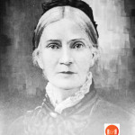
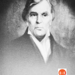
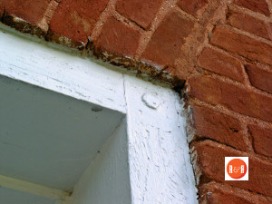
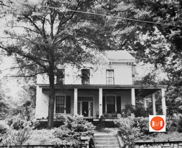
City Directories and History: (Vardry McBee House; Alexander McBee House) Brushy Creek was originally an excellent example of a nineteenth century upcountry South Carolina farmhouse (Carolina I-House style), with twentieth century alterations and is associated with Vardry McBee (1775-1864), prominent nineteenth century businessman, entrepreneur, and delegate to the Secession Convention of Greenville District known as the “Father of Greenville,” and his son Alexander McBee (1822-1897), prominent nineteenth-century businessman, banker, and state representative of Greenville District. The house was built ca. 1836 as a one-and-one half story frame farmhouse consisting of four downstairs rooms, a wide central hall, two upstairs rooms, four exterior chimneys, and a wooden shingle room. The original kitchen, a separate frame building, stood behind the house.
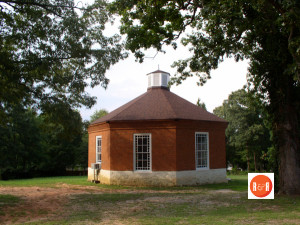
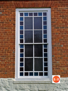
In 1924 the house was expanded with the addition of a one-story frame room between the southwest elevation of the original house and the northeast elevation of the kitchen, incorporating the kitchen into the house itself. Further renovations were made in 1938-39 and 1951. The property also includes three contributing outbuildings: a log barn, a brick shed, and a well house, in addition to the ruins of a grist mill. The yard is landscaped with large English and American boxwoods planted in the 1930s and with brick walls and walks, constructed of bricks salvaged from the Camperdown Cotton Mill in Greenville. Listed in the National Register October 6, 1999.
View the complete text of the nomination form for this National Register property.(Courtesy of South Carolina Department of Archives and History)
In the year 1815 one of the most important deeds in Greenville history was made, the conveyance by Lemuel J. Alston to Vardry McBee of Lincolnton, North Carolina, conveying to him 11,028 acres. Thus the predominant ownership of the Greenville area passed into the hands of a man who for more than half a century was to play a leading and generous role in developing Greenville industrially, commercially and importantly encouraging its schools and churches.
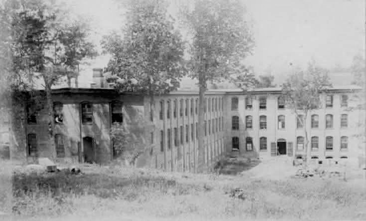
Conestee Mill of Greenville, S.C. – 2025
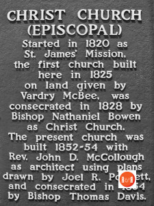
By 1824 much progress had been made in the County and in the village. The new academies had been built just north of the village on land donated by McBee and these first schools of Greenville were built by public subscription. Visitors from the lower part of the State, among them ex-Governor Middleton and Governor Alston, had been instrumental in establishing the first church in Greenville, the Episcopal Mission, which was Greenville’s first religious build-ing. However, many other churches had sprung up in other parts of the county, notably the Presbyterian Church at Fairview in the year 1786 and others such as Brushy Creek, Enoree and Reedy River. Probably one of the most interesting maps of Greenville County and probably the first comprehensive map is that which was surveyed by Stribling in the year 1820 and which Robert Mills reprinted in his Atlas in 1824. Robert Mills showed a great deal of interest in Greenville and made his home here briefly while he was Commissioner of Public Works for the State of South Carolina. On this 1824 map are a number of names of mills and settlements. On the map mountains are listed by name and we find one just west of Caesars Head called Mount Misery. The Dismal is located on this map, being the territory just south of Caesars Head, also Green Mountain, Brad-ford Mountain, Peters Mountain, Panther Mountain, Corbin Mountain, Glassey Mountain, and Paris Mountain which was in Richard Pearis’ original tract and which still bears his name, although it has been spelled for many years Paris. As to the rivers and creeks, there are many with Indian names, the Saludas, south, middle and north, joining to form the Saluda River, the three branches of the Tiger River, Beaverdam Creek, Enoree, also an Indian name and then Brushy Creek and Reedy River taking their names probably from the luxuriant growth of canes along their banks, Laurel Creek, and Golden Grove Creek in the lower part of the County. One creek in upper Greenville County feeding into the middle Saluda is called Oil Camp Creek which puzzles as to its derivation, also Mush Creek further east. The early settlements shown on this map in 1824 were Earles in upper Greenville County, Otis Post Office, which is the present Travelers Rest, Lesters, McBees Mills on the Reedy, Carruth’s Armory near the present site of Conestee, Gowans on the site of the present Gowansville, Golden Grove which still exists as a thriving rural community, Fairview built around the Presbyterian settlement at that place, and then Greens Tavern and Youngs and Lesters. Some of these sites are traceable to present towns within the County. In those days the Ridge Road, or the White Horse Road, ran from east of Newby’s place on the Ashe-ville Road west of the village of Greenville and came into the Augusta Road down below the present Greenville. This White Horse Road runs for almost forty miles without crossing a stream. It takes its name from the White Horse Tavern which was located at the upper intersection of this road with the old Asheville Road. Other roads shown are: Saluda Gap Road, Pendleton Road and the Road to Laurensville Court House. In early Greenville history Joel Poinsett, who was later to become a famous American and for whom the poinsettia was named, was a resident of Greenville. He established a summer home in the mountains right below Saluda Gap and he had also an extensive home on what is now Pendleton Road, property later belonging to R. A. Means.
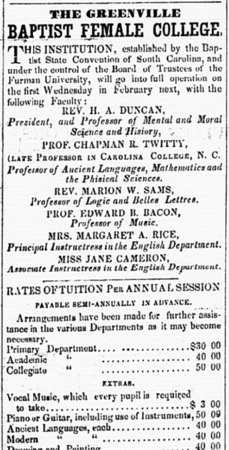
Advertisement from the Edgefield Advertiser of 1856
The original house burned many years ago. The village grew slowly with a population of 500 in 1824. However, at that time the total county population had gone to some 14,000 people, most of whom lived outside of the village. Farming was the principal industry, but there were a number of small manufacturing plants which grew up along the falls and shoals of the Enoree and the Reedy and other rapidly flowing streams of the county and many early manufacturing plants were located in Greenville. The mills of McBee, built at what is now Conestee, consisted of a paper mill, a woolen mill and a cotton mill called Reedy River Manufacturing Company. These mills were ably built by John Adams, a mill-wright and engineer, whom he brought into Greenville and whose descendants still live here. In the year 1851 Furman University was established in Greenville under the leadership of Dr. James C. Furman and by 1858 the Baptists had also negotiated for the purchase of the Greenville Female Academy and had established there a Baptist College for women.
(Information from: Names in South Carolina by C.H. Neuffer, Published by the S.C. Dept. of English, USC)
Stay Connected
Explore history, houses, and stories across S.C. Your membership provides you with updates on regional topics, information on historic research, preservation, and monthly feature articles. But remember R&R wants to hear from you and assist in preserving your own family genealogy and memorabilia.
Visit the Southern Queries – Forum to receive assistance in answering questions, discuss genealogy, and enjoy exploring preservation topics with other members. Also listed are several history and genealogical researchers for hire.
User comments welcome — post at the bottom of this page.

R&R HISTORY LINK: TEXT – NR NOMINATION

R&R HISTORY LINK: NATIONAL REGISTER – IMAGE(S)
Please enjoy this structure and all those listed in Roots and Recall. But remember each is private property. So view them from a distance or from a public area such as the sidewalk or public road.
Do you have information to share and preserve? Family, school, church, or other older photos and stories are welcome. Send them digitally through the “Share Your Story” link, so they too might be posted on Roots and Recall.
Thanks!