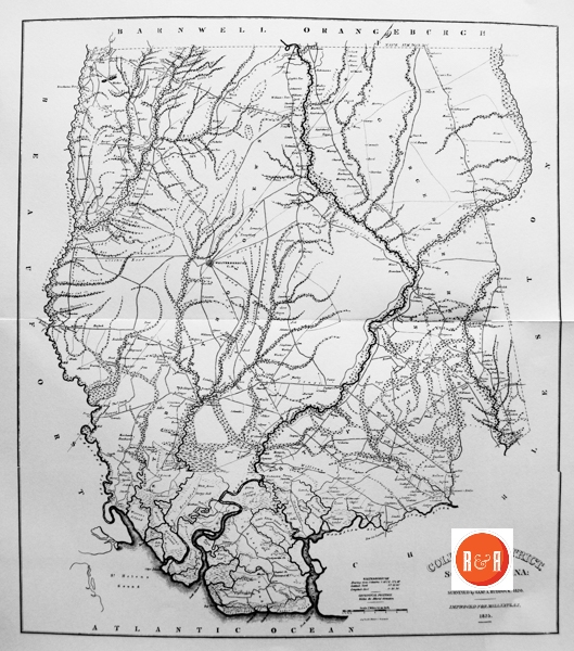
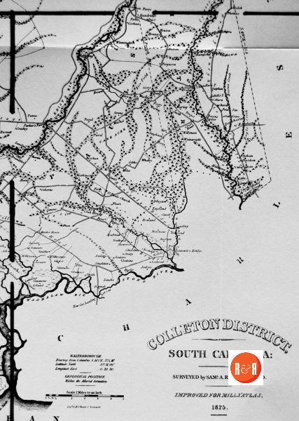
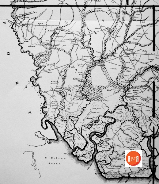
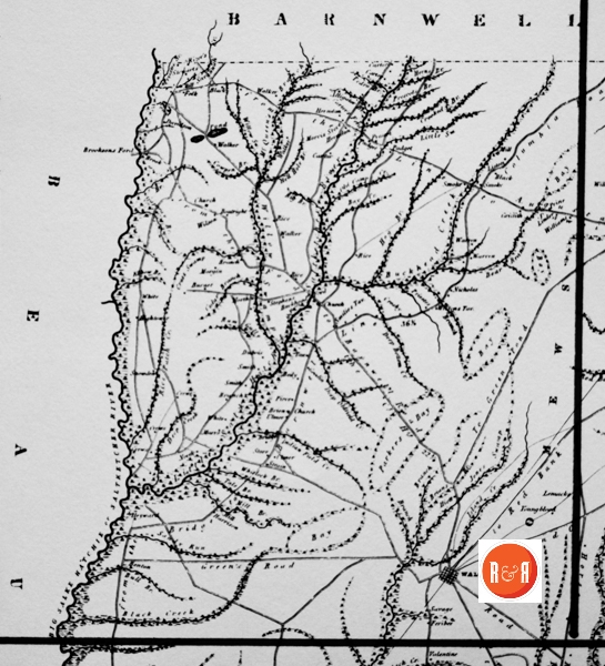
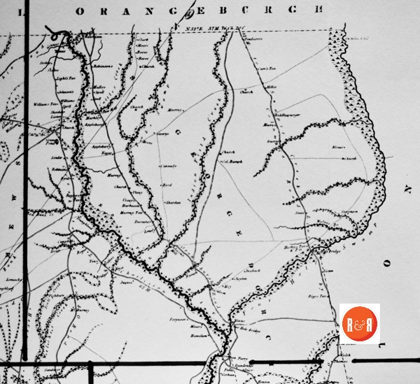
City Directories and History: Architect, Mr. Robert Mills was hired by the State of S.C. to create accurate maps of the state’s districts. In turn, he employed knowledgeable surveyors to survey the local areas, from which he created his finished maps of S.C., districts or counties. This resulted in accurate maps of roads, streams, and cities located in each. Click on the More Information / Enlargeable links, (found under the picture column), for an enlargeable county map, a history of Robert Mill’s survey of S.C. counties, written by Gene Waddell in 1980, an index to the names listed on the maps, and enlargeable quadrants for conducting in depth research.
“Samuel A. Ruddock surveyed Colleton District and was paid a total of $1,200. He received a $100 advance on 26 April, 1820, and the balance on 10 June, 1820; the survey is dated the day before the final payment. He was living in Charleston District in 1820 when the Census was taken. On 21 August, 1821, he was paid $200 for different work, this time “for reducing and copying Maps of George town and Kershaw districts, and the survey of the State Line of 1772.” His own map of Colleton reflects a flamboyant personality that got him into trouble. It is the only one of the eighteen surviving surveys which has irrelevant decorations added, including pasted-on woodcuts of an American eagle and two ships. During the heated campaign for the United States House in 1820, with Joel Poinsett, Chairman of the Board of Public Works, running against John Gettys, the former Governor, another politician named James Hamilton, who was later a governor him self, got angry enough with Ruddock to tweak his nose.” Information from: Mill’s Atlas of South Carolina – 1825, Southern Historical Press, 1980
R&R has also taken individual county maps and created a list of their recorded sites, allowing R&R’s users, faster access to historic data. Each of the More Information links opens items connected to the Mill’s map of this county. The last four are those related to Quadrants 1-4. Names within each quadrant are listed below and at the bottom of the page, is an alphabetical list, of all names shown in Colleton District, along with other counties in which the name also appears. Another excellent site to enjoy Mill’s maps is Rumsey’s Maps.
Scroll down to view the alphabetical listing of names:
| Adams – Be (2), Co. (2), E, Gr, Mar’b | Geraxdeau – Co | Reeve – Co (2), R |
| Alligator Br. – Be, Co | Gibbs – Co | Rice – Ch, Co (3), K, P |
| Appleberry – Co (2) | Ginny – Co | Rice Field – Co (2) |
| Ash – Cha, Co | Ginny’s Br. – Co | Rice Land – Co, Ge, Sp (2) |
| Ashe – Co | Givhan – Co (2) | Rice Patch Creek – Co |
| Ashe Isld. – Co | Givhan Ferry – Co | Riddlespurger – Co |
| Ashepoo, F. – Co | Glover – Co (4), O, R | Rigg’s Tavern – Cha, Co |
| Ashley River – Cha, Co (2) | Glover, Dr. – Co | Riggs – Cha, Co |
| Augusta Road – Co, O | Godfrey – Co, Mar | Ring – Co |
| Bacon – Co | Goodin – Co | Rivers – Ba, Cha (3), Co (2) |
| Bacon’s Bridge – Co | Goree – Co | Rizer – Co |
| Bailey – Cha, Co, Lau | Green – Ba, Co, E, Ge (11), Gr, H, Sp, W | Road to Charleston – Co |
| Bailey’s Island – Cha, Co | Green Pond – Co | Robinson – Ch, Co, Lan, O, Su |
| Baker – A, Co, Lan (2), Lex, P, Su | Green’s Road – Co | Roger – A, Co, E, H, Sp |
| Baker, Capt. – Co, Su | Griffith – Ch’f, Co | Roper – Co |
| Bay – Ch’f, Co (2), D, W (3) | Hain – Co | Rose – Co |
| Bay Point – Be, Co | Hamelton – Co | Rowand – Co (2), Sp |
| Bear Island – Co | Harbeson – Co | Rowland – Co, Gr (2) |
| Bearing – Co | Harley – Ba, Cha, Co | Rum Gully – Co |
| Beef Isl. – Co | Harley’s Tav. and P.O. – Cha, Co | Rumph – Ba, Cha, Co, O |
| Beily – Co | Harlock – Co, 0 | Rumph, Col. – Co |
| Bellinger – Co (2), Gr, P, Sp | Harrison – Be, Ch’f, Co, Gr, K, Lan, P | Runtowle – Co |
| Bennet – Ba, Co, Sp, Su | Hayward – Co | S win ton – Co, Ge |
| Bennet’s Point – Co | Head of Schooner Navigation – Co | Saltketcher – Co |
| Benton – Co | Hell Hole Br. – Co | Saltketcher Bridge – Be, Co |
| Big Br. – Co, Su | Hems – Co | Sanders – Co (2), D, K, Lan, Mar’b, Su |
| Big Salkehatchie or Saltketcher River – Ba, Co | Hems Br. – Co | Sandy Run – Be, Co, Lex, N |
| Black – A, Ch’f, Co (2), H, Lau | Henton – Co (2) | Savage – Co |
| Black Creek – Be, Ch’f, Co (2), D, Lex, Mar, | Herndon – Co | Savannah Creek – Co, H |
| Blake – Be, Cha, Co | Heyward – Cha, Co (2) | Schmidt – Co |
| Boatright – Co, Lex | Hightow – Co | Scull Creek – Be, Co |
| Boggy Gut Creek – Co | Hiott – Co | Seabrook – Cha (2), Co |
| Boon – Co, Su (2) | Hog Br. – Be, Co | Sheridan – Co |
| Bossua – Co | Horn – Ch’f, Co, E | Sian – Cha (2), Co |
| Bossua Creek – Co | Horse Shoe Road – Co | Sian’s Bridge – Co |
| Bowles – Co | Horse Tavern Creek – Co | Simmons – Co (2), F |
| Brisbain – Co | Hutchison Island – Co | Simmons Island – Co |
| Buckhead – Co | Indian Field Creek – Co (2) | Simms – Co, N |
| Buckhead Creek • Co, O | Jacksonborough – Co | Singleton – Co (2), Ge, K, Su, W (3) |
| Buckhead Ford – Co | Jerome – Cha, Co | Smilies Tavern – Co |
| Bull – A (2), Cha, Co, H, Mar’b | Jerome’s Inlet – Cha, Co | Smith, T.R. – Co |
| Bull Br. – Co, O | Johassa Island – Cha, Co | Smoke – Co |
| Bull River – Be, Co | Johnson – A, Ba, Cha, Co, F, Ge (4), | Smyth – Co (3) |
| Bull Swamp – Co, Lex | Johnston – Ba, Cha, Ch, Co (3) | Smyth Bridge – Co |
| Bull’s Cut – Co | Johnston Mill – Co, N | Smyth, T.R. – Co |
| Bunches – Co | Johnston – Co | Smyth, Thos. – Co |
| Bunches ford – Co | Jones – A, Cha, Ch, Co, D, E, F, Gr,: | Snowden – Co |
| Burdens Island • Co | Jongh, D. – Co | South Edisto Inlet – Co |
| Burnet – Co | Kennedy – Cha, Co, F, N, U | South Edisto River – Cha, Co |
| Burnett – Co (2) | Kenoway Isld. – Cha (2), Co | Spell – Co (2) |
| Burney – Co | King – A, Ch’f, Co, D, N, P | St. Bartholomews – Co |
| Burney Hall – Co | Koger – Co (2), H | St. George Dorchester – Co |
| Burnt Church – Co (2) | Ladson, C.B. – Co | St. Pauls Church – Co |
| Bush Br. – Co, O (2) | Lanning – Co | Stage Road to Rantowle Bridge – Co |
| Byrd – Co (2), Su | Laroche – Co | Stage Road to Rantowle’s – Co (2) |
| Cahill • Cha, Co | Lee – A, Ch, Co (2), E, F, H, K, Su (2), | Stealy – Co |
| Cahill’s Tav. – Cha, Co | Legare – Cha, Co (2), Ge | Stephens – Co (2) |
| Campbell – A, Be, Ch’f (3), Co, D, F, K, | Lemack – Co | Stevenson • Co |
| Cane Ache – Co | Lensly – Co | Stewart – Ch’f, Co, K, Lan (2), Lex |
| Cannady- Co | Light – Co | Stode – Co (2) |
| Caroll – Co | Linah – Co | Stokes – Ba, Ch, Co (3), Gr |
| Carr – Co, Ge | Linder – Co, Sp | Stono River – Cha, Co |
| Carr’s Tav. – Co | Linew – Co | Stono Swamp – Co |
| Cedar Br. – Ba, Be, Co | Linsey – Co | Stonyer – Co |
| Cedar Grove – Co | Liston – Co (3) | Store – A, Ba (2), Cha (3), Co (2), F, Gr, H, |
| Chapman – Co | Little Edisto Island – Cha, Co | Strain – Co |
| Chandle – Co, N, Su (2), U | Little Swamp – Co | Strong – Ch, Co |
| Chandler’s T. – Co | Lowndes – Co (2) | Stuts – Co |
| Chapanis – Co | Manigault – Co | Swamp Creek Line – Co |
| Cheesey Creek – Co | Marchant – Co | Swift – Co |
| Chehew River – Co | Markley – Co | Tale Br. – Co |
| Chisolm – Cha, Co (2) | Marrs – Co | Tavern – Be, Cha, Co (2), Ge, K, Lex, Mar’b |
| Clark – Cha, Ch’f, Co, E, Gr, Lan, Lau, | Martin – A, Be (2), Co, E, Ge, P, Sp | Tax Bluff – Co |
| Clark’s Inlet – Cha, Co | Matthew – Cha, Co | Thomas – Cha, Ch’f, Co, Ge (3), H, K |
| Clayton – Cha, Co | Matthews – Co, W (3) | Thompson – A, Ch’f, Co, H (2), Mar (3), |
| Clements – Co | May – Ch’f, Co (2) | To Green Pond – Co |
| Clifton – Lex | McBumey – Co | To Red Bank – Co |
| Club House – Ba, Cha (2), Co | McCloud – Cha, Co | To Round – O, Co |
| Cobum – Co | Mcllheanny – Co | Toll House – Ch, Co, Gr |
| Colleton District Co | McPherson – Co, D, Mar | Tounet – Co |
| Collins – Co, D, Ge, Mar | McQueen – Ch’f, Co | Tucker – Co |
| Columbia Road – Co, O (5) | McQueen’s Branch – Co | Tucker’s Island – Co |
| Columbia Road by Orangeburgh to Charleston – Co- | Middleton – Cha, Co, Gr, Su | Tugadoo – Co |
| Concert Hall – Co | Miles – Co (2) | Tugadoo Road – Cha (2), Co |
| Cookfield – Co | Miliken – Co | Tugaloo – Co |
| Cookfield Landing – Co | Mill – A, Be (9), Cha, Ch’f (2), Co (6), D, | Tunno- Co |
| Cowpen Br. – Be, Co | Mill Br. – Co, II, W (2) | Ulmer – Co (2) |
| Creek Line – Co | Miller – Ch, Ch’f, Co, E, F, K, Lan (5), | Utsay – Co (2) |
| Crews – Co (3) | Minal – Co | Valentine – Co |
| Crooked Br. – Co | Miner – Co | Wadmalaw River – Cha, Co |
| Crosby – Co | Minus – Co (3) | Wainwright – Co |
| Croskey – Co (2) | Mitchel – Co, Su (2) | Walers – Co |
| Crossroads – Co | Moore – Co (3), Lau, Sp | Walker – Ba, Ch, Co, E, H, N, O |
| Cross Swamp – Co | Morgan – Co | Wallace – Be, Cha, Ch, Co, Lan, N |
| Cuckolds Creek – Co | Morris – Co (2), F, Ge, N | Walnut Br. – Co, W |
| Culiatt – Co | Morrison – Cha, Co (2) | Walsh – Co |
| Cunningham – Co, K | Mulley – Co | Walterborough C.H. – Co |
| Cypress Swamp – Cha, Co | Murray – A, Cha, Co (4), Ge | Waring – Co (5), Ge (2) |
| Dacostar – Co | Murray’s Tav. – Co | Warley – Co (4) |
| Dandridge – Co | Mosquito Creek – Co, Ge | Warren – Cha, Co |
| Davison – Co (3), Y | Muster House – Be, Cha (5), Co | Warren’s Island – Co |
| Dawhow River – Cha, Co | New Cut – Cha, Co, W | Washington – Co (2) |
| Deep Creek – Ch’f, Co (2), Su | New Cut Landing – Co | Watt’s Cut – Co |
| Deep Oldfield Creek – Co | Nichols – Co | Watts – Cha, Co |
| Dent – Co, Lex | North – Co (2), P | Webb – Co, P (2) |
| Dorchester – Cha, Co | North Edisto Inlet – Cha, Co | Welche’s Creek – Co |
| Dorsey – Co | Oak Grove – Cha (2), Co, Su, U | Whaley – Cha (4), Co |
| Drayton – Co | Orangeburgh – Cha, Co, E, Lex, O, R, Su | Whillock Br. – Co |
| Dubois – Co | Orangeburgh Road – Co | White – Cha, Ch, Ch’f, Co (3), D, Ge (5 |
| Eagle Creek – Co | Osborne – Co | White House – Co |
| Eding’s Island – Cha (2), Co | Otter Island – Co | Whitlock – Co |
| Edisto Island – Co | Padgett – Co, U | Wilkey – Co |
| Edisto River – Ba (2), Co, O | Parker – Ch’f, Co, Lex, Mar’b | Wilkison – Co |
| Elbow Br. – Co | Parker’s Ferry – Ch’f, Co (2), Mar’b | Williams – Ba, Be, Ch’f, Co, E, Ge (2). |
| Fell – Co | Patrick – Co | Williams Tav. – Co |
| Fenwick – Co | Pattison – Co, Lan | Williman – Co |
| Fenwicks Island – Co | Pedro Br. – Co | Willow Swamp – Co (2), O |
| Ferguson – Cha, Co (2), Sp, W | Pendarvis – Co | Willtown – Co |
| Feribee – Co | Perry – Be, Co (4), F, K (2), Lan, R | Wilson – A (4), Cha (2), Co (2), E, F, I |
| Ferry – Be, Cha (2), Co, K (4), Lan, N (2), U,Y(S) | Pinckney – Cha, Co, Ge, O, P, U | Winningham – Co |
| Fields – Co | Pine – Co | Yon – Co |
| Fields Point – Co | Pierce – Co (3) | Young – A, Ba, Ch, Co, Gr, K, Lau, O, U |
| Firth – Co | Pond – Ba, Co, Lex (2), Su | Young’s Island – Ba, Co, O |
| Fish Pond Bridge – Co | Postel – Co (2) | Youngblood – Co (2) |
| Fishburn – Co (2) | Presbyterian Church – Cha (2), Co | |
| Flaxe – Co | Prescott – Co | |
| Flin – Co, Lan | Prescots Br. – Co | |
| Folk – Co | Price – Cha, Ch, Co (2), H, Sp | |
| Ford – Ba, Ch’f, Co, F, Ge (7), Gr, Lex, | Prier – Cha, Co | |
| Ford Barnwell Road – Co | Prier’s Tav. – Cha, Co | |
| Four Hole – Co | Priestes – Co | |
| Four Hole Bridge – Cha, Co | Priestes Br. – Co | |
| Fraser – Be, Co (3), Ge (4) | Prine – Co | |
| From Gallwant’s Ferry to Conwayborough – | Pringle – Co, Ge (2), Su | |
| From the Bridge to Barnwell Line – Co (2) | Kenoway – Co | |
| From the Line to Sawpit – Co | Racoon Island – Cha, Co | |
| Gapway Br. – Co | Radcliff – Co (2) | |
| Gardner – Co, D, K | Ramsey – Co | |
| Gates – Co, P | Rantowle – Co | |
| George – Ba, Co, P | Rantowle’s Bridge – Co |
R&R NOTE: Parker’s Ferry for John Parker who lived there as early as 1736 and operated a ferry, the Parker’s Ferry Road being the first road laid out in this county. Jacksonborough (now spelled Jacksonboro) is named for John Jackson who was granted a tract of land on the Edisto in 1701. The Round-0 section has been known as such since 1709. According to the late Mr. Alex S. Salley, it was named for the Round-0 Creek which preserved the “moniker of a famous Indian Chief who had a purple medallion tatooed on his shoulder. The English traders found it easier to call him by his ornament than by his lengthy name.” All three of the above named places are in the same general area but separated by swamps, and the same applies to the Horseshoe. Many of our early settlers referred to their home as being on the Horseshoe; in fact, many of the first settlers of Walterboro came from this area from which they were supplied by their plantations with fresh meat, dairy products, and vegetables. Edmundsbury on the Ashepoo was laid out on land given Edmund Bellinger, the second Landgrave, and named for him. Today nothing is there except a few graves that surround the site of the church.
Ton’s Crossroads, now frequently referred to as “Irons,” was named for the I’on family. Neyle’s is another crossroads named for the Neyle family, Dr. Philip Neyle who married into the Ford family and lived nearby. An unusual name is Sandy Dam, this small community a few miles from Walterboro has one of the oldest Methodist Churches in this county. Probably it was named for a small creek nearby by the same name. In 1826 there was in this county a post office named Godfrey’s Savannah with a tavern nearby named Blue House, where it is said that General George Washington dined as he traveled from Duharra, the plantation home of O’Brien Smith, where he spent the night before continuing his trip to Savannah, Georgia. No doubt Blue House Tavern was painted blue from the blue indigo that was cultivated in this section. Even today many of the Gullah Negroes have their homes either painted blue or the windows and doors are trimmed in blue “cause haant cant go obuh blue.”
Also along the Combahee were the Heyward Plantations, some of which bore European names, Hamburg, Lewisburg, Amsterdam, Rotterdam, Copenhagan, The Bluff, Myrtle Grove, Cypress. Then there were Oakland, Cedar Hill, Buncome, and Laurel Springs, all owned by the Lowndes family. Corkfield and Vineland are Marvin properties. Riverside and Hickory Hill are owned by the Chaplins; Hazelwood and Tar Bluff by the Fripps; Fields Point by the Field family; Calf Pen and Tipperary were Heyward places. Warren Island, containing a large acreage, was owned by the Warren family for over 200 years. On the Cheeha we find Social Hall and The Bluff, which was the home of James Skirving, Esq. On the Ashepoo River we find Airy Hall, originally a part of the Hutcherson grant, which is now owned by the well-known hotel man, Mr. Barringer. Next we come to The Oaks, originally a part of the Bellinger barony; the name has been changed to Lavington and is now owned by Mr. David Maybank of Charleston.
Mt. Pleasant, the home of the Croskeys for over a century, is now a part of the vast holdings of the West Virginia Paper & Pulp Company as is also Forlorn Hope and Green Meadows. About four miles from Walterboro on the highway to Charleston are perhaps a dozen houses hugging the highway which form a community known as Mashawville. This place bears the name of Henry Michaux, a Frenchman who probably lived around there in 1755. His widow, Maybank, married Dr. James Reid, and one of her daughters married into the Pringle family; thus, now we have Pringle Bend.
(Information from: Names in South Carolina by C.H. Neuffer, Published by the S.C. Dept. of English, USC)
Stay Connected
Explore history, houses, and stories across S.C. Your membership provides you with updates on regional topics, information on historic research, preservation, and monthly feature articles. But remember R&R wants to hear from you and assist in preserving your own family genealogy and memorabilia.
Visit the Southern Queries – Forum to receive assistance in answering questions, discuss genealogy, and enjoy exploring preservation topics with other members. Also listed are several history and genealogical researchers for hire.
User comments welcome — post at the bottom of this page.
Please enjoy this structure and all those listed in Roots and Recall. But remember each is private property. So view them from a distance or from a public area such as the sidewalk or public road.
Do you have information to share and preserve? Family, school, church, or other older photos and stories are welcome. Send them digitally through the “Share Your Story” link, so they too might be posted on Roots and Recall.
Thanks!
User comments always welcome - please post at the bottom of this page.


The “Sheridan” listed in Colleton District is Dr. Hugo Grotius Sheridan MD. Although Dr. Sheridan identified himself as a Medical Doctor who obtained his Medical Training at the University of Edinburgh, Scotland, he never joined the S.C. Medical Society.
Dr. Hugo Grotius Sheridan MD was the son of James Plunkett Sheridan, a brother to Dr. Thomas Sheridan (the Elder). Dr. Hugo Grotius Sheridan MD was also a 1st cousin to the Right Honorable Richard Brinsley Sheridan, who served on the Privy Council of His Majesty, King George III.
Dr. Sheridan purchased a division of the 10,000 acre Plantation of Joel Spell Sr. Dr. Sheridan built his division up to around 3600 acres. Circa 1829, Dr. Sheridan married the widow (and third wife) of Joel Spell Sr. Her name was Catherine Spears-Spell-Liston-Sheridan.
Thank you for the contribution! It was a pleasure to have met you on the tour and would love to receive additional contributions of data. Merry Christmas!