The Yorkville Enquirer reported on Jan. 13, 1870 – “The steam ship fleet in Charleston has been increased by two new ships, the South Carolina and the Tennessee. They will form a weekly line between New York and Charleston.”
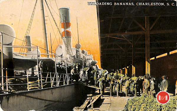
The Yorkville Enquirer reported on Oct. 22, 1885 – “Mr. J. C. Chaldwick of NY will establish a special line of steamers to carry fruit between the West Endies and Central America to Charleston. They have leases a wharf and will make Charleston the distribution center to northern and western markets.”
City Directories and History: Charleston Wharves, 1866
(Information in part from: Names in South Carolina by C.H. Neuffer, Published by the S.C. Dept. of English, USC)
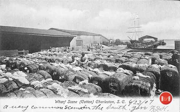
……… The wharves of Charleston have undergone more change than have her buildings and streets. From her earliest settlement she must have had wharves of a kind. Trade by sea was to the Proprietors her reason for being. Her shipyards and her shipping lists through the long years are proof of this. In research of the subject the most complete list of wharf names is that which I find in the City Year Book for 1936. This story is based upon an article which appeared in the Daily News,Farthest south and nearest the Battery, the old Southern Wharf flung its twin piers where Cooper River rushes into the harbor—a location affording no protection from wind or water. At an earlier date, described as “Mr. Teasdale’s time,” upon it were six octagonal buildings. Five large warehouses could hold 15,000 bags of cotton and tierces of rice. Its name was of course given because of its location. August 20, 1866. Next to it and bearing another descriptive name was the Commercial Wharf, whose two piers were known as North Commercial and South Commercial. In 1866 it was and had been for eighteen years under management of Mr. E. C. Holland, “a veteran wharfinger, who succeeded Mr. Aldrich.” The capacity of its warehouses was said to be “4000 bags of sea islands (cotton) and 2500 tierces of rice.” Upon North Commercial Pier were placed Confederate batteries, and the wharf was consequently a target for the Union guns on Morris Island and emerged from the war severely damaged. Vanderhorst Wharf—spoken of also as General Vanderhorst’s Wharf—was named for General Arnoldus Vanderhorst. A plat of August 1804, made by Charles Purcell, shows it as his property. It had but one pier. This was unusually long and was also fortified during the siege of Charleston. Storage capacity of this wharf ran from 4000 to 5000 bags of cotton or tierces of rice. Adger’s Wharf, with double piers, stood next upstream. Pier #1, which had been used before the War of the Secession by the “splendid steam fleet of the Charleston and New York Packet Company, after the war used by the Leary Line of New York steamships.
The Year Book gives this colorful description of it: “As we stood on the bulkhead, where, in the bright days of yore, the pioneer, the old Southerner with her incomparable captain Mr. Berry, was wont to throw her lines ashore, our thoughts carried us back to those pleasant days when the red signal from the Exchange told us that the Columbia, the Adger, or Nashville [sic] were below, on those never- to-be-forgotten Mondays when we stood in the shade, watch in hand, waiting for Berry’s or Dickinson’s signal gun, fixed opposite the pier head, to fix the time to a minute.” Continuing in the leisurely style of a day when sentences were as long as a wave rolling in from sea and commas as cheap as were then grist and bacon: Pier #2, Adger’s North Wharf, had “a massive sea wall of solid granite …”The old cobblestoned roadways leading from East Bay down to these piers have been kept open under street names of Adger’s North Wharf and Adger’s South Wharf. Charming houses upon them and fronting on Cooper River make a breezy development as colorful as Rainbow Row. an “accommodated Roach’s New York Schooner Line.” Its immense three-story building of brick could hold 30,000 bales of cotton. This building had “dead walls” running from its foundation to reach above its roof. Thus guarded in case of fire, it had the advantage of lower insurance rates. This important wharf was developed by and named for the merchant James Adger and remained long under Adger family management. It stored some rice and sea island, but mostly the regular short staple cotton. Cotton brokers called “videttes” haunted it, and fifteen had offices upon it. An old saying on the waterfront was: “If you wish to see a cotton broker do not go to his office. Follow the beaten track along the wharves until you find him in some sample room.”
Adjoining Adger’s Wharf was Boyce’s Wharf, named for the Honorable Ker Boyce. This had two piers and sixteen counting rooms. Its factors were Boyce, Henry and Walker, then Martin, Starr and Walker. During the War it was converted into a shipyard and at least one iron-clad gunboat was there built. Consequently it was damaged by enemy fire and its docks filled up with mud from disuse. At the war’s end we have a picture of the dredge Hercules The name Atlantic Wharf is both descriptive and appropriate. Situated just north of Boyce’s, it was at this time largest of the city wharves, having four piers, nine large warehouses, two large sheds, and accommodating 100,000 bales of cotton. Willis and Chisolm then held a five year lease and superintend working to restore it and we are told that “Mr. Leitch, the wharfinger, can take in 15,000 bales.” Superintendent was H. C. Robinson. From it steamships sailed weekly to New York, Baltimore, Boston, Florida, the Pee Dee [sic] country.
Kerr’s Wharf had been at an earlier date known as Dewees Wharf. From the heirs of William Dewees, Jr., factor, it was conveyed “to William Patton by deed, February 1, 1850.” Patton sold it in 1854 to Thomas J. Kerr. “Kerr was a merchant and in the 1850 s was living at 1 Society Street.” Kerr’s Wharf ran from East Bay to Cooper River at the foot of Queen Street. It had but one pier and was southernmost of what were spoken of as “the Central Wharves” of the city. Next, and jutting from the foot of Vendue Range, was Brown’s Wharf, named for George W. Brown, a commission merchant who made his home at 8 Montagu Street. Formerly known as Gibbs Wharf, it was conveyed by deed of April 1846 to Brown. Here called and cleared ships of Street’s Baltimore Steam Line. Just north, the Accommodation Wharf was owned by Ferguson and Holmes. Badly damaged during the war, it made a good recovery and was the first wharf repaired after the war. Its fourteen counting rooms were all occupied by factors, and from it steamers sailed for Georgetown, Pee Dee [sic] and Savannah.
The Central Wharf—which like the accommodation bore a descriptive name—is spoken of in Next to this was the Custom House Wharf. Its approximate location is the foot of Market Street and it is still used by the United States Government. The Daily News as “head and front of the cotton trade.” In the hands of Fraser & Company, Dulin & Ulm and other management, it handled 20,000 bales in a morning’s work. Ships from the East Indies, Liverpool, le Havre, Bremen, tied up at the bollards of its two piers. But, chosen for the dangerous honor of mounting that artillery piece known as “the monster gun,” it was turned into a battery and blocks of buildings surrounding it were tom down. Just north of this was the Market Wharf, a public ferry terminal. It must have been a busy wharf, since the Cooper then lacked bridges and the next ferry appears to have been Dover-Calais on Charleston Neck. At this date an immense mud flat stretched north and west of the Market Wharf. It forbade passage along the waterfront, and people on their way to the wharf upstream were obliged to go out to East Bay and from there go in again.
These next wharves belonged to the Dry Dock Company. We are told of them that “from Pier #1, the Isabel, once the pride of our city, made her ever- punctual trips to Havana.”
Property of the Union Wharf was bounded by East Bay, Pinckney and Concord Streets and Hard Alley. It had but one pier. Leased by Courtney and Trenholm, it was under management of Captain James Copes. It was swept by the great fire of 1861.
Just upstream, the Palmetto Wharf bore an appropriate and descriptive name. Whether it honored the state tree or the wood used in its construction I do not know. At it was moored the dry dock of Messrs. Marsh and Sons, ships carpenters. Next to the Palmetto and at the foot of Hasell Street lay Patton’s Wharf. Once known as Eason’s Wharf, it was sold by Robert Eason in 1836 to William Patton, John Haggerty, James R. Allan and Charles Morgan. Patton, who owned a full half, shortly afterward bought the other half from his partners. Here docked the Savannah and Charleston Steam Packet Company. Three of their packets were named the Gordon, the Cahoun and the Cecile.
The Cecile I have found mention of Geyer’s Wharf near the Southern Wharf and of Rose’s Wharf somewhere around the foot of Guignard Street. Whether they were separate wharves sandwiched in between the ones mentioned above, or whether the names relate to a period of ownership of two of these same wharves, I have not discovered. The wharves, like other property, changed hands. Today’s list of those along Cooper River would be vastly different from this list of 1866. Trout and Armstrong were here in charge, and the wharf owners were Messrs. Lafitte. I find no record of sea lanes along which their packets drove; but some must have gone to and returned from northern ports, because some of their sheds stored that cargo prized by southern housewives—ice. Others held lime and cement. But one hundred and one years ago these were the Charleston wharves, extending north from White Point to Hasell Street. Most of them are gone now— not like the snows, but like the tides and winds of yesteryear. With them has gone a picture which cannot come again: a picture of cotton brokers with high hats and cigars, waiting watch in hand for a steamer’s whistle or a signal gun … a picture of tall sails leaning as they cleared the harbor bar, deep laden with the silky, long staple sea-island cotton and with tierces of Carolina rice.
Acknowledgments: I wish to express my appreciation for the kind assistance of A. J. Tamsberg, Clerk of the Council, City of Charleston; Charleston Library Society; and City Yearbooks of Charleston. —DRAYTON MAYRANT
(Information from: Names in South Carolina by C.H. Neuffer, Published by the S.C. Dept. of English, USC)
Stay Connected
Explore history, houses, and stories across S.C. Your membership provides you with updates on regional topics, information on historic research, preservation, and monthly feature articles. But remember R&R wants to hear from you and assist in preserving your own family genealogy and memorabilia.
Visit the Southern Queries – Forum to receive assistance in answering questions, discuss genealogy, and enjoy exploring preservation topics with other members. Also listed are several history and genealogical researchers for hire.
User comments welcome — post at the bottom of this page.
Please enjoy this structure and all those listed in Roots and Recall. But remember each is private property. So view them from a distance or from a public area such as the sidewalk or public road.
Do you have information to share and preserve? Family, school, church, or other older photos and stories are welcome. Send them digitally through the “Share Your Story” link, so they too might be posted on Roots and Recall.
Thanks!

User comments always welcome - please post at the bottom of this page.


Share Your Comments & Feedback: