The Yorkville Enquirer of April 10, 1879 reported – “Mrs. E.L. Minter, a daughter of Morrison Russell of Bullock’s Creek Township has left for her home in Sterling, in Weld Co., Colorado where she and her husband now live. She has been home in York County for four months to care for her mother who died during her stay.”
The Yorkville Enquirer of March 23, 1887 reported – “The school at Shady Grove was resumed recently with Mr. L.A. Abernathy as teacher. Attendance is low due to the prevalence of measles.”
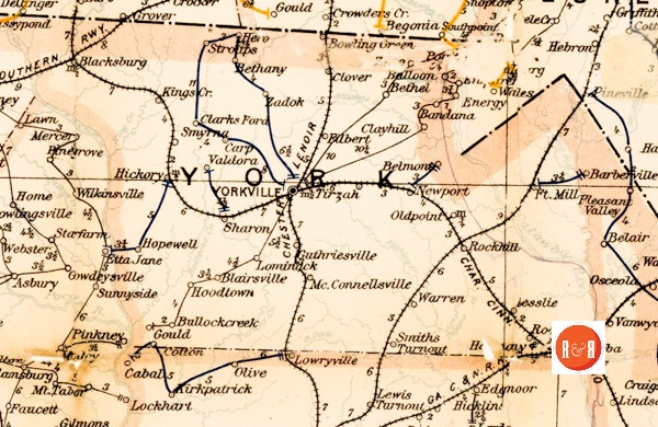
ROBINA POST OFFICE: This Post Office was established at the residence of Emmitt Lowe on Howell’s Ferry Road, six miles west of York. It began service in April 1889.
THE RUSSELL SCHOOL: Established in 1818 by Robert Young Russell when he was eighteen, this school continued for no more than two years, ending when Russell decided to study for the ministry. Classes were conducted in a log building on the farm of his stepfather, James Hogg, in what was later known as the Blairsville community. A more exact location for the school is at the end of Sunset Meadow Lane near the present home of Jack Kerr. Any attempt to connect this school with the Blairsville Academy that was established in 1830, is incorrect. They have no relationship other than Russell taught at both.
SANDERSVILLE: This small agricultural community located on the York-Chester counties line off South Burris Road no long exists. The post office in 1860 was serving a large number of residents ranging from Bullocks Creek, to near McConnells and toward Sharon. That year only Matthew White was listed as an area merchant. The New Bethel Baptist Church was located in Sandersville; the cemetery has been cleared in the past years. In 1886 Cedar Grove Academy sponsored a picnic at Sandersville honoring its teacher Miss Jenny Brawley. Forty-four children attended. In the 1880’s William Minter, grandfather of William L. Hill, Sharon‘s dead of merchants, was operating a store. After Minter died, Hill operated the business and moved the business and home to Sharon in 1889. The census reports a mercantile business operated by Matthew White. The cemetery of the Bethel Baptist Church still exists.
SANDY BRANCH: Runs southward across Wilkerson Road that connects Salem Irene Bridge Road and Sawmill Road.
SHADY GROVE METHODIST CHURCH: In 1873, J. H. Good gave one and a quarter acres of land along with Misses Mary, Milly and Susan Hayes who gave one and three-quarters acres to a Methodist congregation. While the meetinghouse was being constructed, the people met in a nearby log cabin that was located in an oak grove just above the present site. The first building was completed in 1874. The second meetinghouse was constructed in 1908 by Mr. Clary E. Feemster and in 1946-1947, the third building was erected by Mr. W. D. Hardin and completed by Mr. Barner Horton. In 1974, Shady Grove Methodist Church became a station church and is presently having worship services twice a month. The church is located on Highway 97 near the community of Hoodtown.
SHALLOW FORD: An ancient ford located on Bullock’s creek on Hamilton’s Ford Road west of the Bullock’s Creek Presbyterian Church. The name was derived from the fact that the creek was so shallow at that point it was suitable for walking or crossing on horseback.
SHARON HEIGHTS: Summit of the first hill on Pratt Street in Sharon. The number was mentioned in a letter dated 7 October 1922, from W. L. Hill of the Planter’s Bank to Mrs. S. T. Ferguson, Jr., it read: “The Stephenson property is splendidly located, up there on what is known as Sharon Heights, one can have a perfect view of the whole town, convenient to Church and not too far from school.”
SHARON VALLEY: Former name of Sharon. A post office by this name was established in the area of the Sharon A.R.P. Church in 1856 with Andrew F. Love as Postmaster.
Stay Connected
Explore history, houses, and stories across S.C. Your membership provides you with updates on regional topics, information on historic research, preservation, and monthly feature articles. But remember R&R wants to hear from you and assist in preserving your own family genealogy and memorabilia.
Visit the Southern Queries – Forum to receive assistance in answering questions, discuss genealogy, and enjoy exploring preservation topics with other members. Also listed are several history and genealogical researchers for hire.
User comments welcome — post at the bottom of this page.
Please enjoy this structure and all those listed in Roots and Recall. But remember each is private property. So view them from a distance or from a public area such as the sidewalk or public road.
Do you have information to share and preserve? Family, school, church, or other older photos and stories are welcome. Send them digitally through the “Share Your Story” link, so they too might be posted on Roots and Recall.
Thanks!

User comments always welcome - please post at the bottom of this page.


Can someone provide precise directions to the path to get to New Bethel Cemetery? I know where the property is located by using the York Co GIS mapping system to locate the little plat of land owned by Lowrys Baptist Church, but I don’t know which road has the path that leads to the cemetery. I’d also like to know who to contact to get permission to visit the site and if using a 4 wheeler to get there is ok. I once found a website that described the Lowrys church cleaning up the cemetery, but that website appears to be gone as I can’t find it any longer.
We suggest your contacting Michael Scoggins, York County’s Curator of History – at the Historical Center in York, S.C. He has maps to the sites and may be able to provide added data.
Thanks, I’ve had someone else suggest I contact him as well.