City Directories and History: R&R has divided the 1939 SCDOT map of Spartanburg County into (35)
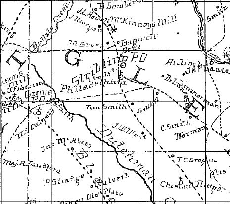
Note the location of Chestnut Church (lower Rt). Sloan – Epton’s Spartanburg Co Map ca. 1869. Courtesy of the Cobb Collection – Other Side of the River Museum, 2016
sectional maps. Many of the individually listed schools and churches shown on this section are pictured. However, in many cases, the individual site also has its own post on R&R, which often provides added information and image. Be wise and use the search function to locate all of the entries for this and other homeplace listings.
Click on this lick to view the original county map: SCDOT MAP
Stay Connected
Explore history, houses, and stories across S.C. Your membership provides you with updates on regional topics, information on historic research, preservation, and monthly feature articles. But remember R&R wants to hear from you and assist in preserving your own family genealogy and memorabilia.
Visit the Southern Queries – Forum to receive assistance in answering questions, discuss genealogy, and enjoy exploring preservation topics with other members. Also listed are several history and genealogical researchers for hire.
User comments welcome — post at the bottom of this page.
Please enjoy this structure and all those listed in Roots and Recall. But remember each is private property. So view them from a distance or from a public area such as the sidewalk or public road.
Do you have information to share and preserve? Family, school, church, or other older photos and stories are welcome. Send them digitally through the “Share Your Story” link, so they too might be posted on Roots and Recall.
Thanks!

