CONGAREE HERITAGE MAP BY MAYHUGH – PDF
A partial reprint of an article found in: (Information from: Names in South Carolina by C.H. Neuffer, Published by the S.C. Dept. of English, USC)
City Directories and History: Jackson Creek, which had its head in the upper part of the county, cut through lands of Richard and Philip Jackson according to their plats recorded in 1740. Early dwellers gave these waterways distinctive names. On Mills’ map of Richland District surveyed by Marmaduke Coate in 1820 we find the following names: and is sometimes known as Patrick’s Creek. It flows into Gill’s Creek due east of Columbia and loses its identity at that point. Gill’s Creek was named for James Gill Mill Creek was first known as Raiford’s Creek from Philip Raiford who settled on it, who settled on its banks.
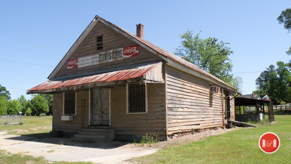
Wateree Store: Courtesy of Ann L. Helms – 2018
On later maps it appears as Hays Mill Creek, Cedar Creek cuts across the lower part of the county and flows into the Congaree River after joining Tom’s Creek. Obviously Cedar Creek got its name from the cedar trees along its banks. Tom’s Creek was likely named for an early settler and Carter’s Creek, running almost parallel to the Wateree River, empties into the Congaree River just above the fork. It was probably named for Henry Carter on whose plat it is shown. Then again as Mill Creek.
Colonel’s Creek has its head near the Kershaw County line and cuts across the sand hills as it flows towards the Wateree River. Colonel Henry Fox established himself near the mouth of this creek and apparently it took its name from his title. Later maps show Cabin Branch which flows between Mill and Cedar Creeks. German settlers had their cabins along its banks and from these it received its name. Several plantations in this area are named Cabin Branch.
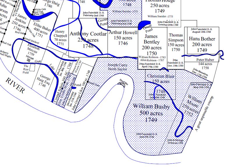
Small section of the Heritage Congaree National Swamp Map by Mayhugh – 2015 (See PDF this page.)
Tararara Branch below Mill Creek was on the property of Colonel Wade Hampton. Other early names are: Pole Bridge Creek, Rives Creek, Griffins Creek and Little Creek; Dry Branch, Piney Branch and Horse Pen Branch. It is said that Mrs. Sarah Thomas Hopkins raised horses on the latter branch for General Sumter’s and General Marion’s armies and from this it got its name. Grist and saw mills, so necessary to the establishment of the settlers, were built early in the life of the county. On Mills’ map we find two Hampton mills, and James Hopkins, the Adamses, the Bynums, the Thomas Edmunds, the Garners, the William Howells, and the J. L. McLaughlins all had mills.
As crops were harvested, grain milled, and wood cut, transportation became a grave problem. In order to carry their commodities to market at Charleston and to the upcountry, public roads and ferries, both private and public, came into being. The roads which had their beginning as Indian paths or trails were gradually improved and those that led to the ferries and townships became public highways. In 1802 John Drayton described the roads of the state as well adapted to transportation and travelling, even to the mountains and “hence wagons find no difficulty in coming from the upper country; bringing with them, the commodities of that distant region.” He further stated that in the upper country the water courses were crossed by bridges and ferries.
On Mills’ map (1825) the principal roads from Columbia through Lower Richland were the road to Stateburgh, later known as the Garner’s Ferry Road, the Bluff Road running along the edge of the Congaree Swamp and terminating at the fork of the rivers, and the Camden Road along the edge of the Wateree Swamp to the fork.
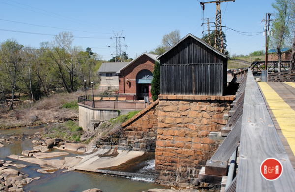
The rivers had been clogged by a great “raft” of trees and in spite of the fact that a law had been passed in 1726 making it unlawful to cut trees and throw them in the river,22 it was necessary to have commissioners appointed in 1753 to have the Wateree cleared of the “rafts and other obstructions and to make the river navigable by cutting a water passage in any way which they deemed expedient.” In 1765 it was further enacted that all male inhabitants from the ages of sixteen to sixty, living on either side of the river within ten miles, would be required to keep it clear by removing obstructions and they were to keep the water passage in repair as the commissioners found necessary. As a result, boats ran on the Congaree and Wateree to the fall line, but due to the improvement of the roads most travel was by land. For the use of the public ferries it was decreed that the governor or commander in chief of the Province, minister, people going to and from muster of the militia, all persons in time of alarm, messengers of the government and free Indians should be exempted for paying ferriage for themselves, their servants and horses.
Those using the ferries were to pay as follows: “For a foot passenger, one shilling and three pence; for a single horse, one shilling and three pence; for a man and a horse, one shilling and six pence; for meat cattle per head, ferried or swam, twelve pence; for calves, sheep or hogs, twelve pence, like money per herd; for a wagon and team of horses, with drivers, twenty-five shillings. All of which rates and prices shall be paid and received from all persons (Indians in amity with this government excepted), at all times, except in times of alarm when the ferries shall be free; and also except such person and persons who shall be going to or coming from divine service, who shall pass and repass the said ferries, respectively, free.”
There were a number of private ferries on both rivers but the public ones shown on Mills’ map of 1825 were McCord’s Ferry on the Congaree and Brisbane’s or Garner’s Ferry on the Wateree. McCord’s Ferry, formerly called Wright’s, was established by John McCord in 1766 for fourteen years and took its name from its owner. Brisbane’s Ferry was named for Adam Fowler Brisbane who on November 16, 1783, had the ferry established at a place formerly called Simmons Upper Ferry. This was for fourteen years, and in 1817 it was established for seven years more. The Garner family was evidently living on land adjoining the ferry, since John Garner died in 1792 and is buried on the place. It is said that he ran the ferry and the inn which was known as Garner’s.
In 1840 Sarah Garner, a descendant of the early Garner, willed to Thomas Garner three hundred acres of land and the ferry. There is no record of when the name was changed from Brisbane’s to the road from Columbia, first called “the road to Stateburgh” Garner’s Ferry took the name of the Ferry. Other early ferries which evidently disappeared before 1825 were: Francis Goodwyn’s called Good-Garner’s Ferry Road.
Goodwyn’s Ferry but originally known as Horseman’s Ferry on the Congaree established for fourteen years in 1783 and Joshua English’s Ferry on the Wateree established in 1791 for fourteen years. It was called English’s Ferry. A number of communities with indefinite boundary lines make up Lower Richland County. Some of the earliest ones have practically passed out of existence
but they played an important role in the history of the section.
Lykesland or Lykes as it is called by the Atlantic Coast Line Railroad is in the Mill Creek area, about seven miles below Columbia. It was the home site of Major Frederick Lykes who settled there early in the nineteenth century. However, John George Lykes took lands on the east banks of the Congaree and it could have been named for him. His royal grant for one hundred acres was dated January 17, 1748. Hopkins, lying between Mill and Cedar Creeks, was originally called Hopkins Turnout. It received its name from John Hopkins of Virginia who obtained a royal grant in 1764. The South Carolina Railroad had a turntable at this location before the line was completed to Columbia. Here the train turned around, making its way back to Charleston. Travellers proceeded to Columbia by stagecoach until about 1842 when the railroad was completed.
Taking the name of the Greek goddess of wisdom, Minervaville. When David T. Hopkins made his will in 1836 he instructed his executors to buy lands in this location, to be used as quarters for his wife’s slaves. It was thee site of the Minerva Academy. After the academy ceased to operate, the lands of Minervaville were gradually absorbed by Hopkins. This was done and the section, named for his wife, was called Fanny Hopkins.
Horrell Hill, the next community below Hopkins on the Garner’s Ferry Road was originally called Myers Hill since the lands there were first owned by William and Frederick Myers. In the middle of the nineteenth century Thomas Horrell and his son lived at the foot of the hill. It is said that the first county court house was at Myers Hill. Congaree, lying between Cedar and Tom Creeks, took its name from the river which runs to the south of this section. Originally called the Fork it was changed to Grovewood. When its name became confused with Greenwood and mail was being misspent, the local families asked to have it called Congaree.
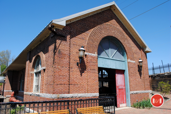
Gadsden, below Weston on the Bluff Road, bears the name of the illustrious Charlestonian, James Gadsden (1788-1858) who for many years was president cf the Louisville, Cincinnati and Charleston Railroad. The station at Gadsden, built in 1840, was the first railroad station in Richland County. From this point a stagecoach line was operated to Columbia until 1842 and to Camden until 1849.
Located between Congaree and the Bluff Road, was named for William Weston who came into the section about 1750. Kingville, a railroad junction on the edge of the Congaree Swamp just above the fork of the rivers, was a thriving town when the South Carolina Railroad built its line from Charleston to Columbia. In recent years it has become almost a ghost town; only a few houses and abandoned building remain there. Because of its preeminence as a railroad junction it was called Kingville.
To the east of Kingville is Wateree on the border of the swamp lands of the river for which it is named. Eastover, so called because it is over to the east of the Congaree, has another tradition that it received its named because of its location east of the Weston place. Acton, in the vicinity of Eastover was an early railroad station and the location of the Mathew Richard Singleton home and plantation, Kensington. As time passed, many families were living along No explanation of its name has been found.
Colonel’s Creek and by 1831 it had one of the two post offices in the county, the other being at Columbia. The Sand Hills adjoining the Wateree Swamp had no formal name but in this high section many families built summer homes. Now the houses that are left have become year-around dwellings.
Stay Connected
Explore history, houses, and stories across S.C. Your membership provides you with updates on regional topics, information on historic research, preservation, and monthly feature articles. But remember R&R wants to hear from you and assist in preserving your own family genealogy and memorabilia.
Visit the Southern Queries – Forum to receive assistance in answering questions, discuss genealogy, and enjoy exploring preservation topics with other members. Also listed are several history and genealogical researchers for hire.
User comments welcome — post at the bottom of this page.
Please enjoy this structure and all those listed in Roots and Recall. But remember each is private property. So view them from a distance or from a public area such as the sidewalk or public road.
Do you have information to share and preserve? Family, school, church, or other older photos and stories are welcome. Send them digitally through the “Share Your Story” link, so they too might be posted on Roots and Recall.
Thanks!