From the Rock Hill Herald of January 19, 1888:
There is a proposal from a textile factory at Catawba Falls in Chester County. It could be served by a rail line to Bascomville to connect with the Cheraw & Chester Railroad of to a point on the new Georgia, Carolina and Northern Railroad. The proposed corporators are F. H. Barber, J. H. Smith, J. L. Agurs, J. J. Stringfellow, W. S. Gregg, J. K. Henry, G. W. Gage, James Gayden, W.M. Lester and Dr. Sam Anderson. A capital stock of $500,000 is being sought to be invested in erecting and equipping a factory and in cleaning out the Catawba River Canal built around the Catawba Falls many years ago by the State of South Carolina. It has been idle since being abandoned 62 years ago. The canal stretches nearly 2 ½ miles and has a fall of 135 feet. The stone work done there by Scotch rock masons is magnificent and is in a perfect state of preservation. Operations were commenced in 1811 and this part of the work was completed in 1825 and boats passed through it. Greater lengths of the canal up on the river were never finished and after spending three million dollars, the whole work was abandoned. Rocky Mount nearby will become the Lowell of the South.
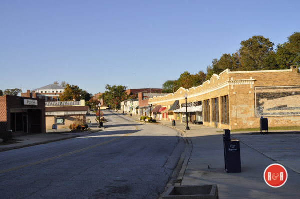
City Directories and History: Names included in this account represent places and streams found in an area of Chester County limited for the most part to a strip five to seven miles wide, and reaching from the outskirts of the city of Chester to Great Falls. In these modern days S. C. Highway 97 carries traffic to and froe between the two cities. In an earlier time this important link was known as the Rocky Mount Road or Beckham’s Road. Names in Southeast Chester County This is the land where the Rocky Creek Irish, sturdy followers of John Calvin, settled and on which their imprint will forever remain. It is the land to which small groups of Covenanters from Scotland and Ireland came. These latter people, however, could not stay for long because their consciences rejected slavery. And so in the 1820-30 period most of them departed for the Midwest. Nevertheless, more than a faint trace of these Covenanters is found in Chester County today.
-
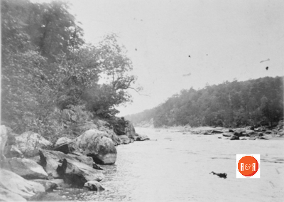
- Rare view of the river at Great Falls, S.C. prior to being damned to produce hydroelectricity. Courtesy of the L. Pettus Collection – 2015
-
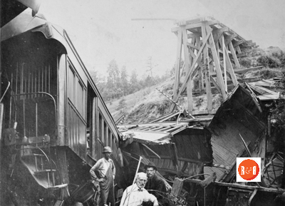
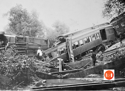
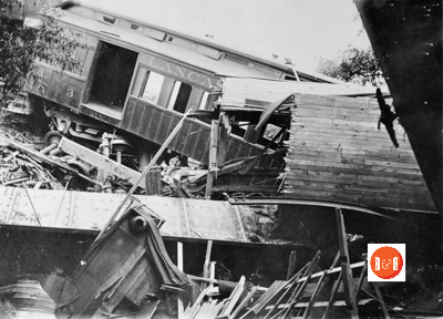
- Images of the train wreck near Chester, S.C.
It might be well, with due respect to other denominations, to also say that this is Presbyterian country. And finally, this is the area where my Bigham forefathers lived. My father was born here in Rocky Creek Irish country, and from the earliest days he regaled his children with stories about the land and its people. Beckhamville, which is hardly more than a dot on the map these days, was once far more important and prominent than the neighboring town of Great Falls. Here a battle was fought in May of 1780 between a band of 200 Tories on one side, and 33 Patriots on the other. It was a decisive victory for the patriot group commanded by Capt. John McClure. He happened to be a nephew of a truly renowned local fighter “Magistrate” named Justice John Gaston. In fact, practically the entire contingent of Americans that day was composed of Justice John’s nine sons and assorted relatives. Three of the fighting Gaston brothers were later to lose their lives at the Battle of Hanging Rock over in Lancaster County.
R&R HISTORY LINK: BATTLE OF HANGING ROCK (LANCASTER CO SC)
In colonial days and even after the Revolution, what is now Beckhamville was known as Beckham Old Field. No town could be more aptly named than Great Falls. An interesting notation on the Mills Atlas of 1825 points out that the Catawba River, as it flows along the southeast edge of Chester County, falls 178 feet in eight miles. What more significant name could be given the industrial community which was later developed along the river ? Rossville is a crossroads, a community, a state of mind, and a mere shadow of what it used to be. Here the highway between Chester and Great Falls is intersected by SC Highway 901, an important artery from Richburg to Winnsboro and points south. James Brown Ross, a settler who appeared in the early 19th century and is described in various accounts as “a prominent churchman,” gave his name to the community. Once the site of fine homes, churches, schools, cotton gins, and other indicators of a prospering agricultural economy, Rossville is no longer an important place. Local natives may want to disagree with this opinion but their disagreement will be out of civic pride more than anything else.
There is some evidence that before Rossville came into being there was an earlier crossroads or geographical point known as Neely’s, and near this location a Methodist church called Ebenezer will soon be observing its bicentennial. Peden’s Bridge Road is a well-used thoroughfare of the farm-to-market variety which leaves Highway 97 on the outskirts of Chester, wanders through well-kept grazing lands and also wilderness country, and in about ten miles or so crosses Rocky Creek. What is described as “the old Peden house” once stood in splendor on the opposite side of the creek. Apparently the original Pedens were Peggy and John who died in 1788 and 1791, respectively, and are buried in what my people used to frequently refer to as the Strong graveyard on Little Rocky creek. There are no Pedens in Chester County today.
Peden’s Bridge Road is also called the Ridge Road, and for good reason. There ate elevations along its meandering route where one can see the proverbial country mile, and many more.
The present Purity Presbyterian Church in Chester began as Bull Run Church, and may have been organized as early as 1770. Although the church moved into town in 1839, the term Old Purity continues in common usage and usually refers to the ancient cemetery at the former site. This hallowed piece of ground, said to be the geographical center of the county, is located near where Peden’s Bridge Road joins the main highway. Why the name Purity? Well, many surmise that the early founders (being determined Presbyterians) desired above all else that the Gospel be preached among them in all its purity.
Pleasant Grove Presbyterian Church, as expected, is located in a grove of trees about five miles from Chester and a quarter mile off the highway. It was organized in the comparatively late year of 1847. Apparently this place of worship was originally established as an extension of historic Catholic Presbyterian Church ten miles to the southeast. In fact, Pleasant Grove in early days was often referred to as Upper Catholic, as well as White’s Church and the New Church. The name Pleasant Grove was also given a nearby school which flourished around century. The teacher was usually the minister’s wife with him serving as substitute.
R&R HISTORY LINK: PURITY CHURCH OF CHESTER
The Brick Church, a Covenanter stronghold, once stood near the present site of the Chester lookout tower. (Natives always make reference to the fire tower rather than the lookout tower.) Whatever the proper name, the tower serves as a familiar landmark, a sure direction finder, and a reliable point of reference. No trace of the Covenanter church can be found today, but the cemetery used by these hardy people is nearby. It is in good condition, fairly accessible, but hidden away in pinelands. Strangers should use a guide who will inevitably start out by explaining that the old cemetery is “near the fire tower.” There are twenty-five marked graves and several unmarked ones in the Covenanter cemetery. Five ministers are buried here, and family names on tombstones have a Scotch-Irish ring: McMillan, McKinner, Riley, King, Nisbet.
Bighamtown was located a few miles southwest of Richburg and a couple of miles away from Peden’s Bridge across Rocky Creek. Although its site is a little outside the prescribed area about which I am writing, inclusion of the name in this account is obvious. However, the Bighams who gave their name to the place were largely unknown to my side of the family.
Wellridge is a community on Highway 97 some ten miles from Chester but, like Rossville, most of its best days are in the past. The name remains familiar because of a voting box there, but a single combination service station and store and an abandoned schoolhouse are about all that’s left to Wellridge today. The community is of special interest to me because my father, having been taught at home until he was 14, then entered the Wellridge school in preparation for college.
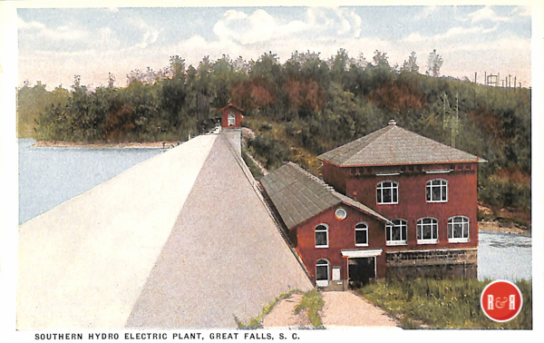
Great Falls power plant. Image courtesy of the AFLLC Collection – 2017
In the midst of old Chester names there is a new one. Rucker’s Crossroads is on Highway 97 about five miles out of Chester and near Pleasant Grove Church. Harry Rucker was born in the heart of the town of Lexington, left Columbia in the midst of a streetcar strike fifty four years or more ago, took up employment in Chester with Springs Mills, and eventually went in business in the form of a general store at the crossroads which today bears his name. He never plans to return to Lexington or Columbia, and his family name fits a little more comfortably into the Rocky Irish country than it once did.
Gold Mine Church is on the highway a mile or two below Wellridge but this Black meetinghouse has been abandoned long ago. If ever gold was mined in Chester County, it was in the western part, so that chances of ever tracing the name of Gold Mine Church are Creek. There was once a rather famous school in Tip Top, and some older Chester people remember getting “a pretty good” education there.
All the territory about which I have been writing is drained by Rocky Creek and its many branches. To a great extent the upper and lower systems of this stream have profoundly affected the lives and customs of the inhabitants ever since the sternly religious and hard working Scotch-Irish first appeared on the scene. The upper stream, fed by such smaller creeks as Bull Run and Bull Skin as well as many others, is shown on maps at Rocky Creek. It is sometimes called Big Rocky Creek and by the time it passes under Peden’s Bridge it has become a respectable stream. Headwaters of
Rocky Creek are as far north in the county as the town of Lowrys.
The lower stream rises in the neighborhood of Hopewell Associate Reformed Presbyterian Church, which in the beginning was often called Rocky Creek Church, and as far west as Blackstock. This branch of the system is shown on maps as Little Rocky Creek and as Little Rocky Branch. In local usage it may be referred to as Moffatt, Shannon, Hopewell, Hemphill, Aiken, and Charles’ Branch. By whatever names, Little Rocky flows southeasterly until in due time it joins with Big Rocky near Beckhamville. Shortly thereafter, the storied stream empties its muddy and sluggish water into the Catawba River.
R&R HISTORY LINK: THE BECKHAMVILLE AREA
(Information from: Names in South Carolina by C.H. Neuffer, Published by the S.C. Dept. of English, USC)
There was a race course that ran parallel to the Rocky Mount road. Thoroughbred racehorses belonging to Colonel Whittaker, Major Berry of York, the Hamptons of Richland County, the McCarleys of Winnsboro, the Thompsons of Union and the Harrisons of Longtown, competed on this track and “much money was won and lost at these races.” – Pettus
Stay Connected
Explore history, houses, and stories across S.C. Your membership provides you with updates on regional topics, information on historic research, preservation, and monthly feature articles. But remember R&R wants to hear from you and assist in preserving your own family genealogy and memorabilia.
Visit the Southern Queries – Forum to receive assistance in answering questions, discuss genealogy, and enjoy exploring preservation topics with other members. Also listed are several history and genealogical researchers for hire.
User comments welcome — post at the bottom of this page.
R&R HISTORY LINK: The Rocky Mount Page – Too
R&R HISTORY LINK: THE GASTON FAMILY
Please enjoy this structure and all those listed in Roots and Recall. But remember each is private property. So view them from a distance or from a public area such as the sidewalk or public road.
Do you have information to share and preserve? Family, school, church, or other older photos and stories are welcome. Send them digitally through the “Share Your Story” link, so they too might be posted on Roots and Recall.
Thanks!

User comments always welcome - please post at the bottom of this page.


Share Your Comments & Feedback: