From the Rock Hill Herald, November 23, 1943: “Three Mile Railroad”
The famous three-mile Due West railroad that had the reputation of being “as long as it was wide” and that for its 30 years of operation refused to transport intoxicants or to operate on Sundays, has finally run out. The road ceased operations in 1940, and soon after that its tracks were taken up, but not until stockholders disbanded the company at a meeting at Due West last week and the state charter was canceled on this chapter of American railroading, which had its beginnings in South Carolina in 1825, closed.
The Yorkville Enquirer reported on April 20, 1882 – “Supt. of Immigration for S.C. reports that within the last month three families of Hebrew refugees have been placed at the Charleston Cotton Factory, two families of Bohemians in Richland County, two families of Germans in Due West, and one family of Poles in Charleston.”
The Rock Hill Herald reported on May 27, 1886 – “The house of H.C. Poore near Due West, was destroyed by fire early Sunday at a loss of about $1,500.”
The Rock Hill Herald reported on Feb. 28, 1916 – “Dr. R.M. Kennedy has moved from Newberry to Due West, where he will open offices for the practice of dentistry. He practiced in Rock Hill before making his home in Newberry.”
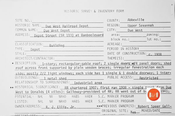
City Directories and History: Due West Railroad Company, under President Robert Speer Galloway, was organized between 1905 and 1907. Local citizens raised funds and the company petitioned the legislature to approve bonds for the railroad. Negotiations began with the Southern Railway that owned the antebellum Columbia to Greenville Railroad that ran through Donalds. The Southern Railway supplied the Due West spur, locally called the “Dinky,” with rails and a contract was let for crossties and lumber for a depot.
-
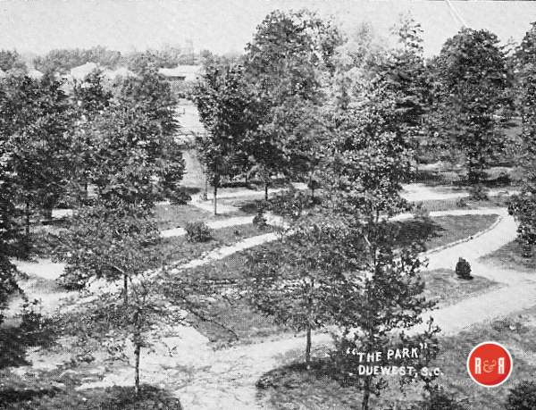
- Images of the Town of Due West, S.C. and the City Park – Images courtesy of James Gettys, 2018
-
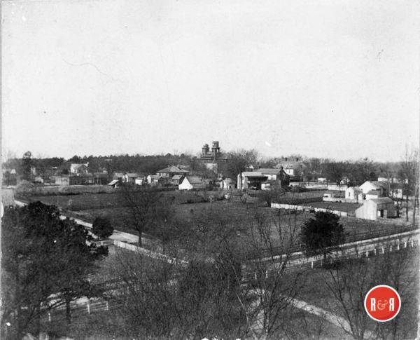
- Early image of Due West, S.C. Courtesy of the James Gettys Collection – 2018
Oscar Sullivan and others began grading the roadbed in the summer of 1907 from Due West to Donalds. An oral tradition is that the surveyor from Greenwood followed elevation contours to avoid excessive excavations resulting in five road crossings along the six-mile route. The roadbed ran parallel to the Due West to Donalds road and crossed Church Street behind the Due West ARP Church cemetery. It then crossed the Donalds highway (Highway 184) just before the town limits, at “Lee’s Crossing” (near the house of Professor Joseph F Lee). The rails ran midway to Donalds on the southeast side of the road before crossing to the northwest side at “Todd’s Crossing” near the J. E. Todd home. It crossed Highway 184 again just inside the Donalds town limits and finally the rails crossed Highway 178 to reach the Donalds station.
The Due West Railroad Company purchased a locomotive, a passenger car and a flatbed car for freight from Bowen Brothers Company of Norfolk, Virginia. The charge of a quarter per ticket was half the cost of a hack. The train ran forward one way and backward on the return trip, and stopped at Lee’s Crossing and Todd’s Crossing. C. W. Bowen, one of the Virginia Bowen Brothers, came to Due West to instruct conductor J. E. McClintock and engineer Jim Rowland. The first engine was small but could carry a few passengers and was replaced within a year. The second engine was dubbed “The Dinky,” a nickname that stuck. Eventually a third engine was secured for passengers leaving the second engine for freight service. In the mid-1920s and passenger service continued until the late 1920s.
The first train from Due West to Donalds ran on January 1, 1908 and Due West citizens went to Donalds or camped along the way. The first accident occurred in 1911 when a cow was hit and killed. President Galloway, possibly fearing legal action that would require compensation for the owner, asked engineer Rowland if he were sure the cow was on the track when it was hit. Rowland presumably replied, “Do you think I was chasing the cow through the woods?” Due West citizens were proud of their new mode of transportation, often spent a quarter just for a ride to Donalds, and when the incredulous asked “you have a railroad only six miles long?” would reply “yes, but it’s as wide as any railroad in the land.”
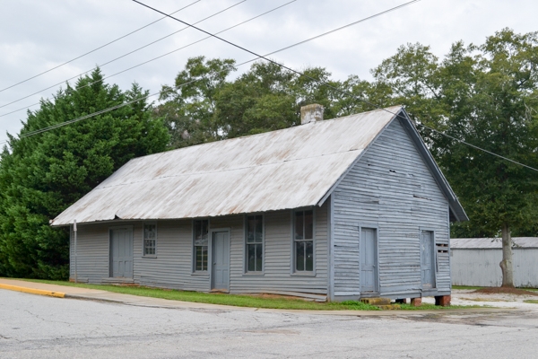
The depot was built in 1907 and as of January 2015 still stands at the corner of Depot and Dode Phillips Streets. The tracks ran parallel to the station on the side away from Dode Phillips Street and continued nearly to Young Street (along what became the front of Erskine College’s Robert Stone Galloway Physical Activities Building). On the west end of the building there was a large coal pile of fuel and beyond that were warehouses, owned by local merchants and cotton brokers.
With the railroad came a real estate boom along what is now Depot Street and investors were not disappointed. Due West soon had a new commercial center along Depot Street, but in 2015 there is virtually no evidence of what was, between 1909 and 1939, a bustling commercial zone. The development of heavyduty highway trucks caused the Due West Railroad to close in 1939.
The Due West Motor Line, a “Participating Carrier” owned by Galloway & Hawthorne, was established in 1939 to carry railroad traffic to a final destination not served by rails. A Participating Carrier received a portion of the railroad freight fees, was regulated and required extensive paper work including posting rates throughout the region.
Sources: Lowry Ware, A Place Called Due West: The Home of Erskine College, 1997, pages 170-174. Interview with Roddey Stephenson Ellis, Jr. on January 2, 2008 (Contributed by James Gettys – 2015)
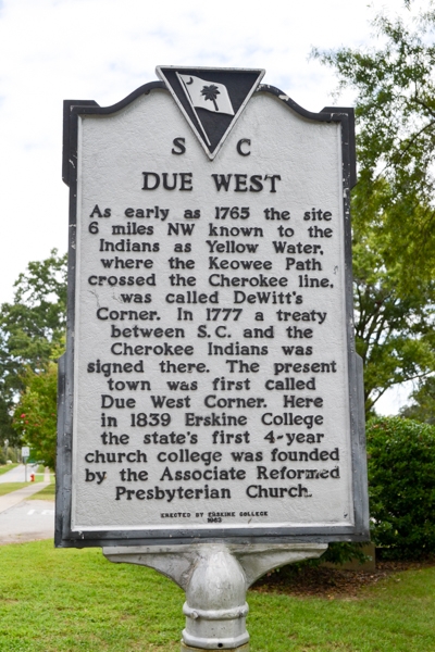
“The Cherokee Indians inhabited the region around the present Due West, but so far as is known there was never an Indian village anywhere near die present town. The white man began to settle on land in this area in the 1750’s. The Cherokees resented this encroachment and a terrible war broke out between the races in 1759. After two years of warfare the whites were able to defeat the Indians with the help of a goodly number of British soldiers.
The treaty of peace marking an end to hostilities established restraining lines above which the white man was forbidden to settle. These lines were surveyed from a point on the Reedy River, north to the North Carolina boundary and west to the Savannah river. They are roughly the present boundaries between Spartanburg and Greenville counties and Anderson and Abbeville counties. This treaty had the effect of reserving for the Cherokees the land now contained in the counties of Anderson, Oconee, Pickens and Greenville. This northwest comer of South Carolina became known as the Indian Land.
Years before these events took place a definite route had been followed by the white traders from Charleston to Keowee, the capital town of the lower Cherokee Indians. This route became known as the Keowee Path, and it was the chief interior trade route of colonial South Carolina. A man by the name of De Witt (pronounced Du ett or Du Wet) settled on this path at the place where the Indian boundary crossed it. This spot became known to the traders as De Witt’s Comer—the comer of the white and Indian land. It evidently became an important landmark and stopping place in the days just prior to the out-break of the Revolutionary war. It was during this war that the whites drove the Cherokees from South Carolina, and at De Witt’s Comer in 1777 a treaty was made in which the Indians agreed to surrender their remaining lands in the state. The exact site of DeWitt’s Comer would be hard to locate today, but it must have been a little south and west of the present Honea Path where there is still a Comer Creek.
During the years following the Revolution the name changed to Due West Comer. The exact reason for such change has never been definitely shown. Some have tried to explain it by saying that the neighborhood expanded due west of the original site, or that the old Keowee Path made a due west turn in the vicinity. The best explanation appears to be that the name is just a corruption of the original name, based on the pronunciation which was Du Wet or Du ett. We know that the places (De Witt and Due West) are the same for records dating from the 1820’s use the names interchangeably.
During the 1830’s the “Comer” was gradually dropped, and, except for an attempt to change the name of the place to Selma, it has remained Due West for over a century. The name has also referred to this particular locality since the 1830’s.”
(This information came from some of the articles of Logan who wrote the History of Upper South Carolina.
Note: Spellings are modem as and was editor of the Abbeville newspaper during part of the 1850’s. It is also based on maps and references from various documents connected with South Carolina History.)
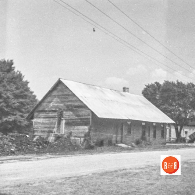
See an early view of the train at the Due West Depot under – More Information beneath the picture column. (Image courtesy of James Gettys – 2015)
Information from: Names in South Carolina by C.H. Neuffer, Published by the S.C. Dept. of English, USC
Stay Connected
Explore history, houses, and stories across S.C. Your membership provides you with updates on regional topics, information on historic research, preservation, and monthly feature articles. But remember R&R wants to hear from you and assist in preserving your own family genealogy and memorabilia.
Visit the Southern Queries – Forum to receive assistance in answering questions, discuss genealogy, and enjoy exploring preservation topics with other members. Also listed are several history and genealogical researchers for hire.
User comments welcome — post at the bottom of this page.
Please enjoy this structure and all those listed in Roots and Recall. But remember each is private property. So view them from a distance or from a public area such as the sidewalk or public road.
Do you have information to share and preserve? Family, school, church, or other older photos and stories are welcome. Send them digitally through the “Share Your Story” link, so they too might be posted on Roots and Recall.
Thanks!

User comments always welcome - please post at the bottom of this page.

